TopoQuest Logo
Do you find TopoQuest useful?
Help keep TopoQuest running and adding new maps/features by donating!
Bitcoin:  19c7KJd3qBynnjoSw5npx9KScwjBe4ifkT
Litecoin:  LXs6TkuXGGXo1vDsWCkWVdjQX94eUKd6ui
Home View Maps Find Maps Find Places Resources & Links


Huttig, Arkansas Topographic Map

USGS Map Title: Huttig, AR
USGS Map MRC: 33092A2
DRG (GeoTIFF) Download: o33092a2.tif


Neighboring USGS Topographic Map Quads:


  New London, AR  
33092B3
 

  New Union, AR  
33092B2
 

  Marais Saline, AR  
33092B1
 

  Strong, AR  
33092A3
 

  Huttig, AR  
33092A2
 

  Felsenthal Dam, AR  
33092A1
 

  Marion West, LA  
32092H3
 

  Marion East, LA  
32092H2
 

  Fish Lake, LA  
32092H1


Map MRC Location:

N34°
W93°
N34°
W92°
H8 H7 H6 H5 H4 H3 H2 H1
G8 G7 G6 G5 G4 G3 G2 G1
F8 F7 F6 F5 F4 F3 F2 F1
E8 E7 E6 E5 E4 E3 E2 E1
D8 D7 D6 D5 D4 D3 D2 D1
C8 C7 C6 C5 C4 C3 C2 C1
B8 B7 B6 B5 B4 B3 B2 B1
A8 A7 A6 A5 A4 A3 A2 A1
N33°
W93°
N33°
W92°

Huttig, AR USGS 1:24K Topographic Map Preview:
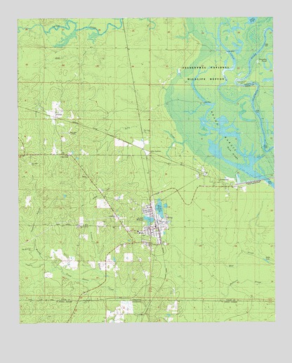
Huttig, AR USGS Topographic Map
Click on map above to begin viewing in our Map Viewer.

This topographic map contains these locations and features:
Feature Name Type Latitude Longitude GNIS ID View Map
Arkansas Noname 55 DamDamN33.0451°W92.1868°80213View Map
Arkansas Noname 55 ReservoirReservoirN33.0451°W92.1868°80214View Map
Arkansas Noname 56 DamDamN33.0418°W92.1885°80215View Map
Arkansas Noname 56 ReservoirReservoirN33.0418°W92.1885°80216View Map
BoldingPopulated PlaceN33.0837°W92.2293°57405View Map
Bolding Methodist ChurchChurchN33.0865°W92.2315°59606View Map
City of HuttigCivilN33.0418°W92.1818°2404751View Map
Culpeper BranchStreamN33.0140°W92.2032°76728View Map
Dollar JunctionPopulated PlaceN33.0701°W92.1879°57670View Map
FelsenthalPopulated PlaceN33.0596°W92.1568°49023View Map
Felsenthal Baptist ChurchChurchN33.0568°W92.1546°59662View Map
First Baptist ChurchChurchN33.0368°W92.1851°59668View Map
Forty Acre MillpondReservoirN33.0468°W92.1812°59681View Map
Grand MaraisLakeN33.0703°W92.1530°77052View Map
Grand Marais Recreation SiteParkN33.0598°W92.1412°75355View Map
Gum RidgeRidgeN33.0707°W92.1451°49722View Map
Harper Springs CemeteryCemeteryN33.0396°W92.2212°59699View Map
Harper Springs ChurchChurchN33.0396°W92.2196°77125View Map
Henderson BendBendN33.0979°W92.1437°50004View Map
Hogg CreekStreamN33.1185°W92.2104°50173View Map
HuttigPopulated PlaceN33.0396°W92.1826°77345View Map
Huttig Ambulance DepartmentBuildingN33.0388°W92.1842°2119025View Map
Huttig CemeteryCemeteryN33.0487°W92.1890°59715View Map
Huttig Elementary SchoolSchoolN33.0368°W92.1905°59708View Map
Huttig High SchoolSchoolN33.0375°W92.1919°59709View Map
Huttig Lookout TowerTowerN33.0687°W92.2254°59710View Map
Huttig Police DepartmentBuildingN33.0390°W92.1832°2118690View Map
Huttig Post OfficePost OfficeN33.0399°W92.1834°84811View Map
Huttig Volunteer Fire DepartmentBuildingN33.0407°W92.1835°2116614View Map
Kelly Spring CreekStreamN33.0757°W92.1610°50799View Map
KTVE-TV (El Dorado)TowerN33.0782°W92.2282°85437View Map
Lawrence BranchStreamN33.0287°W92.2435°51003View Map
Little LakeLakeN33.0255°W92.1287°59735View Map
Mchenry BranchStreamN33.0221°W92.2332°45755View Map
McHenry BranchStreamN33.0249°W92.2376°59742View Map
Old LapilePopulated PlaceN33.0687°W92.2474°57141View Map
Old Lapile CemeteryCemeteryN33.0651°W92.2440°77449View Map
Smith ChapelChurchN33.0401°W92.2121°54942View Map
South Lapile CreekStreamN33.0915°W92.1354°77450View Map
Town of FelsenthalCivilN33.0588°W92.1532°2406496View Map
Twenty Acre MillpondReservoirN33.0425°W92.1864°59873View Map
Wolf SloughGutN33.0223°W92.1440°56501View Map

Note: Coordinates in the location and feature list above are referenced to NAD83 datum.


Copyright (C) 2008-2024 Ryan Niemi / Sunset Dynamics ... All Rights Reserved