TopoQuest Logo
Do you find TopoQuest useful?
Help keep TopoQuest running and adding new maps/features by donating!
Bitcoin:  19c7KJd3qBynnjoSw5npx9KScwjBe4ifkT
Litecoin:  LXs6TkuXGGXo1vDsWCkWVdjQX94eUKd6ui
Home View Maps Find Maps Find Places Resources & Links


Felsenthal Dam, Arkansas Topographic Map

USGS Map Title: Felsenthal Dam, AR
USGS Map MRC: 33092A1
DRG (GeoTIFF) Download: o33092a1.tif


Neighboring USGS Topographic Map Quads:


  New Union, AR  
33092B2
 

  Marais Saline, AR  
33092B1
 

  Crossett North, AR  
33091B8
 

  Huttig, AR  
33092A2
 

  Felsenthal Dam, AR  
33092A1
 

  Crossett South, AR  
33091A8
 

  Marion East, LA  
32092H2
 

  Fish Lake, LA  
32092H1
 

  Beekman, LA  
32091H8


Map MRC Location:

N34°
W93°
N34°
W92°
H8 H7 H6 H5 H4 H3 H2 H1
G8 G7 G6 G5 G4 G3 G2 G1
F8 F7 F6 F5 F4 F3 F2 F1
E8 E7 E6 E5 E4 E3 E2 E1
D8 D7 D6 D5 D4 D3 D2 D1
C8 C7 C6 C5 C4 C3 C2 C1
B8 B7 B6 B5 B4 B3 B2 B1
A8 A7 A6 A5 A4 A3 A2 A1
N33°
W93°
N33°
W92°

Felsenthal Dam, AR USGS 1:24K Topographic Map Preview:
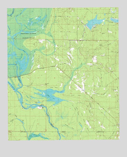
Felsenthal Dam, AR USGS Topographic Map
Click on map above to begin viewing in our Map Viewer.

This topographic map contains these locations and features:
Feature Name Type Latitude Longitude GNIS ID View Map
Big Mound RidgeRidgeN33.0526°W92.0876°46585View Map
Black SloughGutN33.0951°W92.0740°46678View Map
Black Spring SloughGutN33.0215°W92.0462°46680View Map
Boyd - Hedge CemeteryCemeteryN33.0471°W92.0068°62421View Map
Buckhorn SloughStreamN33.0237°W92.1146°533505View Map
Buckhorn SloughStreamN33.0515°W92.1229°47143View Map
Bull BrakeSwampN33.0854°W92.1090°62419View Map
C D SidingLocaleN33.0665°W92.0660°47258View Map
Clear LakeLakeN33.0185°W92.1109°74747View Map
Coffee CreekStreamN33.0288°W92.0809°47886View Map
Coffee Creek ReliefCanalN33.1015°W92.0390°62423View Map
Coffee PrairieFlatN33.0504°W92.0729°47888View Map
Cooley LakeLakeN33.0358°W92.0903°74755View Map
Deadpecker SloughGutN33.0185°W92.0254°48427View Map
Deadpecker SloughGutN33.0037°W92.0187°534436View Map
Felsenthal Lock and DamDamN33.0608°W92.1137°59663View Map
Fish SloughGutN33.0535°W92.0979°49066View Map
Gar SloughGutN33.0307°W92.0510°62420View Map
Gilliam SloughGutN33.0196°W92.0110°49417View Map
Halfway BayouSwampN33.0110°W92.0538°49774View Map
Horseshoe SloughGutN33.1065°W92.1249°50345View Map
Humphrey SloughGutN33.0421°W92.0171°50409View Map
Indian CreekStreamN33.0710°W92.0415°50502View Map
Lock and Dam Number 6DamN33.0327°W92.0886°59736View Map
Macedonian CemeteryCemeteryN33.1003°W92.0197°77573View Map
Macedonian Church (historical)ChurchN33.1015°W92.0196°62424View Map
Mill PondReservoirN33.1103°W92.0284°80318View Map
Mill Pond DamDamN33.1068°W92.0351°80317View Map
Mossy LakeLakeN33.0421°W92.0771°74752View Map
Mossy LakeLakeN33.0421°W92.0771°77698View Map
Ouachita River ReservoirReservoirN33.0318°W92.0885°79574View Map
Pine IslandIslandN33.0907°W92.0932°53451View Map
Redeye LakeLakeN33.1022°W92.1009°75100View Map
Rolands RaftBarN33.0373°W92.1093°75300View Map
Russell IslandFlatN33.0435°W92.0482°54287View Map
Sulphur SpringSpringN33.0696°W92.0331°62422View Map
Sulphur SpringsPopulated PlaceN33.0718°W92.0312°78493View Map
Three Beech PrairieFlatN33.0054°W92.0282°539907View Map
Three Beech PrairieFlatN33.0196°W92.0390°55556View Map
Township of Marais SalineCivilN33.0551°W92.0450°63679View Map
VenicePopulated PlaceN33.0371°W92.0279°58800View Map
Wildcat LakeLakeN33.0803°W92.1212°74623View Map

Note: Coordinates in the location and feature list above are referenced to NAD83 datum.


Copyright (C) 2008-2025 Ryan Niemi / Sunset Dynamics ... All Rights Reserved