TopoQuest Logo
Do you find TopoQuest useful?
Help keep TopoQuest running and adding new maps/features by donating!
Bitcoin:  19c7KJd3qBynnjoSw5npx9KScwjBe4ifkT
Litecoin:  LXs6TkuXGGXo1vDsWCkWVdjQX94eUKd6ui
Home View Maps Find Maps Find Places Resources & Links


Marble Mountain, California Topographic Map

USGS Map Title: Marble Mountain, CA
USGS Map MRC: 41123E2
DRG (GeoTIFF) Download: o41123e2.tif


Neighboring USGS Topographic Map Quads:


  Huckleberry Mountain, CA  
41123F3
 

  Grider Valley, CA  
41123F2
 

  Scott Bar, CA  
41123F1
 

  Ukonom Lake, CA  
41123E3
 

  Marble Mountain, CA  
41123E2
 

  Boulder Peak, CA  
41123E1
 

  Medicine Mountain, CA  
41123D3
 

  English Peak, CA  
41123D2
 

  Yellow Dog Peak, CA  
41123D1


Map MRC Location:

N42°
W124°
N42°
W123°
H8 H7 H6 H5 H4 H3 H2 H1
G8 G7 G6 G5 G4 G3 G2 G1
F8 F7 F6 F5 F4 F3 F2 F1
E8 E7 E6 E5 E4 E3 E2 E1
D8 D7 D6 D5 D4 D3 D2 D1
C8 C7 C6 C5 C4 C3 C2 C1
B8 B7 B6 B5 B4 B3 B2 B1
A8 A7 A6 A5 A4 A3 A2 A1
N41°
W124°
N41°
W123°

Marble Mountain, CA USGS 1:24K Topographic Map Preview:
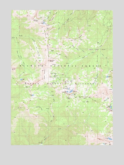
Marble Mountain, CA USGS Topographic Map
Click on map above to begin viewing in our Map Viewer.

This topographic map contains these locations and features:
Feature Name Type Latitude Longitude GNIS ID View Map
Ananias CampLocaleN41.5449°W123.2003°256233View Map
Anthony Milne CampLocaleN41.5012°W123.2117°256290View Map
Big Elk ForkStreamN41.5068°W123.2075°256922View Map
Big Elk LakeLakeN41.5461°W123.2242°256923View Map
Big Rock CampLocaleN41.5871°W123.2045°256997View Map
Big Rock ForkStreamN41.5762°W123.1759°256998View Map
Black Marble MountainSummitN41.5776°W123.2039°257139View Map
Box CampLocaleN41.6046°W123.1578°257406View Map
Box Camp MountainSummitN41.5985°W123.1803°1658120View Map
Cold SpringSpringN41.5400°W123.1597°258552View Map
Dads PocketBasinN41.5340°W123.2367°259010View Map
Death ValleyBasinN41.5935°W123.1837°259169View Map
Death Valley CreekStreamN41.5796°W123.1653°259170View Map
Deep Lake CreekStreamN41.6076°W123.1270°259196View Map
Elk ValleyValleyN41.6010°W123.2423°259862View Map
Frying Pan LakeLakeN41.5521°W123.1804°260437View Map
Gate LakeLakeN41.5584°W123.1832°260506View Map
Gem LakeLakeN41.5454°W123.1334°260512View Map
Grindstone CampLocaleN41.5854°W123.1603°260898View Map
Jewel LakeLakeN41.5425°W123.1344°261940View Map
JumpoffRidgeN41.5885°W123.1950°262040View Map
Kings CastleSummitN41.6157°W123.2225°262183View Map
Kleaver LakeLakeN41.5011°W123.1372°262210View Map
Little Elk LakeLakeN41.5632°W123.1329°262597View Map
Little Elk Lake CreekStreamN41.5871°W123.1417°262598View Map
Little Marble ValleyBasinN41.5562°W123.1970°262662View Map
Lovers CampLocaleN41.5887°W123.1470°262983View Map
Lower Sky High LakeLakeN41.5498°W123.1774°263046View Map
Man Eaten LakeLakeN41.5058°W123.1295°263152View Map
Marble MountainSummitN41.5610°W123.2114°263196View Map
Marble ValleyBasinN41.5668°W123.1967°228074View Map
Marble Valley Guard StationLocaleN41.5654°W123.2000°263202View Map
Millers Cabin (historical)BuildingN41.5360°W123.1687°1682354View Map
Paradise LakeLakeN41.6127°W123.2109°264511View Map
Rainy LakeLakeN41.5605°W123.2386°265152View Map
Rainy ValleyValleyN41.5974°W123.2464°265153View Map
Rainy Valley CreekStreamN41.5982°W123.2498°265154View Map
Red Rock CreekStreamN41.5901°W123.1423°265322View Map
Red Rock ValleyValleyN41.5879°W123.1417°265330View Map
Shadow LakeLakeN41.5470°W123.1751°266023View Map
Sky High ValleyValleyN41.5624°W123.1823°1657424View Map
Soft Water SpringSpringN41.5436°W123.1781°267376View Map
South Fork Wooley CreekStreamN41.5001°W123.2148°267522View Map
Summit LakeLakeN41.5353°W123.1284°267934View Map
Summit Meadow LakeLakeN41.5330°W123.1264°267943View Map
Upper Sky High LakeLakeN41.5493°W123.1818°268639View Map
Whisky CampLocaleN41.5537°W123.2320°268969View Map
Wooley Creek PocketBasinN41.5351°W123.2156°269313View Map

Note: Coordinates in the location and feature list above are referenced to NAD83 datum.


Copyright (C) 2008-2024 Ryan Niemi / Sunset Dynamics ... All Rights Reserved