TopoQuest Logo
Do you find TopoQuest useful?
Help keep TopoQuest running and adding new maps/features by donating!
Bitcoin:  19c7KJd3qBynnjoSw5npx9KScwjBe4ifkT
Litecoin:  LXs6TkuXGGXo1vDsWCkWVdjQX94eUKd6ui
Home View Maps Find Maps Find Places Resources & Links


Martindale, Texas Topographic Map

USGS Map Title: Martindale, TX
USGS Map MRC: 29097G7
DRG (GeoTIFF) Download: o29097g7.tif


Neighboring USGS Topographic Map Quads:


  San Marcos North, TX  
29097H8
 

  Uhland, TX  
29097H7
 

  Lockhart North, TX  
29097H6
 

  San Marcos South, TX  
29097G8
 

  Martindale, TX  
29097G7
 

  Lockhart South, TX  
29097G6
 

  Geronimo, TX  
29097F8
 

  Kingsbury, TX  
29097F7
 

  Luling, TX  
29097F6


Map MRC Location:

N30°
W98°
N30°
W97°
H8 H7 H6 H5 H4 H3 H2 H1
G8 G7 G6 G5 G4 G3 G2 G1
F8 F7 F6 F5 F4 F3 F2 F1
E8 E7 E6 E5 E4 E3 E2 E1
D8 D7 D6 D5 D4 D3 D2 D1
C8 C7 C6 C5 C4 C3 C2 C1
B8 B7 B6 B5 B4 B3 B2 B1
A8 A7 A6 A5 A4 A3 A2 A1
N29°
W98°
N29°
W97°

Martindale, TX USGS 1:24K Topographic Map Preview:
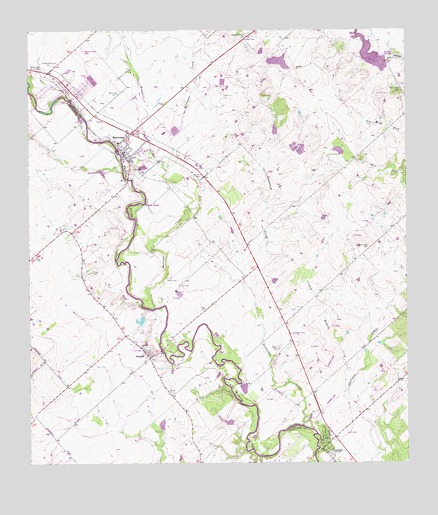
Martindale, TX USGS Topographic Map
Click on map above to begin viewing in our Map Viewer.

This topographic map contains these locations and features:
Feature Name Type Latitude Longitude GNIS ID View Map
Barber SpringsSpringN29.8683°W97.7539°1998652View Map
City of MartindaleCivilN29.8448°W97.8397°2411044View Map
City of StaplesCivilN29.7663°W97.8279°2633299View Map
Cliett CemeteryCemeteryN29.8035°W97.8292°1354661View Map
Cooper LakeReservoirN29.8661°W97.7924°1860993View Map
Cooper Lake DamDamN29.8669°W97.7969°1860992View Map
Crooked BranchStreamN29.7724°W97.7694°1355378View Map
Dickerson CreekStreamN29.7597°W97.7817°1356013View Map
FentressPopulated PlaceN29.7561°W97.7764°1357289View Map
Fentress AirparkAirportN29.7701°W97.7729°1386631View Map
Fentress Post OfficePost OfficeN29.7579°W97.7766°2731743View Map
Garden of the Cross CemeteryCemeteryN29.8652°W97.8669°1357865View Map
Grouskay-Fisher LakeReservoirN29.8463°W97.7938°1865299View Map
Grouskay-Fisher Lake DamDamN29.8452°W97.7936°1865298View Map
Hemphill CreekStreamN29.8363°W97.8300°1374036View Map
Humphrey CemeteryCemeteryN29.8330°W97.8197°1359825View Map
Isidora CemeteryCemeteryN29.7833°W97.7928°1360045View Map
Kennedy CemeteryCemeteryN29.8374°W97.8328°1360577View Map
Langford LakeReservoirN29.7719°W97.8069°1865303View Map
Langford Lake DamDamN29.7719°W97.8069°1865302View Map
MartindalePopulated PlaceN29.8455°W97.8408°1362235View Map
Martindale CemeteryCemeteryN29.8569°W97.8450°1362236View Map
Martindale City HallBuildingN29.8397°W97.8437°2753837View Map
Martindale DivisionCivilN29.8284°W97.7866°1938969View Map
Martindale Police DepartmentBuildingN29.8397°W97.8437°2739270View Map
Martindale Post OfficePost OfficeN29.8446°W97.8428°2731304View Map
Martindale Volunteer Fire DepartmentBuildingN29.8428°W97.8452°2552422View Map
Memory Lawn Memorial ParkCemeteryN29.8638°W97.8700°1362608View Map
Morrison CreekStreamN29.7952°W97.8333°1375009View Map
Santa Maria Aida CemeteryCemeteryN29.8744°W97.8017°1367750View Map
Soil Conservation Service Site 34 DamDamN29.8652°W97.7553°1860994View Map
Soil Conservation Service Site 34 ReservoirReservoirN29.8680°W97.7616°1860995View Map
StaplesPopulated PlaceN29.7813°W97.8361°1369103View Map
Staples CemeteryCemeteryN29.7705°W97.8278°1369104View Map
Staples Post OfficePost OfficeN29.7793°W97.8369°2732352View Map
Tuttle CemeteryCemeteryN29.8052°W97.8544°1370314View Map

Note: Coordinates in the location and feature list above are referenced to NAD83 datum.


Copyright (C) 2008-2025 Ryan Niemi / Sunset Dynamics ... All Rights Reserved