TopoQuest Logo
Do you find TopoQuest useful?
Help keep TopoQuest running and adding new maps/features by donating!
Bitcoin:  19c7KJd3qBynnjoSw5npx9KScwjBe4ifkT
Litecoin:  LXs6TkuXGGXo1vDsWCkWVdjQX94eUKd6ui
Home View Maps Find Maps Find Places Resources & Links


Uhland, Texas Topographic Map

USGS Map Title: Uhland, TX
USGS Map MRC: 29097H7
DRG (GeoTIFF) Download: o29097h7.tif


Neighboring USGS Topographic Map Quads:


  Mountain City, TX  
30097A8
 

  Buda, TX  
30097A7
 

  Creedmoor, TX  
30097A6
 

  San Marcos North, TX  
29097H8
 

  Uhland, TX  
29097H7
 

  Lockhart North, TX  
29097H6
 

  San Marcos South, TX  
29097G8
 

  Martindale, TX  
29097G7
 

  Lockhart South, TX  
29097G6


Map MRC Location:

N30°
W98°
N30°
W97°
H8 H7 H6 H5 H4 H3 H2 H1
G8 G7 G6 G5 G4 G3 G2 G1
F8 F7 F6 F5 F4 F3 F2 F1
E8 E7 E6 E5 E4 E3 E2 E1
D8 D7 D6 D5 D4 D3 D2 D1
C8 C7 C6 C5 C4 C3 C2 C1
B8 B7 B6 B5 B4 B3 B2 B1
A8 A7 A6 A5 A4 A3 A2 A1
N29°
W98°
N29°
W97°

Uhland, TX USGS 1:24K Topographic Map Preview:
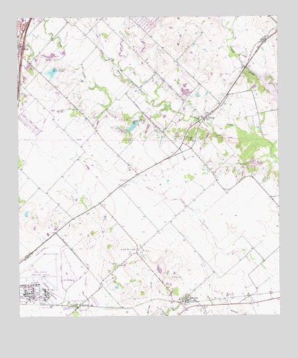
Uhland, TX USGS Topographic Map
Click on map above to begin viewing in our Map Viewer.

This topographic map contains these locations and features:
Feature Name Type Latitude Longitude GNIS ID View Map
Alexander LakeReservoirN29.9747°W97.8721°1865204View Map
Alexander Lake DamDamN29.9752°W97.8736°1865203View Map
Bunton BranchStreamN29.9630°W97.8019°1331658View Map
Caldwell County Constable's Office Precinct 3BuildingN29.8765°W97.7966°2739503View Map
Chisholm Trail Fire and Rescue Station 4BuildingN29.9573°W97.7852°2552615View Map
City of NiederwaldCivilN29.9996°W97.7637°2411256View Map
City of UhlandCivilN29.9615°W97.7811°2412124View Map
Doyle CemeteryCemeteryN29.9297°W97.8242°1334590View Map
Koeglar HillSummitN29.9022°W97.8172°1339208View Map
Koeglar Hill CemeteryCemeteryN29.8970°W97.8268°1339209View Map
Kyle Volunteer Fire Department Station 3BuildingN29.9986°W97.8199°2552495View Map
Live Oak CemeteryCemeteryN29.9497°W97.7903°1340239View Map
M D Heatly DamDamN29.9536°W97.8236°1857381View Map
M D Heatly ReservoirReservoirN29.9526°W97.8245°1857382View Map
MaxwellPopulated PlaceN29.8811°W97.7933°1341098View Map
Maxwell CemeteryCemeteryN29.8788°W97.7875°1341100View Map
Maxwell Post OfficePost OfficeN29.8786°W97.7955°2731332View Map
Maxwell Volunteer Fire DepartmentBuildingN29.8771°W97.7959°2552372View Map
Porter CreekStreamN29.9649°W97.8097°1344374View Map
ReedvillePopulated PlaceN29.8797°W97.8464°1345006View Map
San Juan CemeteryCemeteryN29.8819°W97.8431°1346399View Map
San Marcos Army Air Field (historical)MilitaryN29.8900°W97.8656°2096203View Map
San Marcos Municipal AirportAirportN29.8879°W97.8630°1387500View Map
San Miguel ChurchChurchN29.9483°W97.7906°1346432View Map
Schawe CemeteryCemeteryN29.8783°W97.8025°1346760View Map
Soil Conservation Service Site 2 DamDamN29.9852°W97.8569°1857375View Map
Soil Conservation Service Site 2 ReservoirReservoirN29.9838°W97.8606°1857376View Map
Soil Conservation Service Site 3 DamDamN29.9786°W97.8569°1857377View Map
Soil Conservation Service Site 3 ReservoirReservoirN29.9775°W97.8582°1857378View Map
Soil Conservation Service Site 4 DamDamN29.9569°W97.8203°1857379View Map
Soil Conservation Service Site 4 ReservoirReservoirN29.9550°W97.8198°1857380View Map
Soil Conservation Service Site 7 DamDamN29.9686°W97.7953°1863477View Map
Soil Conservation Service Site 7 ReservoirReservoirN29.9687°W97.7954°1863478View Map
Soil Conservation Service Site 8 DamDamN29.9386°W97.7619°1860996View Map
Soil Conservation Service Site 8 ReservoirReservoirN29.9385°W97.7622°1860997View Map
Texas Department of Criminal Justice Kyle Correctional CenterBuildingN29.9784°W97.8718°2767818View Map
UhlandPopulated PlaceN29.9577°W97.7861°1349016View Map
Uhland City HallBuildingN29.9583°W97.7836°2753224View Map
Uhland Volunteer Fire DepartmentBuildingN29.9593°W97.7841°2552489View Map

Note: Coordinates in the location and feature list above are referenced to NAD83 datum.


Copyright (C) 2008-2025 Ryan Niemi / Sunset Dynamics ... All Rights Reserved