TopoQuest Logo
Do you find TopoQuest useful?
Help keep TopoQuest running and adding new maps/features by donating!
Bitcoin:  19c7KJd3qBynnjoSw5npx9KScwjBe4ifkT
Litecoin:  LXs6TkuXGGXo1vDsWCkWVdjQX94eUKd6ui
Home View Maps Find Maps Find Places Resources & Links


San Marcos South, Texas Topographic Map

USGS Map Title: San Marcos South, TX
USGS Map MRC: 29097G8
DRG (GeoTIFF) Download: o29097g8.tif


Neighboring USGS Topographic Map Quads:


  Wimberley, TX  
29098H1
 

  San Marcos North, TX  
29097H8
 

  Uhland, TX  
29097H7
 

  Hunter, TX  
29098G1
 

  San Marcos South, TX  
29097G8
 

  Martindale, TX  
29097G7
 

  New Braunfels East, TX  
29098F1
 

  Geronimo, TX  
29097F8
 

  Kingsbury, TX  
29097F7


Map MRC Location:

N30°
W98°
N30°
W97°
H8 H7 H6 H5 H4 H3 H2 H1
G8 G7 G6 G5 G4 G3 G2 G1
F8 F7 F6 F5 F4 F3 F2 F1
E8 E7 E6 E5 E4 E3 E2 E1
D8 D7 D6 D5 D4 D3 D2 D1
C8 C7 C6 C5 C4 C3 C2 C1
B8 B7 B6 B5 B4 B3 B2 B1
A8 A7 A6 A5 A4 A3 A2 A1
N29°
W98°
N29°
W97°

San Marcos South, TX USGS 1:24K Topographic Map Preview:
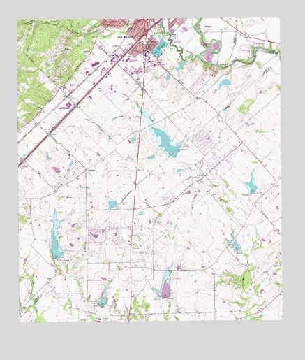
San Marcos South, TX USGS Topographic Map
Click on map above to begin viewing in our Map Viewer.

This topographic map contains these locations and features:
Feature Name Type Latitude Longitude GNIS ID View Map
Air - Evac Lifeteam San MarcosBuildingN29.8535°W97.9470°2656006View Map
Alison Air ParkAirportN29.8303°W97.8892°1387501View Map
Aquarena Springs MuseumBuildingN29.8552°W97.9592°2014594View Map
Bading CemeteryCemeteryN29.7680°W97.9850°1351396View Map
Blanco RiverStreamN29.8599°W97.9133°1372625View Map
Bonham Early Childhood CenterSchoolN29.8747°W97.9389°2006613View Map
Bowie Elementary SchoolSchoolN29.8208°W97.9415°2006615View Map
Bowie SchoolSchoolN29.8616°W97.9369°1352744View Map
CenterpointLocaleN29.8130°W97.9672°1354214View Map
Central Texas Medical CenterHospitalN29.8527°W97.9458°2015776View Map
City of San MarcosCivilN29.8734°W97.9380°2411798View Map
Crayton CemeteryCemeteryN29.7724°W97.8797°1355334View Map
Dam Number 10DamN29.7597°W97.9306°1355565View Map
Dam Number 13DamN29.8205°W97.9239°1355569View Map
Dam Number 14DamN29.8036°W97.8881°1355572View Map
Dam Number 15DamN29.7794°W97.8958°1355574View Map
Dam Number 5DamN29.7769°W97.9819°1355599View Map
Dam Number 7DamN29.7569°W97.9622°1355603View Map
Dunbar ParkParkN29.8749°W97.9472°2028451View Map
First Baptist ChurchChurchN29.8738°W97.9478°2020060View Map
General Edward Burleson HouseBuildingN29.8552°W97.9592°2014598View Map
Goodnight Junior High SchoolSchoolN29.8605°W97.9469°2006625View Map
Hays County Constable's Office Precinct 1BuildingN29.8651°W97.9539°2739375View Map
Hernandez Intermediate SchoolSchoolN29.8680°W97.9692°2006628View Map
John F Baugh DamDamN29.8486°W97.9003°1857367View Map
John F Baugh ReservoirReservoirN29.8484°W97.9018°1857368View Map
John Stokes ParkParkN29.8669°W97.9292°2029077View Map
McKie-Bass BuildingBuildingN29.8736°W97.9417°2030736View Map
Pitts CemeteryCemeteryN29.8372°W97.9889°1365361View Map
Prime Outlets at San MarcosLocaleN29.8277°W97.9858°2030348View Map
RedwoodPopulated PlaceN29.8102°W97.9114°1366288View Map
Redwood ArenaParkN29.8149°W97.9033°2027684View Map
Redwood CemeteryCemeteryN29.8058°W97.9078°1366289View Map
Redwood Census Designated PlaceCensusN29.8100°W97.9103°2409156View Map
Saint Johns Catholic ChurchChurchN29.8730°W97.9411°2020067View Map
San Marcos - Hays County Emergency Medical ServiceBuildingN29.8658°W97.9408°2656182View Map
San Marcos High SchoolSchoolN29.8232°W97.9495°2006635View Map
San Marcos Police DepartmentBuildingN29.8547°W97.9573°2739266View Map
San Marcos Post OfficePost OfficeN29.8621°W97.9639°2731276View Map
San Marcos Telephone CompanyBuildingN29.8733°W97.9422°2032676View Map
San Pedro CemeteryCemeteryN29.8055°W97.9820°1367535View Map
Scrutchin LakeReservoirN29.8554°W97.9227°1857370View Map
Scrutchin Lake DamDamN29.8569°W97.9236°1857369View Map
Second Baptist ChurchChurchN29.8744°W97.9550°2020065View Map
Soil Conservation Service Site 10 DamDamN29.7599°W97.9300°1857411View Map
Soil Conservation Service Site 10 ReservoirReservoirN29.7627°W97.9309°1857412View Map
Soil Conservation Service Site 13 DamDamN29.8205°W97.9242°1857413View Map
Soil Conservation Service Site 13 ReservoirReservoirN29.8237°W97.9295°1857414View Map
Soil Conservation Service Site 14 DamDamN29.8032°W97.8884°1857415View Map
Soil Conservation Service Site 14 ReservoirReservoirN29.8054°W97.8892°1857416View Map
Soil Conservation Service Site 15 DamDamN29.7802°W97.8969°1857417View Map
Soil Conservation Service Site 15 ReservoirReservoirN29.7807°W97.8971°1857418View Map
Soil Conservation Service Site 5 DamDamN29.7764°W97.9815°1857365View Map
Soil Conservation Service Site 5 ReservoirReservoirN29.7806°W97.9828°1857366View Map
Soil Conservation Service Site 7 DamDamN29.7568°W97.9616°1857409View Map
Soil Conservation Service Site 7 ReservoirReservoirN29.7584°W97.9606°1857410View Map
South Hays Fire Department Company 1BuildingN29.8721°W97.9548°2031199View Map
South Ridge Estates LakeReservoirN29.8129°W97.9818°1863388View Map
South Ridge Estates Lake DamDamN29.8119°W97.9803°1863387View Map
Water Hole CreekStreamN29.7555°W97.9928°1370908View Map
Webster LakeReservoirN29.7987°W97.9557°1857372View Map
Webster Lake DamDamN29.7986°W97.9536°1857371View Map
Willow Springs CreekStreamN29.8699°W97.9306°1371675View Map
Wood State Fish HatcheryLocaleN29.8627°W97.9311°1384711View Map
ZornPopulated PlaceN29.7530°W97.9481°1372107View Map

Note: Coordinates in the location and feature list above are referenced to NAD83 datum.


Copyright (C) 2008-2025 Ryan Niemi / Sunset Dynamics ... All Rights Reserved