TopoQuest Logo
Do you find TopoQuest useful?
Help keep TopoQuest running and adding new maps/features by donating!
Bitcoin:  19c7KJd3qBynnjoSw5npx9KScwjBe4ifkT
Litecoin:  LXs6TkuXGGXo1vDsWCkWVdjQX94eUKd6ui
Home View Maps Find Maps Find Places Resources & Links


Martinsville, Indiana Topographic Map

USGS Map Title: Martinsville, IN
USGS Map MRC: 39086D4
DRG (GeoTIFF) Download: o39086d4.tif


Neighboring USGS Topographic Map Quads:


  Hall, IN  
39086E5
 

  Mooresville West, IN  
39086E4
 

  Mooresville East, IN  
39086E3
 

  Paragon, IN  
39086D5
 

  Martinsville, IN  
39086D4
 

  Cope, IN  
39086D3
 

  Modesto, IN  
39086C5
 

  Hindustan, IN  
39086C4
 

  Morgantown, IN  
39086C3


Map MRC Location:

N40°
W87°
N40°
W86°
H8 H7 H6 H5 H4 H3 H2 H1
G8 G7 G6 G5 G4 G3 G2 G1
F8 F7 F6 F5 F4 F3 F2 F1
E8 E7 E6 E5 E4 E3 E2 E1
D8 D7 D6 D5 D4 D3 D2 D1
C8 C7 C6 C5 C4 C3 C2 C1
B8 B7 B6 B5 B4 B3 B2 B1
A8 A7 A6 A5 A4 A3 A2 A1
N39°
W87°
N39°
W86°

Martinsville, IN USGS 1:24K Topographic Map Preview:
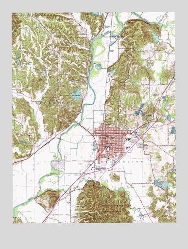
Martinsville, IN USGS Topographic Map
Click on map above to begin viewing in our Map Viewer.

This topographic map contains these locations and features:
Feature Name Type Latitude Longitude GNIS ID View Map
Bald Hill RidgeRidgeN39.3803°W86.4433°430446View Map
Barnard HillSummitN39.4945°W86.4075°430496View Map
Blue BluffCliffN39.4937°W86.3967°431216View Map
Bradford Wood Lake DamDamN39.4987°W86.4333°447254View Map
Buckner BranchStreamN39.3817°W86.4953°431753View Map
Burton HollowValleyN39.3979°W86.4321°431883View Map
Buzzard PointRidgeN39.3762°W86.4381°431919View Map
Campbell SidingLocaleN39.4773°W86.4253°452272View Map
Canada HollowValleyN39.3817°W86.4528°432098View Map
Central Elementary SchoolSchoolN39.4256°W86.4239°432364View Map
Champlin MeadowsPopulated PlaceN39.4075°W86.4367°432392View Map
City of MartinsvilleCivilN39.4227°W86.4209°2395032View Map
Clark HillSummitN39.4798°W86.4086°432561View Map
Clear CreekStreamN39.4931°W86.3875°432610View Map
Clear Creek FisheriesLocaleN39.4294°W86.3767°2650293View Map
Cross Union ChurchChurchN39.3909°W86.3808°433189View Map
Dalton LakeReservoirN39.4649°W86.4232°447900View Map
Dalton Lake DamDamN39.4634°W86.4250°447899View Map
Durham Drive LakeReservoirN39.4823°W86.3970°448789View Map
Durham Drive Lake DamDamN39.4817°W86.3967°448790View Map
East SchoolSchoolN39.4242°W86.4125°433927View Map
ElkPopulated PlaceN39.4459°W86.4292°446720View Map
Fewell RhoadesPopulated PlaceN39.4214°W86.3994°434468View Map
Fish Hatchery LakeReservoirN39.4845°W86.3867°447874View Map
Fish Hatchery Lake DamDamN39.4845°W86.3867°447875View Map
Foster CemeteryCemeteryN39.4670°W86.4746°434699View Map
Fox CliffCliffN39.4912°W86.3892°434737View Map
Foxcliff LakeReservoirN39.4803°W86.3850°447606View Map
Foxcliff Lake DamDamN39.4817°W86.3833°447607View Map
Frakers Mobile Home CourtPopulated PlaceN39.4078°W86.4203°2515660View Map
Goose CreekStreamN39.4381°W86.4819°435181View Map
Grassy ForkStreamN39.4770°W86.3753°435350View Map
Greasy HollowValleyN39.3939°W86.4209°435379View Map
Gregg Township Volunteer Fire Department Station 2BuildingN39.4527°W86.4543°2626492View Map
Hick's Mobile Home ParkPopulated PlaceN39.4292°W86.4367°2515665View Map
Highland CreekStreamN39.4839°W86.4381°436165View Map
Hilldale CemeteryCemeteryN39.4263°W86.4103°436190View Map
HyndsdalePopulated PlaceN39.4159°W86.4847°436675View Map
Indian CreekStreamN39.3987°W86.4492°436743View Map
IU Health MorganHospitalN39.4259°W86.4049°2660445View Map
Jakes ButteSummitN39.4603°W86.4806°436913View Map
Jordan CreekStreamN39.3803°W86.4744°437114View Map
Lahr Lake DamDamN39.4684°W86.4950°447877View Map
Lake EdgewoodReservoirN39.4518°W86.4495°448612View Map
Lake Edgewood DamDamN39.4484°W86.4483°448611View Map
Lambs CreekStreamN39.4128°W86.4658°437585View Map
Laveianan CourtPopulated PlaceN39.4075°W86.4192°2515659View Map
Lincoln HillSummitN39.4456°W86.4169°437912View Map
Little Indian CreekStreamN39.3792°W86.4983°438078View Map
MartinsvillePopulated PlaceN39.4278°W86.4283°438684View Map
Martinsville Country ClubLocaleN39.4509°W86.3875°452357View Map
Martinsville Fire DepartmentBuildingN39.4262°W86.4270°2625875View Map
Martinsville Fire DepartmentBuildingN39.4282°W86.4306°2701415View Map
Martinsville Fire Station 14BuildingN39.4262°W86.4270°2701414View Map
Martinsville High SchoolSchoolN39.4203°W86.4278°447325View Map
Martinsville Police DepartmentBuildingN39.4262°W86.4270°2758101View Map
MaxwellPopulated PlaceN39.3873°W86.4556°438752View Map
Maxwell CemeteryCemeteryN39.3828°W86.4691°438755View Map
Maxwell HillSummitN39.3898°W86.4678°438757View Map
Mc Daniel's FieldAirportN39.4094°W86.4427°449260View Map
McDanielPopulated PlaceN39.4120°W86.4408°438849View Map
Morgan CountyCivilN39.4815°W86.4462°450375View Map
Morgan County Emergency ManagementBuildingN39.4416°W86.4189°2719392View Map
Morgan Monroe State ForestForestN39.3792°W86.4250°447657View Map
Mount Olive ChapelChurchN39.4878°W86.4700°439615View Map
Mount Olive ChurchChurchN39.4781°W86.4689°439627View Map
North Elementary SchoolSchoolN39.4320°W86.4278°440293View Map
Nutter CemeteryCemeteryN39.4637°W86.4231°440374View Map
Nutter DitchCanalN39.4120°W86.4489°440377View Map
Pear RidgeRidgeN39.3848°W86.4436°440959View Map
Pollard HillSummitN39.4023°W86.4200°441413View Map
Poston Road Elementary SchoolSchoolN39.4131°W86.4256°441489View Map
PratherPopulated PlaceN39.3781°W86.4553°441567View Map
Pumpkinvine HillSummitN39.4453°W86.4622°441644View Map
Rural / Metro Ambulance - MartinsvilleBuildingN39.4314°W86.3954°2719410View Map
Saint Martins ChurchChurchN39.4303°W86.4083°442684View Map
Sally Bradley BranchStreamN39.4512°W86.4931°442936View Map
Sand CreekStreamN39.3950°W86.4147°442966View Map
Sartor DitchCanalN39.4137°W86.4181°443035View Map
ShelburnePopulated PlaceN39.4353°W86.3928°443343View Map
Shultz CemeteryCemeteryN39.4275°W86.4911°443119View Map
Slaughterhouse HillSummitN39.4587°W86.4467°443598View Map
Smith LakeReservoirN39.4712°W86.4953°448791View Map
Smith Lake DamDamN39.4734°W86.4950°448792View Map
South SchoolSchoolN39.4231°W86.4292°443849View Map
Spring LakeLakeN39.4206°W86.4365°443989View Map
Spring Valley Mobile Home ParkPopulated PlaceN39.4136°W86.4175°2515658View Map
Susans BranchStreamN39.4750°W86.4383°444440View Map
Sycamore CreekStreamN39.4864°W86.4306°444511View Map
Sycamore LakeReservoirN39.4913°W86.4288°452496View Map
Taggart CrossingPopulated PlaceN39.3792°W86.4005°444545View Map
Thacker RidgeRidgeN39.3950°W86.4375°444660View Map
Township of JeffersonCivilN39.4452°W86.4968°453491View Map
Township of WashingtonCivilN39.4070°W86.4161°454008View Map
Vandenbark LakeReservoirN39.4848°W86.3898°447878View Map
Vandenbark Lake DamDamN39.4850°W86.3867°447876View Map
Washington Township Fire DepartmentBuildingN39.4310°W86.3912°2701413View Map
Washington Township Fire Department MartinsvilleBuildingN39.4310°W86.3911°2625988View Map
WCBK-FM (Martinsville)TowerN39.4384°W86.4661°448938View Map
West Fork Clear CreekStreamN39.4584°W86.3803°445744View Map
White Lick CreekStreamN39.4931°W86.3889°445948View Map
Williams CemeteryCemeteryN39.4769°W86.4136°446065View Map
WolffPopulated PlaceN39.4331°W86.3953°446259View Map
WoodcrestPopulated PlaceN39.4375°W86.3947°446283View Map
Wooded Hills Mobile Home ParkPopulated PlaceN39.4436°W86.4586°2515662View Map

Note: Coordinates in the location and feature list above are referenced to NAD83 datum.


Copyright (C) 2008-2024 Ryan Niemi / Sunset Dynamics ... All Rights Reserved