TopoQuest Logo
Do you find TopoQuest useful?
Help keep TopoQuest running and adding new maps/features by donating!
Bitcoin:  19c7KJd3qBynnjoSw5npx9KScwjBe4ifkT
Litecoin:  LXs6TkuXGGXo1vDsWCkWVdjQX94eUKd6ui
Home View Maps Find Maps Find Places Resources & Links


Morgantown, Indiana Topographic Map

USGS Map Title: Morgantown, IN
USGS Map MRC: 39086C3
DRG (GeoTIFF) Download: o39086c3.tif


Neighboring USGS Topographic Map Quads:


  Martinsville, IN  
39086D4
 

  Cope, IN  
39086D3
 

  Trafalgar, IN  
39086D2
 

  Hindustan, IN  
39086C4
 

  Morgantown, IN  
39086C3
 

  Beanblossom, IN  
39086C2
 

  Unionville, IN  
39086B4
 

  Belmont, IN  
39086B3
 

  Nashville, IN  
39086B2


Map MRC Location:

N40°
W87°
N40°
W86°
H8 H7 H6 H5 H4 H3 H2 H1
G8 G7 G6 G5 G4 G3 G2 G1
F8 F7 F6 F5 F4 F3 F2 F1
E8 E7 E6 E5 E4 E3 E2 E1
D8 D7 D6 D5 D4 D3 D2 D1
C8 C7 C6 C5 C4 C3 C2 C1
B8 B7 B6 B5 B4 B3 B2 B1
A8 A7 A6 A5 A4 A3 A2 A1
N39°
W87°
N39°
W86°

Morgantown, IN USGS 1:24K Topographic Map Preview:
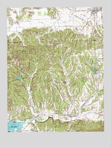
Morgantown, IN USGS Topographic Map
Click on map above to begin viewing in our Map Viewer.

This topographic map contains these locations and features:
Feature Name Type Latitude Longitude GNIS ID View Map
Autumn LakeReservoirN39.3200°W86.2745°447701View Map
Autumn Lake DamDamN39.3198°W86.2717°447702View Map
Baker LakeReservoirN39.3262°W86.2815°448834View Map
Baker Lake DamDamN39.3250°W86.2808°448835View Map
Bardonner LakeReservoirN39.3367°W86.2683°447695View Map
Bardonner Lake DamDamN39.3367°W86.2683°447696View Map
Bear CreekStreamN39.3609°W86.2658°430627View Map
Bear CreekStreamN39.2642°W86.3419°430618View Map
Bear Creek ChurchChurchN39.2920°W86.3447°430641View Map
Bear LakeReservoirN39.3118°W86.3562°448561View Map
Bear Lake DamDamN39.3117°W86.3533°448560View Map
Bear Lodge LakeReservoirN39.2931°W86.3334°447687View Map
Bear Lodge Lake DamDamN39.2934°W86.3333°447688View Map
Bear WallowPopulated PlaceN39.3237°W86.3689°452017View Map
Beech Grove ChurchChurchN39.3342°W86.2969°430725View Map
Bell CreekStreamN39.2767°W86.2930°430760View Map
Big Thunder CreekStreamN39.2892°W86.2583°431070View Map
Boles - Williams CemeteryCemeteryN39.3715°W86.2750°446064View Map
Brier CreekStreamN39.2650°W86.3255°431522View Map
Camp CreekStreamN39.3573°W86.3683°432023View Map
Carmel RidgeRidgeN39.2942°W86.3122°432150View Map
Cooks HillSummitN39.3300°W86.3144°432923View Map
CorneliusPopulated PlaceN39.2998°W86.2980°432979View Map
Cottonwood ChurchChurchN39.2989°W86.2986°433023View Map
Crooked CreekStreamN39.3645°W86.2911°433158View Map
Dunnaway CreekStreamN39.2712°W86.2808°433798View Map
Echo LakeReservoirN39.2513°W86.2860°433991View Map
Edward Lewis Lake DamLakeN39.2858°W86.3027°447759View Map
Fineburg LakeReservoirN39.3250°W86.3050°447697View Map
Fineburg Lake DamDamN39.3250°W86.3050°447698View Map
FruitdalePopulated PlaceN39.3220°W86.2578°434882View Map
Fruitdale Volunteer Fire DepartmentBuildingN39.2711°W86.2501°2625642View Map
Gallahue LakeReservoirN39.3040°W86.3588°447075View Map
Gallahue Lake DamDamN39.3023°W86.3580°448909View Map
Gallahue Valley CampParkN39.3034°W86.3558°434927View Map
HelmsburgPopulated PlaceN39.2653°W86.2928°435997View Map
Helmsburg Elementary SchoolSchoolN39.2723°W86.2892°447485View Map
Hickman's Trailer ParkPopulated PlaceN39.3731°W86.2614°2515666View Map
Hoppers BranchStreamN39.2689°W86.2639°436473View Map
Hungry Acres LakeReservoirN39.3275°W86.3203°447693View Map
Hungry Acres Lake DamDamN39.3267°W86.3200°447694View Map
Indian Trace CreekStreamN39.3559°W86.3180°436783View Map
Jack CreekStreamN39.2914°W86.3469°436876View Map
Jackson Township Volunteer Fire DepartmentBuildingN39.2639°W86.2924°2625612View Map
Kelly LakeReservoirN39.3232°W86.3154°448836View Map
Kelly Lake DamDamN39.3234°W86.3167°448837View Map
Kenstin Manor Airport (historical)AirportN39.2625°W86.2875°449198View Map
Kirkofer LakeReservoirN39.2992°W86.3403°447455View Map
Kirkofer Lake DamDamN39.2987°W86.3414°447456View Map
Lake LaSalleReservoirN39.3117°W86.2625°452058View Map
Lake Lasalle DamDamN39.3081°W86.2600°447260View Map
Lick CreekStreamN39.2612°W86.3014°437861View Map
Linger Longer LakeReservoirN39.2694°W86.3080°437959View Map
Long RunStreamN39.3648°W86.2814°438282View Map
Lutheran Church Camp DamDamN39.2795°W86.3450°447201View Map
Lutheran Hills LakeReservoirN39.2797°W86.3435°447202View Map
MahalasvillePopulated PlaceN39.3603°W86.3628°438476View Map
Merriman LakeReservoirN39.3215°W86.2900°447699View Map
Merriman Lake DamDamN39.3209°W86.2900°447700View Map
Midway ChurchChurchN39.3156°W86.2569°439128View Map
MorgantownPopulated PlaceN39.3714°W86.2611°439438View Map
Morgantown Fire DepartmentBuildingN39.3739°W86.2572°2625818View Map
Morgantown Police DepartmentBuildingN39.3715°W86.2621°2758109View Map
Mount Pleasant ChurchChurchN39.3673°W86.3742°439680View Map
Mount Zion ChurchChurchN39.3489°W86.3355°439760View Map
NeedmorePopulated PlaceN39.2512°W86.3397°439974View Map
North Fork Beanblossom CreekStreamN39.2667°W86.2805°440247View Map
Oak RidgeRidgeN39.2962°W86.2880°440448View Map
Oak Ridge ChurchChurchN39.2848°W86.2878°440453View Map
Oliver CreekStreamN39.3620°W86.3092°440653View Map
Opossum RunStreamN39.2928°W86.3717°447924View Map
Pike CreekStreamN39.3603°W86.3000°441131View Map
Plum CreekStreamN39.2614°W86.3464°441364View Map
Point IdalawnPopulated PlaceN39.2606°W86.3689°441390View Map
Rorack LakeReservoirN39.3384°W86.2517°447689View Map
Rorack Lake DamDamN39.3384°W86.2517°447690View Map
Shady Oaks LakeReservoirN39.3063°W86.2715°447685View Map
Shady Oaks Lake DamDamN39.3034°W86.2717°447686View Map
Stockton LakeReservoirN39.3493°W86.3484°448773View Map
Stockton Lake DamDamN39.3484°W86.3500°448774View Map
Town of MorgantownCivilN39.3729°W86.2586°2396781View Map
Township of JacksonCivilN39.2835°W86.3060°453433View Map
TrevlacPopulated PlaceN39.2656°W86.3369°444872View Map
Vaughn HollowValleyN39.2509°W86.3674°445236View Map
WaycrossPopulated PlaceN39.3037°W86.3442°445573View Map
Weaver LakeReservoirN39.3375°W86.3243°447691View Map
Weaver Lake DamDamN39.3375°W86.3250°447692View Map
Zupancic FieldAirportN39.3548°W86.3092°2677011View Map

Note: Coordinates in the location and feature list above are referenced to NAD83 datum.


Copyright (C) 2008-2024 Ryan Niemi / Sunset Dynamics ... All Rights Reserved