TopoQuest Logo
Do you find TopoQuest useful?
Help keep TopoQuest running and adding new maps/features by donating!
Bitcoin:  19c7KJd3qBynnjoSw5npx9KScwjBe4ifkT
Litecoin:  LXs6TkuXGGXo1vDsWCkWVdjQX94eUKd6ui
Home View Maps Find Maps Find Places Resources & Links


Mashulaville, Mississippi Topographic Map

USGS Map Title: Mashulaville, MS
USGS Map MRC: 33088A6
DRG (GeoTIFF) Download: o33088a6.tif


Neighboring USGS Topographic Map Quads:


  Barge Lake, MS  
33088B7
 

  Lynn Creek, MS  
33088B6
 

  Brooksville, MS  
33088B5
 

  Fearns Springs, MS  
33088A7
 

  Mashulaville, MS  
33088A6
 

  Macon, MS  
33088A5
 

  Preston, MS  
32088H7
 

  Gholson, MS  
32088H6
 

  Shuqualak, MS  
32088H5


Map MRC Location:

N34°
W89°
N34°
W88°
H8 H7 H6 H5 H4 H3 H2 H1
G8 G7 G6 G5 G4 G3 G2 G1
F8 F7 F6 F5 F4 F3 F2 F1
E8 E7 E6 E5 E4 E3 E2 E1
D8 D7 D6 D5 D4 D3 D2 D1
C8 C7 C6 C5 C4 C3 C2 C1
B8 B7 B6 B5 B4 B3 B2 B1
A8 A7 A6 A5 A4 A3 A2 A1
N33°
W89°
N33°
W88°

Mashulaville, MS USGS 1:24K Topographic Map Preview:
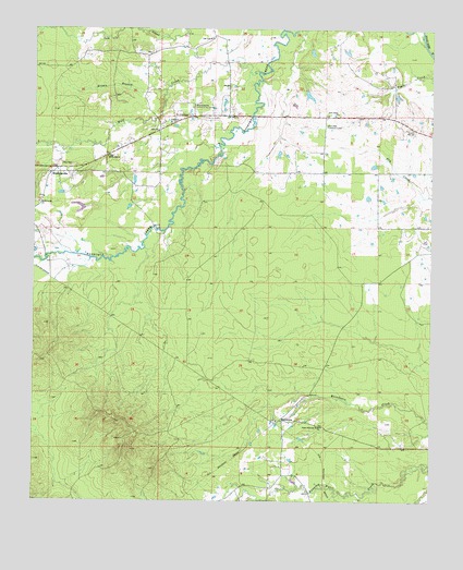
Mashulaville, MS USGS Topographic Map
Click on map above to begin viewing in our Map Viewer.

This topographic map contains these locations and features:
Feature Name Type Latitude Longitude GNIS ID View Map
Brown BranchStreamN33.1087°W88.7087°667613View Map
MacedoniaPopulated PlaceN33.0215°W88.6728°672982View Map
Macedonia CemeteryCemeteryN33.0212°W88.6737°710490View Map
Macedonia ChurchChurchN33.0212°W88.6734°710491View Map
MashulavillePopulated PlaceN33.0868°W88.7442°673218View Map
Mashulaville ChurchChurchN33.0787°W88.7487°673220View Map
Mashulaville Community CenterLocaleN33.1048°W88.6998°673221View Map
Mashulaville Volunteer Fire DepartmentBuildingN33.0899°W88.7317°2665809View Map
May CemeteryCemeteryN33.0890°W88.7414°673256View Map
May SpringPopulated PlaceN33.0932°W88.7237°689623View Map
Mount Moriah ChurchChurchN33.0912°W88.7270°674069View Map
Mount Olive CemeteryCemeteryN33.1021°W88.7014°674109View Map
Mount Olive ChurchChurchN33.1018°W88.6895°674142View Map
New Salem ChurchChurchN33.1026°W88.6545°674833View Map
Noxubee Lookout TowerTowerN33.0996°W88.6578°711282View Map
Oak Leaf ChurchChurchN33.1226°W88.6942°675087View Map
SEARAY Target Range ComplexMilitaryN33.0531°W88.6817°2512008View Map
Supervisor District 4CivilN33.0276°W88.6682°712010View Map
Upper Running Water ChurchChurchN33.0198°W88.6595°679157View Map
Wolf CreekStreamN33.1137°W88.6795°679812View Map

Note: Coordinates in the location and feature list above are referenced to NAD83 datum.


Copyright (C) 2008-2025 Ryan Niemi / Sunset Dynamics ... All Rights Reserved