TopoQuest Logo
Do you find TopoQuest useful?
Help keep TopoQuest running and adding new maps/features by donating!
Bitcoin:  19c7KJd3qBynnjoSw5npx9KScwjBe4ifkT
Litecoin:  LXs6TkuXGGXo1vDsWCkWVdjQX94eUKd6ui
Home View Maps Find Maps Find Places Resources & Links


Mathis, Texas Topographic Map

USGS Map Title: Mathis, TX
USGS Map MRC: 28097A7
DRG (GeoTIFF) Download: o28097a7.tif


Neighboring USGS Topographic Map Quads:


  Dinero, TX  
28097B8
 

  Tynan, TX  
28097B7
 

  Bullshead Creek, TX  
28097B6
 

  Sandia, TX  
28097A8
 

  Mathis, TX  
28097A7
 

  West Sinton, TX  
28097A6
 

  Orange Grove, TX  
27097H8
 

  San Patricio, TX  
27097H7
 

  Edroy, TX  
27097H6


Map MRC Location:

N29°
W98°
N29°
W97°
H8 H7 H6 H5 H4 H3 H2 H1
G8 G7 G6 G5 G4 G3 G2 G1
F8 F7 F6 F5 F4 F3 F2 F1
E8 E7 E6 E5 E4 E3 E2 E1
D8 D7 D6 D5 D4 D3 D2 D1
C8 C7 C6 C5 C4 C3 C2 C1
B8 B7 B6 B5 B4 B3 B2 B1
A8 A7 A6 A5 A4 A3 A2 A1
N28°
W98°
N28°
W97°

Mathis, TX USGS 1:24K Topographic Map Preview:
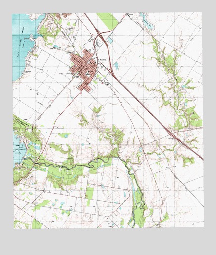
Mathis, TX USGS Topographic Map
Click on map above to begin viewing in our Map Viewer.

This topographic map contains these locations and features:
Feature Name Type Latitude Longitude GNIS ID View Map
Bayou CreekStreamN28.0386°W97.8011°1330166View Map
Cenzo Hill CemeteryCemeteryN28.1156°W97.8394°1332588View Map
Chalk HillSummitN28.1222°W97.8450°1332614View Map
City of MathisCivilN28.0909°W97.8170°2411049View Map
Clearwater CovePopulated PlaceN28.0903°W97.8678°1332963View Map
Descanso Eterno CemeteryCemeteryN28.0906°W97.8342°1334280View Map
Edgewater EstatesPopulated PlaceN28.0972°W97.8643°2413625View Map
Edgewater Estates Census Designated PlaceCensusN28.0969°W97.8650°2586925View Map
Edgewater Estates Number 1 ColoniaPopulated PlaceN28.0972°W97.8653°2011307View Map
Edgewater Estates Number 3 ColoniaPopulated PlaceN28.0972°W97.8633°2011308View Map
Edgewater-Paisano Census Designated Place (historical)CensusN28.0961°W97.8631°1852701View Map
First Baptist ChurchChurchN28.0914°W97.8294°2023646View Map
Gorbet Estates ColoniaPopulated PlaceN28.0233°W97.8692°2011519View Map
Hardin Elementary SchoolSchoolN28.0908°W97.8256°2008875View Map
Hardin SchoolSchoolN28.0903°W97.8253°1337339View Map
Harmony Assembly of God ChurchChurchN28.0939°W97.8306°2023643View Map
Hidden AcresPopulated PlaceN28.1153°W97.8575°1337692View Map
Hidden Acres ColoniaPopulated PlaceN28.1203°W97.8553°2011316View Map
Jack Green HollowValleyN28.1208°W97.8581°1338552View Map
La FrutaPopulated PlaceN28.0408°W97.8594°1378539View Map
La Ponderosa ColoniaPopulated PlaceN28.1233°W97.8622°2011323View Map
Lake Corpus ChristiReservoirN28.0436°W97.8647°1861919View Map
Lakeshore Gardens-Hidden Acres Census Designated PlaceCensusN28.1234°W97.8653°2408561View Map
LakesidePopulated PlaceN28.1045°W97.8612°2413643View Map
Lakewood HeightsPopulated PlaceN28.1028°W97.8633°1388188View Map
MathisPopulated PlaceN28.0945°W97.8281°1341072View Map
Mathis CemeteryCemeteryN28.0892°W97.8342°1341073View Map
Mathis City HallBuildingN28.0920°W97.8249°2753471View Map
Mathis DivisionCivilN28.0513°W97.7677°1938975View Map
Mathis Emergency Medical ServicesBuildingN28.0953°W97.8273°2655977View Map
Mathis High SchoolSchoolN28.0838°W97.8131°2008880View Map
Mathis Intermediate SchoolSchoolN28.0906°W97.8253°2008881View Map
Mathis Police DepartmentBuildingN28.0939°W97.8249°2335037View Map
Mathis Post OfficePost OfficeN28.0927°W97.8276°2732016View Map
Mathis Volunteer Fire and EMS DepartmentBuildingN28.0922°W97.8250°2334637View Map
Mathis Volunteer Fire DepartmentBuildingN28.0940°W97.8247°2334254View Map
McCraw Junior High SchoolSchoolN28.0898°W97.8261°2008882View Map
Methodist Parsonage First United ChurchChurchN28.0897°W97.8278°2023570View Map
Mount Pisgah Baptist ChurchChurchN28.0964°W97.8225°2023557View Map
New LakeReservoirN28.0821°W97.7624°1864913View Map
New Lake DamDamN28.0820°W97.7636°1864912View Map
Old LakeReservoirN28.0717°W97.7616°1864915View Map
Old Lake DamDamN28.0703°W97.7619°1864914View Map
Paisano Park Census Designated PlaceCensusN28.0951°W97.8592°2586968View Map
Paisano Park ColoniaPopulated PlaceN28.0953°W97.8603°2011291View Map
Paiz ParkParkN28.1008°W97.8306°2029662View Map
Point LomaPopulated PlaceN28.1114°W97.8633°1344299View Map
Saint Michaels Episcopal ChurchChurchN28.1022°W97.8239°2023565View Map
Saint Pius SchoolSchoolN28.0845°W97.8278°1346110View Map
San Patricio County Constable's Office Precinct 5BuildingN28.1014°W97.8282°2739442View Map
Sandia Census Designated PlaceCensusN28.0199°W97.8701°2409270View Map
Sandia Gardens ColoniaPopulated PlaceN28.0222°W97.8742°2011470View Map
Sandia Mobile Home Park ColoniaPopulated PlaceN28.0272°W97.8183°2011416View Map
Shady Acres ColoniaPopulated PlaceN28.0283°W97.8433°2011418View Map
Shawondasse CampLocaleN28.0358°W97.8717°1346997View Map
Sixmile CreekStreamN28.0414°W97.8058°1347191View Map
Town of LakesideCivilN28.1031°W97.8611°2412866View Map
Vahlasing Lake DamDamN28.0970°W97.7753°1862398View Map
VahlsingPopulated PlaceN28.1239°W97.8000°1379200View Map
Vahlsing LakeReservoirN28.1197°W97.7866°1349144View Map
Weber Hardin Elementary SchoolSchoolN28.0903°W97.8266°2008894View Map
Weber SchoolSchoolN28.0900°W97.8264°1349593View Map
Wesley E Seale DamDamN28.0420°W97.8692°1349667View Map
Wesley E Seale DamDamN28.0420°W97.8653°1861918View Map

Note: Coordinates in the location and feature list above are referenced to NAD83 datum.


Copyright (C) 2008-2025 Ryan Niemi / Sunset Dynamics ... All Rights Reserved