TopoQuest Logo
Do you find TopoQuest useful?
Help keep TopoQuest running and adding new maps/features by donating!
Bitcoin:  19c7KJd3qBynnjoSw5npx9KScwjBe4ifkT
Litecoin:  LXs6TkuXGGXo1vDsWCkWVdjQX94eUKd6ui
Home View Maps Find Maps Find Places Resources & Links


San Patricio, Texas Topographic Map

USGS Map Title: San Patricio, TX
USGS Map MRC: 27097H7
DRG (GeoTIFF) Download: o27097h7.tif


Neighboring USGS Topographic Map Quads:


  Sandia, TX  
28097A8
 

  Mathis, TX  
28097A7
 

  West Sinton, TX  
28097A6
 

  Orange Grove, TX  
27097H8
 

  San Patricio, TX  
27097H7
 

  Edroy, TX  
27097H6
 

  Agua Dulce, TX  
27097G8
 

  Banquete, TX  
27097G7
 

  Robstown, TX  
27097G6


Map MRC Location:

N28°
W98°
N28°
W97°
H8 H7 H6 H5 H4 H3 H2 H1
G8 G7 G6 G5 G4 G3 G2 G1
F8 F7 F6 F5 F4 F3 F2 F1
E8 E7 E6 E5 E4 E3 E2 E1
D8 D7 D6 D5 D4 D3 D2 D1
C8 C7 C6 C5 C4 C3 C2 C1
B8 B7 B6 B5 B4 B3 B2 B1
A8 A7 A6 A5 A4 A3 A2 A1
N27°
W98°
N27°
W97°

San Patricio, TX USGS 1:24K Topographic Map Preview:
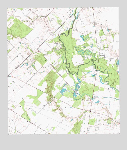
San Patricio, TX USGS Topographic Map
Click on map above to begin viewing in our Map Viewer.

This topographic map contains these locations and features:
Feature Name Type Latitude Longitude GNIS ID View Map
BluntzerPopulated PlaceN27.8972°W97.7831°1378024View Map
City of San PatricioCivilN27.9772°W97.7765°2411802View Map
Dismero SpringsSpringN27.9086°W97.7586°1998423View Map
EscondidasPopulated PlaceN27.9472°W97.8207°2652329View Map
Fort LipantitlanLocaleN27.9647°W97.8178°1336057View Map
Glasscock LakeReservoirN27.9770°W97.7586°1864917View Map
Glasscock Lake DamDamN27.9770°W97.7586°1864916View Map
J A Knolle Field (historical)AirportN27.9900°W97.8194°1387489View Map
James McGloin HomesteadLocaleN27.9731°W97.7917°2032094View Map
Javelin CreekStreamN27.9720°W97.8167°1338663View Map
KnollePopulated PlaceN27.9742°W97.8244°1339194View Map
Lain CreekStreamN27.9870°W97.8469°1339476View Map
Leon CreekStreamN27.8764°W97.8675°1339817View Map
Lilly LakeLakeN27.9328°W97.7786°1339922View Map
Nueces County Emergency Service District 4BuildingN27.8983°W97.7833°2655871View Map
Nueces County Rural Fire Protection District 4BuildingN27.8983°W97.7833°2334632View Map
Old Ranch CemeteryCemeteryN27.9872°W97.8275°1343200View Map
Old San Patricio CemeteryCemeteryN27.9600°W97.7617°1343224View Map
Round LakeReservoirN27.9705°W97.7910°1345669View Map
Round Lake SpringsSpringN27.9753°W97.7753°1998368View Map
San PatricioPopulated PlaceN27.9545°W97.7719°1346436View Map
San Patricio City HallBuildingN27.9520°W97.7732°2753827View Map
San Patricio International AirportAirportN27.9832°W97.7913°1387503View Map
Sandy HollowPopulated PlaceN27.9591°W97.8186°2652328View Map
Sandy Hollow CreekStreamN27.9586°W97.8106°1346600View Map
Sandy Hollow-Escondidas Census Designated PlaceCensusN27.9265°W97.7923°2409271View Map
Willow LakeReservoirN27.9775°W97.7625°1350199View Map

Note: Coordinates in the location and feature list above are referenced to NAD83 datum.


Copyright (C) 2008-2024 Ryan Niemi / Sunset Dynamics ... All Rights Reserved