TopoQuest Logo
Do you find TopoQuest useful?
Help keep TopoQuest running and adding new maps/features by donating!
Bitcoin:  19c7KJd3qBynnjoSw5npx9KScwjBe4ifkT
Litecoin:  LXs6TkuXGGXo1vDsWCkWVdjQX94eUKd6ui
Home View Maps Find Maps Find Places Resources & Links


Sandia, Texas Topographic Map

USGS Map Title: Sandia, TX
USGS Map MRC: 28097A8
DRG (GeoTIFF) Download: o28097a8.tif


Neighboring USGS Topographic Map Quads:


  Crater Ridge, TX  
28098B1
 

  Dinero, TX  
28097B8
 

  Tynan, TX  
28097B7
 

  Midway, TX  
28098A1
 

  Sandia, TX  
28097A8
 

  Mathis, TX  
28097A7
 

  San Diego NE, TX  
27098H1
 

  Orange Grove, TX  
27097H8
 

  San Patricio, TX  
27097H7


Map MRC Location:

N29°
W98°
N29°
W97°
H8 H7 H6 H5 H4 H3 H2 H1
G8 G7 G6 G5 G4 G3 G2 G1
F8 F7 F6 F5 F4 F3 F2 F1
E8 E7 E6 E5 E4 E3 E2 E1
D8 D7 D6 D5 D4 D3 D2 D1
C8 C7 C6 C5 C4 C3 C2 C1
B8 B7 B6 B5 B4 B3 B2 B1
A8 A7 A6 A5 A4 A3 A2 A1
N28°
W98°
N28°
W97°

Sandia, TX USGS 1:24K Topographic Map Preview:
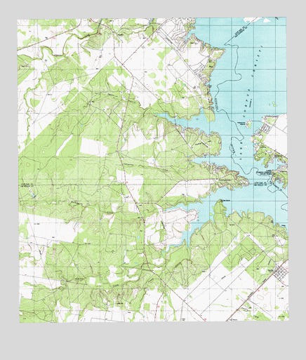
Sandia, TX USGS Topographic Map
Click on map above to begin viewing in our Map Viewer.

This topographic map contains these locations and features:
Feature Name Type Latitude Longitude GNIS ID View Map
Arrowhead AirportAirportN28.1192°W97.9334°1387033View Map
Barbone CreekStreamN28.0470°W97.9219°1330032View Map
Beldon HollowValleyN28.0856°W97.9351°1330357View Map
Camp MerrillLocaleN28.0008°W97.9039°1381010View Map
Carmel HillsSummitN28.0753°W97.9153°1332171View Map
Casa BlancaPopulated PlaceN28.0008°W97.9039°1381014View Map
Charquitas CreekStreamN28.0661°W97.9181°1332695View Map
Hobbs HollowValleyN28.0341°W97.9210°1337857View Map
Hodges Addition ColoniaPopulated PlaceN28.0164°W97.8764°2011474View Map
John L Norris ColoniaPopulated PlaceN28.0264°W97.8814°2011433View Map
LagartoPopulated PlaceN28.1195°W97.9556°1339448View Map
Lagarto Volunteer Fire DepartmentBuildingN28.1173°W97.9574°2334288View Map
Lake CityPopulated PlaceN28.0795°W97.8858°1388616View Map
Lake Corpus Christi State ParkParkN28.0620°W97.8767°1339491View Map
Mesquite IslandIslandN28.0811°W97.8931°1341415View Map
Millers BluffCliffN28.0928°W97.9111°1341674View Map
Norris Tract Number 2 ColoniaPopulated PlaceN28.0333°W97.8903°2011450View Map
Old Casa Blanca FortLocaleN28.0497°W97.9067°1343124View Map
Penitas CreekStreamN28.0345°W97.9239°1375411View Map
Pernitas PointCapeN28.0588°W97.9038°2724813View Map
Pernitas PointPopulated PlaceN28.0600°W97.9047°1343864View Map
Rozypal Estates ColoniaPopulated PlaceN28.0522°W97.9372°2011466View Map
SandiaPopulated PlaceN28.0225°W97.8794°1346565View Map
Sandia Ambulance ServicesBuildingN28.0229°W97.8781°2334276View Map
Sandia Fire DepartmentBuildingN28.0230°W97.8780°2551029View Map
Sandia Post OfficePost OfficeN28.0216°W97.8799°2732020View Map
Town of Lake CityCivilN28.0822°W97.8826°2412864View Map
Village of Pernitas Point (historical)CivilN28.0599°W97.9039°2413577View Map
Wade CemeteryCemeteryN28.0017°W97.9256°1349337View Map
Wade RanchLocaleN28.0353°W97.8806°1349340View Map
Wadeside Addition ColoniaPopulated PlaceN28.0222°W97.8814°2011423View Map
Zephyr EncampmentLocaleN28.1211°W97.9206°1350732View Map

Note: Coordinates in the location and feature list above are referenced to NAD83 datum.


Copyright (C) 2008-2025 Ryan Niemi / Sunset Dynamics ... All Rights Reserved