TopoQuest Logo
Do you find TopoQuest useful?
Help keep TopoQuest running and adding new maps/features by donating!
Bitcoin:  19c7KJd3qBynnjoSw5npx9KScwjBe4ifkT
Litecoin:  LXs6TkuXGGXo1vDsWCkWVdjQX94eUKd6ui
Home View Maps Find Maps Find Places Resources & Links


Matthews, North Carolina Topographic Map

USGS Map Title: Matthews, NC
USGS Map MRC: 35080A6
DRG (GeoTIFF) Download: o35080a6.tif


Neighboring USGS Topographic Map Quads:


  Charlotte East, NC  
35080B7
 

  Mint Hill, NC  
35080B6
 

  Midland, NC  
35080B5
 

  Weddington, NC  
35080A7
 

  Matthews, NC  
35080A6
 

  Bakers, NC  
35080A5
 

  Catawba NE, SC  
34080H7
 

  Waxhaw, NC  
34080H6
 

  Monroe, NC  
34080H5


Map MRC Location:

N36°
W81°
N36°
W80°
H8 H7 H6 H5 H4 H3 H2 H1
G8 G7 G6 G5 G4 G3 G2 G1
F8 F7 F6 F5 F4 F3 F2 F1
E8 E7 E6 E5 E4 E3 E2 E1
D8 D7 D6 D5 D4 D3 D2 D1
C8 C7 C6 C5 C4 C3 C2 C1
B8 B7 B6 B5 B4 B3 B2 B1
A8 A7 A6 A5 A4 A3 A2 A1
N35°
W81°
N35°
W80°

Matthews, NC USGS 1:24K Topographic Map Preview:
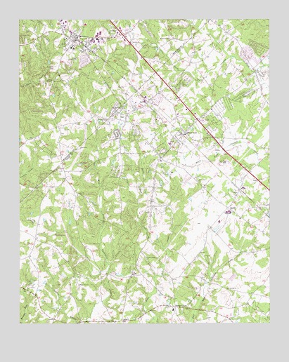
Matthews, NC USGS Topographic Map
Click on map above to begin viewing in our Map Viewer.

This topographic map contains these locations and features:
Feature Name Type Latitude Longitude GNIS ID View Map
Antioch Baptist Church CemeteryCemeteryN35.0526°W80.7206°2778862View Map
Antioch ChurchChurchN35.0532°W80.7206°980218View Map
Bethel ChurchChurchN35.0529°W80.6417°981117View Map
Center ChurchChurchN35.0204°W80.6931°982921View Map
Charlotte Plastics Lake Dam Number TwoDamN35.0435°W80.6265°998340View Map
Charlotte Plastics Lake Number TwoReservoirN35.0447°W80.6254°998339View Map
Club View AcresPopulated PlaceN35.1138°W80.7059°1001236View Map
Conder CemeteryCemeteryN35.0701°W80.6466°2778859View Map
David W Butler High SchoolSchoolN35.1203°W80.6931°1984517View Map
Davis Mine CreekStreamN35.0310°W80.6767°984011View Map
Depot Shopping CenterLocaleN35.1174°W80.7206°1007933View Map
East Woodforest ChurchChurchN35.0888°W80.6984°984546View Map
Eastern ChurchChurchN35.1157°W80.6926°984552View Map
Fox RunPopulated PlaceN35.0157°W80.7295°1002223View Map
Fullwood Plaza Shopping CenterLocaleN35.1188°W80.6959°1007280View Map
GatewoodPopulated PlaceN35.0282°W80.7228°1002224View Map
Goodman ParkParkN35.1054°W80.7312°985803View Map
Gordonville ChurchChurchN35.0146°W80.6459°985836View Map
Hartis Grove Baptist Church CemeteryCemeteryN35.0463°W80.6863°2778860View Map
Hartis Grove ChurchChurchN35.0485°W80.6831°986468View Map
Hemby BridgePopulated PlaceN35.1188°W80.6303°1867430View Map
Hoods (historical)Populated PlaceN35.1210°W80.6620°1001289View Map
Hudson Grove ChurchChurchN35.0274°W80.6862°987216View Map
Indian TrailPopulated PlaceN35.0768°W80.6692°987370View Map
Indian Trail CemeteryCemeteryN35.0731°W80.6663°2778858View Map
Indian Trail Post OfficePost OfficeN35.0807°W80.6595°2774289View Map
Indian Trail SchoolSchoolN35.0740°W80.6740°1002225View Map
Lake ParkPopulated PlaceN35.0863°W80.6351°1027626View Map
Maple Grove ChurchChurchN35.0160°W80.7201°989303View Map
MatthewsPopulated PlaceN35.1168°W80.7237°1021369View Map
Matthews Elementary SchoolSchoolN35.1126°W80.7226°1001320View Map
Matthews ParkPopulated PlaceN35.1021°W80.6934°1001321View Map
Matthews PlazaLocaleN35.1171°W80.6987°1001322View Map
Matthews Post OfficePost OfficeN35.1151°W80.7198°2774089View Map
Matthews Volunteer Fire DepartmentBuildingN35.1135°W80.7253°2638652View Map
Midway Park ChurchChurchN35.0588°W80.6606°989834View Map
Mount Harmony ChurchChurchN35.1171°W80.6748°990390View Map
Mount Harmony Church CemeteryCemeteryN35.1174°W80.6742°2778952View Map
Pleasant Plains Baptist Church CemeteryCemeteryN35.0837°W80.7054°2778861View Map
Pleasant Plains ChurchChurchN35.0843°W80.7062°992559View Map
Presbyterian Hospital MatthewsHospitalN35.1199°W80.7139°1984467View Map
Providence (historical)Populated PlaceN35.1013°W80.7184°1001371View Map
Providence WoodsPopulated PlaceN35.0501°W80.7434°1002226View Map
Rain ForestPopulated PlaceN35.0574°W80.7026°1002227View Map
Red HillSummitN35.0665°W80.6484°993106View Map
Siler ChurchChurchN35.0015°W80.6973°994798View Map
Simfield ChurchChurchN35.0724°W80.7192°994829View Map
Southminister WoodsPopulated PlaceN35.0946°W80.7206°1001407View Map
StallingsPopulated PlaceN35.0907°W80.6862°1022769View Map
Stallings Police DepartmentBuildingN35.0875°W80.6941°2769938View Map
Stallings Volunteer Fire Department Station 20BuildingN35.0651°W80.6743°2638141View Map
StoutsPopulated PlaceN35.0554°W80.6395°1022812View Map
Sun Valley High SchoolSchoolN35.0463°W80.6453°995695View Map
Sun Valley Middle SchoolSchoolN35.0449°W80.6453°1002228View Map
Town of Hemby BridgeCivilN35.1058°W80.6259°2405815View Map
Town of Indian TrailCivilN35.0698°W80.6453°2405887View Map
Town of MatthewsCivilN35.1195°W80.7101°2406108View Map
Town of StallingsCivilN35.1080°W80.6607°2407395View Map
Town of WeddingtonCivilN35.0227°W80.7384°2406850View Map
Township 5-ProvidenceCivilN35.1067°W80.7488°1026934View Map
Township of VanceCivilN35.0792°W80.6496°1027249View Map
Union Emergency Medical ServicesBuildingN35.0718°W80.6813°2720449View Map
Village of Lake ParkCivilN35.0848°W80.6348°2407488View Map
Village of Wesley ChapelCivilN35.0055°W80.6682°2407569View Map
Water OakPopulated PlaceN35.0399°W80.7140°1002229View Map
Wellington WoodsPopulated PlaceN35.0374°W80.6934°1002230View Map
Wesley ChapelPopulated PlaceN35.0071°W80.6745°1023157View Map
Wesley Chapel SchoolSchoolN35.0060°W80.6726°1002232View Map
Wesley Chapel United Methodist ChurchChurchN35.0045°W80.6723°2743984View Map
Wesley Chapel Volunteer Fire Department Station 43BuildingN35.0359°W80.7432°2638997View Map
White OakPopulated PlaceN35.0238°W80.7412°1002231View Map
Windrow BranchStreamN35.1100°W80.6439°2704670View Map

Note: Coordinates in the location and feature list above are referenced to NAD83 datum.


Copyright (C) 2008-2025 Ryan Niemi / Sunset Dynamics ... All Rights Reserved