TopoQuest Logo
Do you find TopoQuest useful?
Help keep TopoQuest running and adding new maps/features by donating!
Bitcoin:  19c7KJd3qBynnjoSw5npx9KScwjBe4ifkT
Litecoin:  LXs6TkuXGGXo1vDsWCkWVdjQX94eUKd6ui
Home View Maps Find Maps Find Places Resources & Links


McConnell, Tennessee Topographic Map

USGS Map Title: McConnell, TN
USGS Map MRC: 36088D7
DRG (GeoTIFF) Download: o36088d7.tif


Neighboring USGS Topographic Map Quads:


  Crutchfield, KY  
36088E8
 

  Water Valley, KY  
36088E7
 

  Cuba, KY  
36088E6
 

  Harris, TN  
36088D8
 

  McConnell, TN  
36088D7
 

  Latham, TN  
36088D6
 

  Gardner, TN  
36088C8
 

  Martin, TN  
36088C7
 

  Dresden, TN  
36088C6


Map MRC Location:

N37°
W89°
N37°
W88°
H8 H7 H6 H5 H4 H3 H2 H1
G8 G7 G6 G5 G4 G3 G2 G1
F8 F7 F6 F5 F4 F3 F2 F1
E8 E7 E6 E5 E4 E3 E2 E1
D8 D7 D6 D5 D4 D3 D2 D1
C8 C7 C6 C5 C4 C3 C2 C1
B8 B7 B6 B5 B4 B3 B2 B1
A8 A7 A6 A5 A4 A3 A2 A1
N36°
W89°
N36°
W88°

McConnell, TN USGS 1:24K Topographic Map Preview:
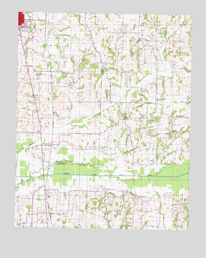
McConnell, TN USGS Topographic Map
Click on map above to begin viewing in our Map Viewer.

This topographic map contains these locations and features:
Feature Name Type Latitude Longitude GNIS ID View Map
Bell Meade SubdivisionPopulated PlaceN36.4759°W88.8589°1311815View Map
Camp GroundPopulated PlaceN36.3940°W88.7887°1279389View Map
Camp GroundPopulated PlaceN36.3953°W88.7889°1312589View Map
Camp Ground CemeteryCemeteryN36.3959°W88.7923°1322280View Map
Camp Ground CreekStreamN36.4056°W88.7795°1279391View Map
Chestnut GladePopulated PlaceN36.4481°W88.7751°1647632View Map
Chestnut Glade SchoolSchoolN36.4501°W88.7742°1280380View Map
Commissioner District 8CivilN36.3772°W88.7807°2464705View Map
Cypress CreekStreamN36.4078°W88.7506°1281934View Map
Ferrell CemeteryCemeteryN36.4331°W88.8731°1284224View Map
Harold Muzzall DamDamN36.4901°W88.8017°1302627View Map
Harold Muzzall LakeReservoirN36.4902°W88.8010°1302628View Map
Hatlers Camp Ground Methodist ChurchChurchN36.3948°W88.7884°1322337View Map
Jones BranchStreamN36.4673°W88.7698°1289705View Map
Jones CreekStreamN36.4056°W88.8012°1289788View Map
McConnellPopulated PlaceN36.4228°W88.8517°1293179View Map
McConnell Baptist ChurchChurchN36.4223°W88.8484°1320475View Map
McFall CemeteryCemeteryN36.4934°W88.8503°1293276View Map
Mitchell CemeteryCemeteryN36.4306°W88.8281°1320477View Map
Moss CemeteryCemeteryN36.4292°W88.7931°1294497View Map
Mount Moriah CemeteryCemeteryN36.4859°W88.7878°1322383View Map
Mount Moriah ChurchChurchN36.4845°W88.7878°1294681View Map
New Hope Baptist ChurchChurchN36.4378°W88.7801°1295564View Map
New Hope CemeteryCemeteryN36.4370°W88.7801°1322391View Map
Obion ChapelChurchN36.3770°W88.8701°1296224View Map
Obion Chapel CemeteryCemeteryN36.3764°W88.8703°1322401View Map
Parish School (historical)SchoolN36.3906°W88.7584°1322411View Map
Pate CemeteryCemeteryN36.4528°W88.8531°1320485View Map
Pounds CemeteryCemeteryN36.3762°W88.7889°1298377View Map
Roach CemeteryCemeteryN36.4498°W88.8653°1320492View Map
Rucker CemeteryCemeteryN36.4523°W88.8031°1300227View Map
RuthvillePopulated PlaceN36.4387°W88.7970°1300359View Map
Ruthville Baptist ChurchChurchN36.4390°W88.7964°1322435View Map
Sandy BranchStreamN36.4090°W88.7706°1300737View Map
Sandy Branch CemeteryCemeteryN36.4317°W88.7653°1322440View Map
Sandy Branch ChurchChurchN36.4312°W88.7645°1300742View Map
Sandy Branch School (historical)SchoolN36.4306°W88.7645°1322441View Map
Sawyer CemeteryCemeteryN36.4403°W88.7845°1300850View Map
Scott CemeteryCemeteryN36.4217°W88.8612°1300937View Map
Siler CemeteryCemeteryN36.4139°W88.8564°1320494View Map
South Fulton Baptist ChurchChurchN36.4953°W88.8720°1320496View Map
South Fulton Elementary SchoolSchoolN36.4853°W88.8739°1320498View Map
Thomas CemeteryCemeteryN36.4434°W88.7614°1272485View Map
Tommy CreekStreamN36.4062°W88.8076°1272758View Map
Trouble CreekStreamN36.4520°W88.7981°1272907View Map
Vowell BranchStreamN36.4056°W88.8101°1273500View Map
Walnut Grove BranchStreamN36.4362°W88.8356°1273717View Map
Walnut Grove CemeteryCemeteryN36.4570°W88.8370°1320509View Map
Walnut Grove ChurchChurchN36.4581°W88.8370°1326774View Map
Wolf CreekStreamN36.4178°W88.8737°1274952View Map

Note: Coordinates in the location and feature list above are referenced to NAD83 datum.


Copyright (C) 2008-2025 Ryan Niemi / Sunset Dynamics ... All Rights Reserved