TopoQuest Logo
Do you find TopoQuest useful?
Help keep TopoQuest running and adding new maps/features by donating!
Bitcoin:  19c7KJd3qBynnjoSw5npx9KScwjBe4ifkT
Litecoin:  LXs6TkuXGGXo1vDsWCkWVdjQX94eUKd6ui
Home View Maps Find Maps Find Places Resources & Links


Harris, Tennessee Topographic Map

USGS Map Title: Harris, TN
USGS Map MRC: 36088D8
DRG (GeoTIFF) Download: o36088d8.tif


Neighboring USGS Topographic Map Quads:


  Cayce, KY  
36089E1
 

  Crutchfield, KY  
36088E8
 

  Water Valley, KY  
36088E7
 

  Union City, TN  
36089D1
 

  Harris, TN  
36088D8
 

  McConnell, TN  
36088D7
 

  Rives, TN  
36089C1
 

  Gardner, TN  
36088C8
 

  Martin, TN  
36088C7


Map MRC Location:

N37°
W89°
N37°
W88°
H8 H7 H6 H5 H4 H3 H2 H1
G8 G7 G6 G5 G4 G3 G2 G1
F8 F7 F6 F5 F4 F3 F2 F1
E8 E7 E6 E5 E4 E3 E2 E1
D8 D7 D6 D5 D4 D3 D2 D1
C8 C7 C6 C5 C4 C3 C2 C1
B8 B7 B6 B5 B4 B3 B2 B1
A8 A7 A6 A5 A4 A3 A2 A1
N36°
W89°
N36°
W88°

Harris, TN USGS 1:24K Topographic Map Preview:
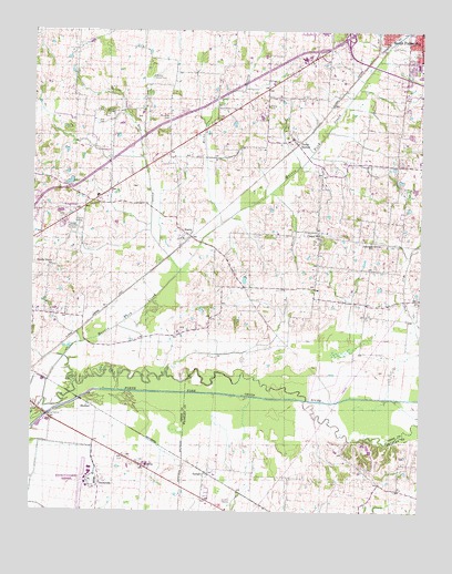
Harris, TN USGS Topographic Map
Click on map above to begin viewing in our Map Viewer.

This topographic map contains these locations and features:
Feature Name Type Latitude Longitude GNIS ID View Map
Arnold CemeteryCemeteryN36.4270°W88.9384°1320446View Map
ChambersPopulated PlaceN36.4534°W88.9848°1311823View Map
Chapel Hill CemeteryCemeteryN36.4453°W88.9070°1320452View Map
Chapel Hill ChurchChurchN36.4465°W88.9070°1280256View Map
City of South FultonCivilN36.4934°W88.8836°2405490View Map
City of South Fulton Wastewater Treatment PlantLocaleN36.4950°W88.8878°2677817View Map
Commissioner District 1CivilN36.4545°W88.8895°2464271View Map
Deer CreekStreamN36.4365°W88.9537°1282293View Map
Everett-Stewart Regional AirportAirportN36.3826°W88.9829°1301423View Map
Gill CemeteryCemeteryN36.4764°W88.9792°1285393View Map
HarrisPopulated PlaceN36.4467°W88.9498°1286943View Map
Hicks BranchStreamN36.4498°W88.9395°494157View Map
Johnson CemeteryCemeteryN36.4442°W88.8945°1320463View Map
Johnson Grove CemeteryCemeteryN36.4456°W88.8898°1320464View Map
Johnsons Grove ChurchChurchN36.4451°W88.8906°1289665View Map
Little Cypress CreekStreamN36.3751°W88.8901°1291468View Map
MidwayPopulated PlaceN36.3865°W88.9634°1293726View Map
Morris Slave CemeteryCemeteryN36.4878°W88.9617°1294437View Map
Murphey CemeteryCemeteryN36.4781°W88.9570°1295108View Map
Pierce CemeteryCemeteryN36.4806°W88.9242°1297424View Map
Pierce StationPopulated PlaceN36.4709°W88.9151°1297430View Map
Rankins CemeteryCemeteryN36.4573°W88.9137°1320487View Map
Richland CreekStreamN36.4048°W88.8753°1299364View Map
Shady Grove CemeteryCemeteryN36.4381°W88.9942°1326728View Map
Shady Grove ChurchChurchN36.4390°W88.9934°1301182View Map
ShofnerPopulated PlaceN36.4028°W88.9812°1314283View Map
South Fulton Division (historical)CensusN36.4809°W88.8817°1648899View Map
South Fulton Fire DepartmentBuildingN36.4915°W88.8767°2653645View Map
South Fulton High SchoolSchoolN36.4976°W88.8773°1320499View Map
South Fulton Industrial ParkLocaleN36.4934°W88.8945°1320500View Map
South Fulton Police DepartmentBuildingN36.4918°W88.8769°2765920View Map
South Fulton Shopping PlazaLocaleN36.4939°W88.8753°1320501View Map
SunnysidePopulated PlaceN36.3828°W88.9762°1314362View Map
TerrellPopulated PlaceN36.3851°W88.9440°1304048View Map
Terrell Post Office (historical)Post OfficeN36.3848°W88.9437°1651895View Map
Valentine CemeteryCemeteryN36.4148°W88.9403°1320508View Map
WALR-FM (Union City)TowerN36.4740°W88.9451°1640133View Map
White DamDamN36.4603°W88.9872°1302603View Map
White LakeReservoirN36.4606°W88.9882°1302602View Map

Note: Coordinates in the location and feature list above are referenced to NAD83 datum.


Copyright (C) 2008-2024 Ryan Niemi / Sunset Dynamics ... All Rights Reserved