TopoQuest Logo
Do you find TopoQuest useful?
Help keep TopoQuest running and adding new maps/features by donating!
Bitcoin:  19c7KJd3qBynnjoSw5npx9KScwjBe4ifkT
Litecoin:  LXs6TkuXGGXo1vDsWCkWVdjQX94eUKd6ui
Home View Maps Find Maps Find Places Resources & Links


Water Valley, Kentucky Topographic Map

USGS Map Title: Water Valley, KY
USGS Map MRC: 36088E7
DRG (GeoTIFF) Download: o36088e7.tif


Neighboring USGS Topographic Map Quads:


  Clinton, KY  
36088F8
 

  Dublin, KY  
36088F7
 

  Mayfield, KY  
36088F6
 

  Crutchfield, KY  
36088E8
 

  Water Valley, KY  
36088E7
 

  Cuba, KY  
36088E6
 

  Harris, TN  
36088D8
 

  McConnell, TN  
36088D7
 

  Latham, TN  
36088D6


Map MRC Location:

N37°
W89°
N37°
W88°
H8 H7 H6 H5 H4 H3 H2 H1
G8 G7 G6 G5 G4 G3 G2 G1
F8 F7 F6 F5 F4 F3 F2 F1
E8 E7 E6 E5 E4 E3 E2 E1
D8 D7 D6 D5 D4 D3 D2 D1
C8 C7 C6 C5 C4 C3 C2 C1
B8 B7 B6 B5 B4 B3 B2 B1
A8 A7 A6 A5 A4 A3 A2 A1
N36°
W89°
N36°
W88°

Water Valley, KY USGS 1:24K Topographic Map Preview:
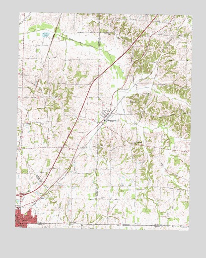
Water Valley, KY USGS Topographic Map
Click on map above to begin viewing in our Map Viewer.

This topographic map contains these locations and features:
Feature Name Type Latitude Longitude GNIS ID View Map
Bayou de Chien ChurchChurchN36.5789°W88.7801°486490View Map
Boaz ChapelChurchN36.5037°W88.8351°487594View Map
Boaz Chapel CemeteryCemeteryN36.5033°W88.8352°2775634View Map
Camp Beauregard CemeteryCemeteryN36.5747°W88.7927°488664View Map
City of Water Valley (historical)CivilN36.5688°W88.8108°2405684View Map
East BeelertonPopulated PlaceN36.5886°W88.8725°2743896View Map
EnonPopulated PlaceN36.5459°W88.8720°2743901View Map
Enon CemeteryCemeteryN36.5459°W88.8714°491788View Map
FelicianaPopulated PlaceN36.5498°W88.7914°507986View Map
FultonPopulated PlaceN36.5042°W88.8742°492615View Map
Jackson CreekStreamN36.5820°W88.8028°495118View Map
Lawrence CemeteryCemeteryN36.5176°W88.8138°496072View Map
Mount Zion CemeteryCemeteryN36.5761°W88.8488°2775542View Map
Mount Zion ChurchChurchN36.5759°W88.8487°498918View Map
Oak Grove Baptist ChurchChurchN36.5026°W88.7564°1296115View Map
Oak Grove CemeteryCemeteryN36.5014°W88.7562°1322397View Map
Pleasant Hill CemeteryCemeteryN36.5476°W88.8127°500840View Map
Pleasant Valley CemeteryCemeteryN36.6133°W88.8086°500919View Map
Pleasant View ChurchChurchN36.5681°W88.7514°500942View Map
RoperPopulated PlaceN36.6148°W88.8062°508968View Map
South Fork Bayou de ChienStreamN36.5759°W88.8031°503904View Map
Stephens LakeLakeN36.6121°W88.8556°504340View Map
Trinity ChurchChurchN36.5056°W88.8634°505502View Map
Water ValleyPopulated PlaceN36.5656°W88.8112°506261View Map
Water Valley Census Designated PlaceCensusN36.5688°W88.8108°2786573View Map
Wesley CemeteryCemeteryN36.5884°W88.8711°506392View Map

Note: Coordinates in the location and feature list above are referenced to NAD83 datum.


Copyright (C) 2008-2024 Ryan Niemi / Sunset Dynamics ... All Rights Reserved