TopoQuest Logo
Do you find TopoQuest useful?
Help keep TopoQuest running and adding new maps/features by donating!
Bitcoin:  19c7KJd3qBynnjoSw5npx9KScwjBe4ifkT
Litecoin:  LXs6TkuXGGXo1vDsWCkWVdjQX94eUKd6ui
Home View Maps Find Maps Find Places Resources & Links


Gardner, Tennessee Topographic Map

USGS Map Title: Gardner, TN
USGS Map MRC: 36088C8
DRG (GeoTIFF) Download: o36088c8.tif


Neighboring USGS Topographic Map Quads:


  Union City, TN  
36089D1
 

  Harris, TN  
36088D8
 

  McConnell, TN  
36088D7
 

  Rives, TN  
36089C1
 

  Gardner, TN  
36088C8
 

  Martin, TN  
36088C7
 

  Kenton, TN  
36089B1
 

  Rutherford, TN  
36088B8
 

  Greenfield, TN  
36088B7


Map MRC Location:

N37°
W89°
N37°
W88°
H8 H7 H6 H5 H4 H3 H2 H1
G8 G7 G6 G5 G4 G3 G2 G1
F8 F7 F6 F5 F4 F3 F2 F1
E8 E7 E6 E5 E4 E3 E2 E1
D8 D7 D6 D5 D4 D3 D2 D1
C8 C7 C6 C5 C4 C3 C2 C1
B8 B7 B6 B5 B4 B3 B2 B1
A8 A7 A6 A5 A4 A3 A2 A1
N36°
W89°
N36°
W88°

Gardner, TN USGS 1:24K Topographic Map Preview:
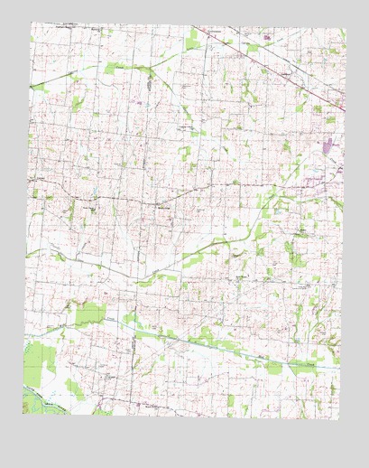
Gardner, TN USGS Topographic Map
Click on map above to begin viewing in our Map Viewer.

This topographic map contains these locations and features:
Feature Name Type Latitude Longitude GNIS ID View Map
Alamo CemeteryCemeteryN36.2623°W88.9673°2775765View Map
Alamo ChurchChurchN36.2626°W88.9670°1304783View Map
Alamo School (historical)SchoolN36.2628°W88.9662°1325947View Map
Beech Grove ChurchChurchN36.2528°W88.9470°1305063View Map
Bethel Baptist ChurchChurchN36.3092°W88.8912°1305147View Map
Callicott CemeteryCemeteryN36.3298°W88.9631°1279336View Map
Cane Creek ChurchChurchN36.3153°W88.9737°1279526View Map
CentralLocaleN36.3248°W88.9973°1280159View Map
Collier CemeteryCemeteryN36.3014°W88.9187°1280978View Map
Commissioner District 7CivilN36.3412°W88.8931°2464652View Map
Cypress Creek BottomFlatN36.3487°W88.9392°1312590View Map
Cypress Creek ChurchChurchN36.3417°W88.9353°1306250View Map
Dortch CemeteryCemeteryN36.2701°W88.9584°1282656View Map
GardnerPopulated PlaceN36.3584°W88.8981°1285157View Map
Gardner CemeteryCemeteryN36.3673°W88.8898°1322497View Map
Gardner CemeteryCemeteryN36.3723°W88.9159°1285158View Map
Gardner School (historical)SchoolN36.3590°W88.8926°1322498View Map
Hall CemeteryCemeteryN36.2745°W88.8934°1286579View Map
Hall CemeteryCemeteryN36.2776°W88.8987°1286580View Map
Harmony ChurchChurchN36.3728°W88.9723°1286900View Map
Hazelwood School (historical)SchoolN36.3459°W88.9606°1320460View Map
Henry CemeteryCemeteryN36.2784°W88.9478°1287441View Map
Henry CemeteryCemeteryN36.2842°W88.9842°1287442View Map
Holland CemeteryCemeteryN36.2773°W88.8806°1288058View Map
Hurt CemeteryCemeteryN36.3423°W88.9159°1288851View Map
Johnson CemeteryCemeteryN36.2778°W88.9917°1289573View Map
Jones CemeteryCemeteryN36.2989°W88.9028°1289753View Map
Limbs Store (historical)LocaleN36.2542°W88.9567°1322355View Map
McKinney CemeteryCemeteryN36.3156°W88.9334°1293376View Map
Mount PeliaPopulated PlaceN36.3176°W88.9495°1294732View Map
Mount Pelia CemeteryCemeteryN36.3173°W88.9520°1322385View Map
Mount Pelia High School (historical)SchoolN36.3226°W88.9348°1322386View Map
New Home ChurchChurchN36.2934°W88.9167°1295501View Map
Northwestern ChurchChurchN36.3723°W88.9306°1295978View Map
OFDBA Little Cypress Creek Lake NumberReservoirN36.3720°W88.8945°1302550View Map
Shaddtown CemeteryCemeteryN36.3559°W88.9403°1301148View Map
Simmons CemeteryCemeteryN36.2656°W88.9703°1270305View Map
Stanleys ChapelChurchN36.3745°W88.9840°1303799View Map
Stella Ruth Community CenterLocaleN36.2926°W88.8890°1271323View Map
Stella Ruth School (historical)SchoolN36.2926°W88.8892°1322455View Map
Sunnyside School (historical)SchoolN36.3742°W88.9790°1320503View Map
Taylor CemeteryCemeteryN36.3148°W88.9864°1272214View Map

Note: Coordinates in the location and feature list above are referenced to NAD83 datum.


Copyright (C) 2008-2024 Ryan Niemi / Sunset Dynamics ... All Rights Reserved