TopoQuest Logo
Do you find TopoQuest useful?
Help keep TopoQuest running and adding new maps/features by donating!
Bitcoin:  19c7KJd3qBynnjoSw5npx9KScwjBe4ifkT
Litecoin:  LXs6TkuXGGXo1vDsWCkWVdjQX94eUKd6ui
Home View Maps Find Maps Find Places Resources & Links


Bear Mountain, Oklahoma Topographic Map

USGS Map Title: Bear Mountain, OK
USGS Map MRC: 34094B8
DRG (GeoTIFF) Download: o34094b8.tif


Neighboring USGS Topographic Map Quads:


  Signal Mountain, OK  
34095C1
 

  Rocky Creek, OK  
34094C8
 

  Bethel, OK  
34094C7
 

  Alikchi, OK  
34095B1
 

  Bear Mountain, OK  
34094B8
 

  Old Glory Mountain, OK  
34094B7
 

  Wright City, OK  
34095A1
 

  Golden, OK  
34094A8
 

  Steel Junction, OK  
34094A7


Map MRC Location:

N35°
W95°
N35°
W94°
H8 H7 H6 H5 H4 H3 H2 H1
G8 G7 G6 G5 G4 G3 G2 G1
F8 F7 F6 F5 F4 F3 F2 F1
E8 E7 E6 E5 E4 E3 E2 E1
D8 D7 D6 D5 D4 D3 D2 D1
C8 C7 C6 C5 C4 C3 C2 C1
B8 B7 B6 B5 B4 B3 B2 B1
A8 A7 A6 A5 A4 A3 A2 A1
N34°
W95°
N34°
W94°

Bear Mountain, OK USGS 1:24K Topographic Map Preview:
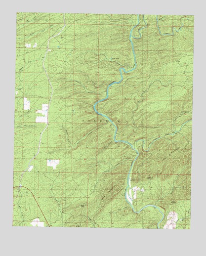
Bear Mountain, OK USGS Topographic Map
Click on map above to begin viewing in our Map Viewer.

This topographic map contains these locations and features:
Feature Name Type Latitude Longitude GNIS ID View Map
Bear MountainSummitN34.1565°W94.9258°1089916View Map
Black Sulphur HollowValleyN34.2085°W94.9340°1090212View Map
Burks HollowValleyN34.2176°W94.9194°1090715View Map
Burks SpringsSpringN34.2240°W94.9338°1090716View Map
Camp GloverLocaleN34.2179°W94.9216°1090860View Map
Caney CreekStreamN34.1379°W94.8994°1090910View Map
Caney MountainSummitN34.1407°W94.8899°1090924View Map
Carter CreekStreamN34.2379°W94.9194°1091005View Map
Cedar CreekStreamN34.1712°W94.9155°1091087View Map
Chinquapin MountainSummitN34.1529°W94.9144°1091308View Map
Cold SpringsSpringN34.1251°W94.9533°1091555View Map
Dierks CampLocaleN34.2207°W94.9219°1738079View Map
Grapevine MountainSummitN34.1562°W94.9033°1093325View Map
Lebow HollowValleyN34.1643°W94.9160°1094550View Map
Meat HollowValleyN34.1759°W94.9299°1095282View Map
North Carter CreekStreamN34.2465°W94.9013°1095928View Map
North Cedar CreekStreamN34.1823°W94.8872°1095931View Map
Shell Rock CreekStreamN34.1804°W94.9291°1097981View Map
Shorty Cox HollowValleyN34.2044°W94.9357°1098028View Map
Tidwell CreekStreamN34.1318°W94.8772°1098887View Map
Township of SulphurCivilN34.2459°W94.9349°1824687View Map
Whisky BranchStreamN34.1715°W94.9583°1099676View Map
Whisky HollowValleyN34.1385°W94.9174°1099684View Map
Wolf HollowValleyN34.1873°W94.9341°1099964View Map

Note: Coordinates in the location and feature list above are referenced to NAD83 datum.


Copyright (C) 2008-2025 Ryan Niemi / Sunset Dynamics ... All Rights Reserved