TopoQuest Logo
Do you find TopoQuest useful?
Help keep TopoQuest running and adding new maps/features by donating!
Bitcoin:  19c7KJd3qBynnjoSw5npx9KScwjBe4ifkT
Litecoin:  LXs6TkuXGGXo1vDsWCkWVdjQX94eUKd6ui
Home View Maps Find Maps Find Places Resources & Links


McCordsville, Indiana Topographic Map

USGS Map Title: McCordsville, IN
USGS Map MRC: 39085H8
DRG (GeoTIFF) Download: o39085h8.tif


Neighboring USGS Topographic Map Quads:


  Noblesville, IN  
40086A1
 

  Riverwood, IN  
40085A8
 

  Lapel, IN  
40085A7
 

  Fishers, IN  
39086H1
 

  McCordsville, IN  
39085H8
 

  Ingalls, IN  
39085H7
 

  Indianapolis East, IN  
39086G1
 

  Cumberland, IN  
39085G8
 

  Greenfield, IN  
39085G7


Map MRC Location:

N40°
W86°
N40°
W85°
H8 H7 H6 H5 H4 H3 H2 H1
G8 G7 G6 G5 G4 G3 G2 G1
F8 F7 F6 F5 F4 F3 F2 F1
E8 E7 E6 E5 E4 E3 E2 E1
D8 D7 D6 D5 D4 D3 D2 D1
C8 C7 C6 C5 C4 C3 C2 C1
B8 B7 B6 B5 B4 B3 B2 B1
A8 A7 A6 A5 A4 A3 A2 A1
N39°
W86°
N39°
W85°

McCordsville, IN USGS 1:24K Topographic Map Preview:
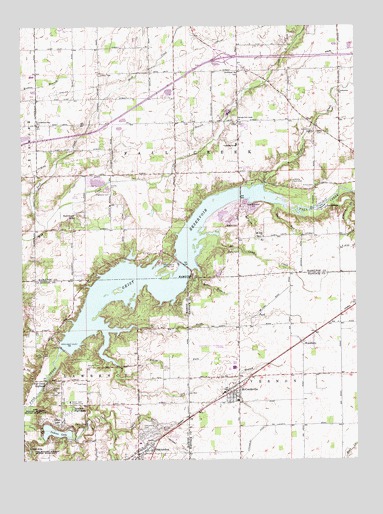
McCordsville, IN USGS Topographic Map
Click on map above to begin viewing in our Map Viewer.

This topographic map contains these locations and features:
Feature Name Type Latitude Longitude GNIS ID View Map
Arnett CemeteryCemeteryN39.9537°W85.8905°430269View Map
AshwoodPopulated PlaceN39.9803°W85.9783°2107248View Map
Bee Camp CreekStreamN39.9364°W85.9319°430703View Map
Bethlehem CemeteryCemeteryN39.9861°W85.9194°2101475View Map
Bethlehem ChurchChurchN39.9867°W85.9189°430982View Map
Billericay ParkParkN39.9733°W85.9669°2106824View Map
Bills BranchStreamN39.9286°W85.9330°431082View Map
Bills CemeteryCemeteryN39.9199°W85.9422°431083View Map
Bradford CourtPopulated PlaceN39.9456°W85.9444°2107231View Map
BreakwaterPopulated PlaceN39.9494°W85.9353°2107256View Map
BridgewaterPopulated PlaceN39.9297°W85.9453°2107224View Map
Britton RidgePopulated PlaceN39.9753°W85.9917°2107251View Map
BrooksPopulated PlaceN39.9384°W85.9191°452115View Map
Brooks CemeteryCemeteryN39.9423°W85.9192°431576View Map
Brooks CrossingPopulated PlaceN39.9422°W85.9464°2107228View Map
Brooks Elementary SchoolSchoolN39.9692°W85.9436°2096871View Map
Brookston PlacePopulated PlaceN39.9372°W85.9500°2107222View Map
Bucks CreekPopulated PlaceN39.9289°W85.9789°2107212View Map
Camp ElmLocaleN39.8848°W85.9778°432030View Map
Carefree EstatesPopulated PlaceN39.9328°W85.9722°2107216View Map
Chateau CourtPopulated PlaceN39.9656°W85.9775°2107247View Map
Chestnut HillPopulated PlaceN39.9403°W85.9553°2107221View Map
City of FishersCivilN39.9588°W85.9671°2396939View Map
CollingwoodPopulated PlaceN39.9400°W85.9847°2107207View Map
Crosswinds At WindermerePopulated PlaceN39.9358°W85.9739°2107214View Map
Cumberland ParkParkN39.9392°W85.9983°2106812View Map
Cumberland Pike ChurchChurchN39.9720°W85.9944°433245View Map
Cumberland RidgePopulated PlaceN39.9389°W85.9931°2107204View Map
Cumberland Road Elementary SchoolSchoolN39.9858°W85.9958°2106819View Map
Cumberland WoodsPopulated PlaceN39.9661°W85.9819°2107246View Map
Cyntheanne ChurchChurchN39.9811°W85.8811°433270View Map
Day CemeteryCemeteryN39.8953°W85.9887°434162View Map
Devore PlacePopulated PlaceN39.9361°W85.9831°2107209View Map
Dry BranchStreamN39.8987°W85.9644°433703View Map
Eastview Baptist ChurchChurchN39.9967°W85.9955°448305View Map
Fall Creek Elementary SchoolSchoolN39.9658°W85.9197°2106821View Map
Fall Creek HighlandPopulated PlaceN39.8967°W85.9911°434374View Map
Fall Creek Intermediate SchoolSchoolN39.9636°W85.9164°2106822View Map
Fishers Fire Department Station 92BuildingN39.9573°W85.9429°2101478View Map
Fishers Fire Department Station 94BuildingN39.9440°W85.9945°2101479View Map
Fishers Fire Department Station 95BuildingN39.9797°W85.9728°2626565View Map
Fishers Junior High SchoolSchoolN39.9814°W85.9953°2106818View Map
Flanagan CemeteryCemeteryN39.9341°W85.9952°2101477View Map
Flatfork CreekStreamN39.9495°W85.8847°434572View Map
Forest KnollPopulated PlaceN39.9558°W85.9311°2107236View Map
Geist Elementary SchoolSchoolN39.9381°W85.9156°2096872View Map
Geist ParkParkN39.9481°W85.8914°2101480View Map
Geist ReservoirReservoirN39.9299°W85.9491°435006View Map
Geist Reservoir DamDamN39.9100°W85.9866°448621View Map
Geist Shopping CenterLocaleN39.8997°W85.9594°2109474View Map
Geist Station Shopping CenterLocaleN39.9031°W85.9581°2109473View Map
Geist WoodsPopulated PlaceN39.9289°W85.9742°2107215View Map
GermantownPopulated PlaceN39.9259°W85.9433°452154View Map
Glen Abbey At WindermerePopulated PlaceN39.9358°W85.9781°2107213View Map
Gray EaglePopulated PlaceN39.9603°W85.9308°2107237View Map
Haig PointPopulated PlaceN39.9503°W85.9722°2107241View Map
Hamilton Southeastern Freshman CampusSchoolN39.9781°W85.9667°2106825View Map
Hamilton Southeastern High SchoolSchoolN39.9708°W85.9169°2106820View Map
Hamilton Southeastern Junior High SchoolSchoolN39.9636°W85.9206°2106823View Map
Hawthorn HillsPopulated PlaceN39.9445°W85.9803°435908View Map
Hawthorne Golf CourseLocaleN39.9511°W85.9539°2106816View Map
Heather PointPopulated PlaceN39.9522°W85.9450°2107234View Map
Helm CemeteryCemeteryN39.9691°W85.8897°435992View Map
Heritage GreenPopulated PlaceN39.9325°W85.9839°2107210View Map
High DitchCanalN39.9573°W85.9714°436141View Map
Highland CemeteryCemeteryN39.9520°W85.9666°436155View Map
Highland SpringsPopulated PlaceN39.9317°W85.9264°2107227View Map
HillsboroughPopulated PlaceN39.9389°W85.9822°2107208View Map
Hoosier Road Elementary SchoolSchoolN39.9656°W85.9672°2106827View Map
India BranchStreamN39.8842°W85.9669°436729View Map
Indian LakePopulated PlaceN39.8853°W85.9869°436772View Map
Indian LakeReservoirN39.8831°W85.9884°436773View Map
Indian Lake Country ClubLocaleN39.8917°W85.9825°452342View Map
Indian Lake DamDamN39.9100°W85.9866°448622View Map
Indiana Gun ClubLocaleN39.9556°W85.8980°452343View Map
Indianapolis Brookside Airpark (historical)AirportN39.9053°W85.9247°449216View Map
Indianapolis Fire Department Station 28BuildingN39.9129°W85.9880°2109513View Map
Indianapolis Fire Department Station 36BuildingN39.8935°W85.9579°2109514View Map
Indianapolis Sailing ClubLocaleN39.9314°W85.9422°452347View Map
Indianapolis Yacht ClubLocaleN39.9306°W85.9364°2106815View Map
Indigo LakePopulated PlaceN39.9869°W85.9967°2107253View Map
Interchange 10CrossingN39.9917°W85.9294°1964868View Map
Ironwood Golf CourseLocaleN39.9481°W85.9786°2106817View Map
Ironwood Windermere Golf CourseLocaleN39.9378°W85.9722°2106814View Map
Klepfer CemeteryCemeteryN39.9020°W85.9734°437375View Map
Lakeside GreenPopulated PlaceN39.9292°W85.9872°2107211View Map
Lowery CemeteryCemeteryN39.9865°W85.9704°438376View Map
Lowery CreekStreamN39.9795°W85.9683°449583View Map
LuxhavenPopulated PlaceN39.9475°W85.8869°438421View Map
Maplewood Mobile Home ParkPopulated PlaceN39.8817°W85.9439°2109476View Map
MastheadPopulated PlaceN39.9303°W85.9700°2107217View Map
McCord CemeteryCemeteryN39.8843°W85.9479°438811View Map
McCordsvillePopulated PlaceN39.9081°W85.9228°1699782View Map
McCordsville PitMineN39.9456°W85.9231°2649588View Map
McCordsville Police DepartmentBuildingN39.8996°W85.9243°2758311View Map
McCordsville United Methodist ChurchChurchN39.8936°W85.9231°2094647View Map
McKay CemeteryCemeteryN39.9348°W85.9184°438888View Map
Middle Fork Dry BranchStreamN39.8987°W85.9644°449520View Map
Middle Fork Fall CreekStreamN39.9114°W85.9691°439100View Map
Mount Pleasant Baptist ChurchChurchN39.8939°W85.9200°452273View Map
Mount Zion BranchStreamN39.9486°W85.9150°439725View Map
Mount Zion CemeteryCemeteryN39.9393°W85.9102°2101476View Map
Mount Zion ChurchChurchN39.9392°W85.9094°439762View Map
North Fork Dry BranchStreamN39.9134°W85.9575°449581View Map
North Fork Fall CreekStreamN39.9125°W85.9669°440250View Map
Old Oakland Golf CourseLocaleN39.8875°W85.9606°2109475View Map
Old Oaklandon CemeteryCemeteryN39.8850°W85.9556°440475View Map
OlioPopulated PlaceN39.9714°W85.9211°1964869View Map
PlantanaPopulated PlaceN39.9892°W85.9911°2107254View Map
Pleasant ViewPopulated PlaceN39.9775°W85.9800°2107249View Map
Quaker RidgePopulated PlaceN39.9433°W85.9869°2107255View Map
Rainbow HighlandsPopulated PlaceN39.8900°W85.9816°441745View Map
Sail PlacePopulated PlaceN39.9333°W85.9475°2107223View Map
Salem CemeteryCemeteryN39.9051°W85.9928°442885View Map
Sand CreekStreamN39.9414°W85.9914°442965View Map
Sand Creek Intermediate SchoolSchoolN39.9803°W85.9603°2106826View Map
Sand Creek WoodsPopulated PlaceN39.9608°W85.9850°2107245View Map
Sandstone LakesPopulated PlaceN39.9636°W85.9469°2107239View Map
Sandstone RidgePopulated PlaceN39.9544°W85.9383°2107235View Map
Sandstone WoodsPopulated PlaceN39.9597°W85.9464°2107238View Map
SawgrassPopulated PlaceN39.9467°W85.9719°2107240View Map
Second Fall Creek ChurchChurchN39.9731°W85.9191°443191View Map
Spyglass HillPopulated PlaceN39.9544°W85.9850°2107244View Map
Stansbury DitchCanalN39.8842°W85.9089°444065View Map
Sterling GreenPopulated PlaceN39.9769°W85.9964°2107252View Map
SweetbriarPopulated PlaceN39.9764°W85.9875°2107250View Map
The AnchoragePopulated PlaceN39.9367°W85.9450°2107225View Map
The HawthornsPopulated PlaceN39.9442°W85.9481°2107229View Map
The PortagePopulated PlaceN39.9453°W85.9408°2107232View Map
The Springs of CambridgePopulated PlaceN39.9369°W85.9233°2107226View Map
Thor RunStreamN39.9487°W85.9041°444727View Map
Thorny RidgePopulated PlaceN39.9431°W85.9589°2107230View Map
Thorpe CreekStreamN39.9539°W85.9089°444738View Map
Todd CemeteryCemeteryN39.8971°W85.9762°444796View Map
Town of McCordsvilleCivilN39.8958°W85.9213°2396744View Map
Township of Fall CreekCivilN39.9646°W85.9286°453290View Map
TremontPopulated PlaceN39.9397°W85.9889°2107205View Map
Trilobi HillsPopulated PlaceN39.8792°W85.9966°444884View Map
Trittipo DitchCanalN39.8792°W85.9428°444916View Map
Turner GrovePopulated PlaceN39.9481°W85.9447°2107233View Map
Valley Farms EstatesPopulated PlaceN39.9458°W85.9931°2107203View Map
Vernon Township Fire DepartmentBuildingN39.8929°W85.9241°2626179View Map
Walnut HillsPopulated PlaceN39.9497°W85.9989°2107202View Map
Windermere PointePopulated PlaceN39.9378°W85.9669°2107219View Map
Windermere Village Business ParkLocaleN39.9281°W85.9831°2106813View Map
Windermere VillasPopulated PlaceN39.9394°W85.9711°2107220View Map
WindjammerPopulated PlaceN39.9333°W85.9678°2107218View Map
WoodburyPopulated PlaceN39.9087°W85.8950°446281View Map
Woodbury BranchStreamN39.8989°W85.9644°449582View Map
Woods EdgePopulated PlaceN39.9358°W85.9881°2107206View Map

Note: Coordinates in the location and feature list above are referenced to NAD83 datum.


Copyright (C) 2008-2024 Ryan Niemi / Sunset Dynamics ... All Rights Reserved