TopoQuest Logo
Do you find TopoQuest useful?
Help keep TopoQuest running and adding new maps/features by donating!
Bitcoin:  19c7KJd3qBynnjoSw5npx9KScwjBe4ifkT
Litecoin:  LXs6TkuXGGXo1vDsWCkWVdjQX94eUKd6ui
Home View Maps Find Maps Find Places Resources & Links


Caddo Gap, Arkansas Topographic Map

USGS Map Title: Caddo Gap, AR
USGS Map MRC: 34093D5
DRG (GeoTIFF) Download: o34093d5.tif


Neighboring USGS Topographic Map Quads:


  Mount Ida, AR  
34093E6
 

  Reed Mountain, AR  
34093E5
 

  McGraw Mountain, AR  
34093E4
 

  Norman, AR  
34093D6
 

  Caddo Gap, AR  
34093D5
 

  Bonnerdale, AR  
34093D4
 

  Lodi, AR  
34093C6
 

  Glenwood, AR  
34093C5
 

  Amity, AR  
34093C4


Map MRC Location:

N35°
W94°
N35°
W93°
H8 H7 H6 H5 H4 H3 H2 H1
G8 G7 G6 G5 G4 G3 G2 G1
F8 F7 F6 F5 F4 F3 F2 F1
E8 E7 E6 E5 E4 E3 E2 E1
D8 D7 D6 D5 D4 D3 D2 D1
C8 C7 C6 C5 C4 C3 C2 C1
B8 B7 B6 B5 B4 B3 B2 B1
A8 A7 A6 A5 A4 A3 A2 A1
N34°
W94°
N34°
W93°

Caddo Gap, AR USGS 1:24K Topographic Map Preview:
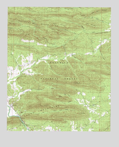
Caddo Gap, AR USGS Topographic Map
Click on map above to begin viewing in our Map Viewer.

This topographic map contains these locations and features:
Feature Name Type Latitude Longitude GNIS ID View Map
Bassinger CemeteryCemeteryN34.3820°W93.6071°63446View Map
Bear MountainSummitN34.4834°W93.6230°70572View Map
Bear Water HollowValleyN34.4023°W93.5374°70580View Map
Bethel CemeteryCemeteryN34.4104°W93.6188°70636View Map
Black CemeteryCemeteryN34.3787°W93.6116°63453View Map
Buttermilk SpringsSpringN34.4308°W93.6094°70942View Map
Caddo GapPopulated PlaceN34.4001°W93.6194°76486View Map
Caddo GapGapN34.3890°W93.6088°70950View Map
Caddo Gap Post OfficePost OfficeN34.4013°W93.6194°84245View Map
Caddo Gap School (historical)SchoolN34.4004°W93.6202°63462View Map
Caddo Gap Volunteer Fire DepartmentBuildingN34.3838°W93.6021°2116212View Map
Chapel School (historical)SchoolN34.4407°W93.6119°63468View Map
Collier SpringSpringN34.4839°W93.5928°71200View Map
Collier Spring Recreation SiteParkN34.4845°W93.5935°74443View Map
Crystal Mountain Scenic AreaParkN34.4943°W93.5849°74442View Map
Crystal MountainsRangeN34.4832°W93.5869°66991View Map
Crystal MountainsRidgeN34.4832°W93.5869°71303View Map
Family CemeteryCemeteryN34.3940°W93.6057°71589View Map
Fork MountainSummitN34.4834°W93.5291°71659View Map
Gap CreekStreamN34.3897°W93.6101°71718View Map
Gap Creek Natural AreaReserveN34.3943°W93.5884°2749534View Map
Gap School (historical)SchoolN34.3837°W93.6038°63495View Map
High PeakSummitN34.4729°W93.6044°72003View Map
Jones CemeteryCemeteryN34.4468°W93.5877°63517View Map
Jones ValleyValleyN34.3901°W93.6094°72218View Map
Jones Valley CemeteryCemeteryN34.3934°W93.6063°63519View Map
Liberty Baptist ChurchChurchN34.4409°W93.6113°77486View Map
Liberty CemeteryCemeteryN34.4412°W93.6113°63524View Map
Liberty School (historical)SchoolN34.4457°W93.6127°75274View Map
Locust MountainSummitN34.4768°W93.5663°72436View Map
Logan GapGapN34.4920°W93.5360°72444View Map
Logan Gap MountainSummitN34.4962°W93.5138°72445View Map
Mazarn MountainSummitN34.4829°W93.5682°77623View Map
Mount Zion CemeteryCemeteryN34.4515°W93.5468°63556View Map
Mount Zion School (historical)SchoolN34.4529°W93.5419°63557View Map
Mountain Home CemeteryCemeteryN34.4018°W93.5218°72789View Map
Mountain Home School (historical)SchoolN34.4018°W93.5205°63558View Map
Nelson CemeteryCemeteryN34.3854°W93.5193°72844View Map
Nelson MountainSummitN34.3932°W93.5382°72847View Map
Nicholson CemeteryCemeteryN34.3818°W93.5280°77851View Map
Nicholson School (historical)SchoolN34.3809°W93.5280°63566View Map
Old Bethel School (historical)SchoolN34.4198°W93.6177°63581View Map
OphirPopulated PlaceN34.4404°W93.6113°64913View Map
PlataPopulated PlaceN34.4526°W93.5469°73118View Map
Pole Branch HollowValleyN34.4587°W93.5138°73149View Map
Rattlesnake CreekStreamN34.4482°W93.5574°64914View Map
Rattlesnake CreekStreamN34.4470°W93.5791°78136View Map
Rough CreekStreamN34.4515°W93.5469°73389View Map
Saint Pauls ChurchChurchN34.3812°W93.6002°73459View Map
Sharp Top MountainSummitN34.4240°W93.5430°78336View Map
Shockey Chapel (historical)ChurchN34.4401°W93.6196°63622View Map
Smith CreekStreamN34.4332°W93.6088°73616View Map
Smith MountainRidgeN34.4604°W93.6166°73621View Map
Strawn MountainSummitN34.4012°W93.5752°73738View Map
Strawn SpringsSpringN34.3973°W93.6071°64915View Map
Sylvan Lake (historical)ReservoirN34.3940°W93.6021°63634View Map
Township of Caddo GapCivilN34.4010°W93.5888°1954007View Map
Township of NormanCivilN34.4678°W93.6112°1954012View Map
Township of Walnut (historical)CivilN34.3918°W93.5544°68895View Map
Wheeler MountainSummitN34.4926°W93.6232°74094View Map
White MountainSummitN34.4087°W93.5630°74113View Map
Wilson CreekStreamN34.4615°W93.5563°74172View Map

Note: Coordinates in the location and feature list above are referenced to NAD83 datum.


Copyright (C) 2008-2024 Ryan Niemi / Sunset Dynamics ... All Rights Reserved