TopoQuest Logo
Do you find TopoQuest useful?
Help keep TopoQuest running and adding new maps/features by donating!
Bitcoin:  19c7KJd3qBynnjoSw5npx9KScwjBe4ifkT
Litecoin:  LXs6TkuXGGXo1vDsWCkWVdjQX94eUKd6ui
Home View Maps Find Maps Find Places Resources & Links


McLoud, Oklahoma Topographic Map

USGS Map Title: McLoud, OK
USGS Map MRC: 35097D1
DRG (GeoTIFF) Download: o35097d1.tif


Neighboring USGS Topographic Map Quads:


  Horseshoe Lake, OK  
35097E2
 

  Luther SE, OK  
35097E1
 

  Meeker, OK  
35096E8
 

  Harrah, OK  
35097D2
 

  McLoud, OK  
35097D1
 

  Aydelotte, OK  
35096D8
 

  Stella, OK  
35097C2
 

  Shawnee Reservoir, OK  
35097C1
 

  Shawnee, OK  
35096C8


Map MRC Location:

N36°
W98°
N36°
W97°
H8 H7 H6 H5 H4 H3 H2 H1
G8 G7 G6 G5 G4 G3 G2 G1
F8 F7 F6 F5 F4 F3 F2 F1
E8 E7 E6 E5 E4 E3 E2 E1
D8 D7 D6 D5 D4 D3 D2 D1
C8 C7 C6 C5 C4 C3 C2 C1
B8 B7 B6 B5 B4 B3 B2 B1
A8 A7 A6 A5 A4 A3 A2 A1
N35°
W98°
N35°
W97°

McLoud, OK USGS 1:24K Topographic Map Preview:
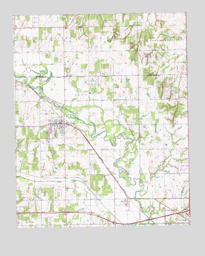
McLoud, OK USGS Topographic Map
Click on map above to begin viewing in our Map Viewer.

This topographic map contains these locations and features:
Feature Name Type Latitude Longitude GNIS ID View Map
Abrams CemeteryCemeteryN35.4342°W97.0272°1089514View Map
Assembly of God ChurchChurchN35.3978°W97.0892°1089735View Map
Bullard SpringSpringN35.4840°W97.0547°1090685View Map
Centerville CemeteryCemeteryN35.4008°W97.0001°1091157View Map
Chager SpringSpringN35.4856°W97.0520°1091192View Map
Church of ChristChurchN35.4334°W97.0972°1798731View Map
Church of Christ LakeviewChurchN35.3909°W97.0897°1809967View Map
City of McLoudCivilN35.4070°W97.1014°2412969View Map
Clarks HeightsPopulated PlaceN35.3765°W97.0009°1091392View Map
DalePopulated PlaceN35.3901°W97.0450°1091919View Map
Dale CemeteryCemeteryN35.3773°W97.0622°1091920View Map
Dale Census Designated PlaceCensusN35.3842°W97.0435°2629915View Map
Dale Elementary SchoolSchoolN35.3880°W97.0465°2712946View Map
Dale High SchoolSchoolN35.3880°W97.0465°2712861View Map
Dale Junior High SchoolSchoolN35.3880°W97.0465°1790312View Map
Doddehl SpringSpringN35.4923°W97.0753°1092113View Map
First United Methodist ChurchChurchN35.4328°W97.0972°1798732View Map
Flying N Ranch Airport (historical)AirportN35.4981°W97.0211°1102562View Map
Hazel DellPopulated PlaceN35.4490°W97.0003°1100484View Map
Jent CemeteryCemeteryN35.4567°W97.0531°1094214View Map
Kickapoo CemeteryCemeteryN35.4639°W97.0867°2704479View Map
Kickapoo MissionChurchN35.4640°W97.0864°1094367View Map
Kickapoo Tribal PoliceBuildingN35.4886°W97.0893°2757941View Map
Kishketon LakeLakeN35.4620°W97.1002°1094412View Map
L D Airport (historical)AirportN35.4584°W97.0672°1102545View Map
McLoudPopulated PlaceN35.4359°W97.0914°1095268View Map
McLoud CemeteryCemeteryN35.4431°W97.1247°1095269View Map
McLoud Elementary SchoolSchoolN35.4341°W97.0929°1793762View Map
McLoud Fire DepartmentBuildingN35.4334°W97.0890°2657410View Map
McLoud Gas FieldOilfieldN35.4528°W97.0761°1095270View Map
McLoud High SchoolSchoolN35.4258°W97.0991°1790400View Map
McLoud Junior High SchoolSchoolN35.4270°W97.1009°1790401View Map
McLoud Police DepartmentBuildingN35.4357°W97.0923°2757415View Map
MidwayPopulated PlaceN35.4926°W97.0886°1095373View Map
Minneha CemeteryCemeteryN35.3969°W97.1064°2708669View Map
Minneha ChurchChurchN35.3965°W97.1067°1095436View Map
Saint Johns Lutheran CemeteryCemeteryN35.4273°W97.1074°2356469View Map
Saint Vincent De Paul ChurchChurchN35.4351°W97.0986°1798733View Map
Southwest Lincoln County Fire Protection District 1 Station 3BuildingN35.4996°W97.1061°2657124View Map
Township of BalesCivilN35.4112°W97.0628°1824929View Map
Wagon Wheel SchoolSchoolN35.4045°W97.0622°1099287View Map

Note: Coordinates in the location and feature list above are referenced to NAD83 datum.


Copyright (C) 2008-2025 Ryan Niemi / Sunset Dynamics ... All Rights Reserved