TopoQuest Logo
Do you find TopoQuest useful?
Help keep TopoQuest running and adding new maps/features by donating!
Bitcoin:  19c7KJd3qBynnjoSw5npx9KScwjBe4ifkT
Litecoin:  LXs6TkuXGGXo1vDsWCkWVdjQX94eUKd6ui
Home View Maps Find Maps Find Places Resources & Links


Harrah, Oklahoma Topographic Map

USGS Map Title: Harrah, OK
USGS Map MRC: 35097D2
DRG (GeoTIFF) Download: o35097d2.tif


Neighboring USGS Topographic Map Quads:


  Jones, OK  
35097E3
 

  Horseshoe Lake, OK  
35097E2
 

  Luther SE, OK  
35097E1
 

  Choctaw, OK  
35097D3
 

  Harrah, OK  
35097D2
 

  McLoud, OK  
35097D1
 

  Franklin, OK  
35097C3
 

  Stella, OK  
35097C2
 

  Shawnee Reservoir, OK  
35097C1


Map MRC Location:

N36°
W98°
N36°
W97°
H8 H7 H6 H5 H4 H3 H2 H1
G8 G7 G6 G5 G4 G3 G2 G1
F8 F7 F6 F5 F4 F3 F2 F1
E8 E7 E6 E5 E4 E3 E2 E1
D8 D7 D6 D5 D4 D3 D2 D1
C8 C7 C6 C5 C4 C3 C2 C1
B8 B7 B6 B5 B4 B3 B2 B1
A8 A7 A6 A5 A4 A3 A2 A1
N35°
W98°
N35°
W97°

Harrah, OK USGS 1:24K Topographic Map Preview:
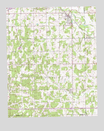
Harrah, OK USGS Topographic Map
Click on map above to begin viewing in our Map Viewer.

This topographic map contains these locations and features:
Feature Name Type Latitude Longitude GNIS ID View Map
Assembly of God ChurchChurchN35.4812°W97.1825°1798295View Map
Choctaw Fire Department Station 3BuildingN35.4412°W97.2476°2658669View Map
Choctaw Pentecostal Holiness ChurchChurchN35.4578°W97.2473°1782689View Map
Christ Lutheran ChurchChurchN35.4703°W97.1600°1798296View Map
Church of Christ-HarrahChurchN35.4931°W97.2056°1798297View Map
City of HarrahCivilN35.4798°W97.1864°2410705View Map
Clara Reynolds Elementary SchoolSchoolN35.4738°W97.1692°1793695View Map
First Baptist ChurchChurchN35.4898°W97.1664°1798298View Map
First Baptist Church-HarrahChurchN35.4912°W97.1661°1798299View Map
HarrahPopulated PlaceN35.4895°W97.1636°1093561View Map
Harrah Fire Department Station 1BuildingN35.4873°W97.1632°2658286View Map
Harrah Freewill Baptist ChurchChurchN35.4640°W97.1781°1798300View Map
Harrah High SchoolSchoolN35.4869°W97.1704°1793692View Map
Harrah Middle SchoolSchoolN35.4891°W97.1654°1793693View Map
Harrah Middle SchoolSchoolN35.4826°W97.1758°2712980View Map
Harrah Police DepartmentBuildingN35.4778°W97.1603°2757734View Map
Harrah Volunteer Fire Department Station 2BuildingN35.4927°W97.2043°2658670View Map
Indian Meridian Elementary SchoolSchoolN35.4467°W97.2485°1803906View Map
Jager CemeteryCemeteryN35.4717°W97.1960°2677969View Map
James Griffith Intermediate SchoolSchoolN35.4482°W97.2484°1803907View Map
Kansas School CemeteryCemeteryN35.4500°W97.2150°2677973View Map
Lower Forty Airport (historical)AirportN35.4608°W97.1977°1102493View Map
Memory Lane CemeteryCemeteryN35.4792°W97.1694°2677967View Map
Nazarene Parsonage ChurchChurchN35.4806°W97.1614°1798301View Map
NewallaPopulated PlaceN35.4051°W97.1628°1095849View Map
Newalla Fire DepartmentBuildingN35.4109°W97.1593°2658269View Map
Oknoname 1 DamDamN35.4501°W97.2170°1752365View Map
Oknoname 1 ReservoirReservoirN35.4501°W97.2170°1752366View Map
Oknoname 2 DamDamN35.4817°W97.2070°1752363View Map
Oknoname 2 ReservoirReservoirN35.4817°W97.2070°1752364View Map
Oknoname 6 DamDamN35.4551°W97.2320°1752353View Map
Oknoname 6 ReservoirReservoirN35.4551°W97.2320°1752354View Map
Russell Babb Elementary SchoolSchoolN35.4791°W97.1616°1793694View Map
Saint Teresa's Catholic CemeteryCemeteryN35.4853°W97.1608°2677981View Map
Saint Teresas Catholic ChurchChurchN35.4842°W97.1636°1798302View Map
Steciak StripAirportN35.4920°W97.1839°1102492View Map
Texas ChurchChurchN35.4348°W97.2128°1098824View Map
Township of PottawatomieCivilN35.4195°W97.1920°1824764View Map
Trinity Chapel Pentecostal ChurchChurchN35.4342°W97.1598°1798303View Map
Virginia Smith Elementary SchoolSchoolN35.4793°W97.1731°1793696View Map
World Bible ChurchLocaleN35.4498°W97.2406°1100015View Map

Note: Coordinates in the location and feature list above are referenced to NAD83 datum.


Copyright (C) 2008-2025 Ryan Niemi / Sunset Dynamics ... All Rights Reserved