TopoQuest Logo
Do you find TopoQuest useful?
Help keep TopoQuest running and adding new maps/features by donating!
Bitcoin:  19c7KJd3qBynnjoSw5npx9KScwjBe4ifkT
Litecoin:  LXs6TkuXGGXo1vDsWCkWVdjQX94eUKd6ui
Home View Maps Find Maps Find Places Resources & Links


McLouth, Kansas Topographic Map

USGS Map Title: McLouth, KS
USGS Map MRC: 39095B2
DRG (GeoTIFF) Download: o39095b2.tif


Neighboring USGS Topographic Map Quads:


  Winchester, KS  
39095C3
 

  Easton SW, KS  
39095C2
 

  Easton, KS  
39095C1
 

  Oskaloosa, KS  
39095B3
 

  McLouth, KS  
39095B2
 

  Jarbalo, KS  
39095B1
 

  Williamstown, KS  
39095A3
 

  Midland, KS  
39095A2
 

  Tonganoxie, KS  
39095A1


Map MRC Location:

N40°
W96°
N40°
W95°
H8 H7 H6 H5 H4 H3 H2 H1
G8 G7 G6 G5 G4 G3 G2 G1
F8 F7 F6 F5 F4 F3 F2 F1
E8 E7 E6 E5 E4 E3 E2 E1
D8 D7 D6 D5 D4 D3 D2 D1
C8 C7 C6 C5 C4 C3 C2 C1
B8 B7 B6 B5 B4 B3 B2 B1
A8 A7 A6 A5 A4 A3 A2 A1
N39°
W96°
N39°
W95°

McLouth, KS USGS 1:24K Topographic Map Preview:
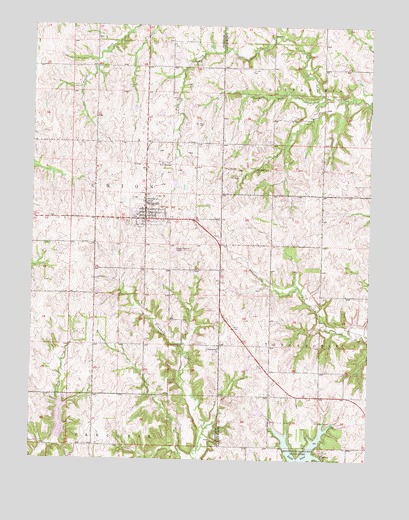
McLouth, KS USGS Topographic Map
Click on map above to begin viewing in our Map Viewer.

This topographic map contains these locations and features:
Feature Name Type Latitude Longitude GNIS ID View Map
Brown Grove SchoolSchoolN39.2375°W95.2086°478525View Map
Brown SchoolLocaleN39.2228°W95.1547°478526View Map
City of McLouthCivilN39.1959°W95.2084°2395075View Map
D'Field AirportAirportN39.2248°W95.1927°2675732View Map
Dorei Airport (historical)AirportN39.1917°W95.1725°481349View Map
Eagle Springs (historical)LocaleN39.1311°W95.1772°482140View Map
Fowler CemeteryCemeteryN39.2382°W95.1915°478528View Map
Jefferson County Fire Department District 9BuildingN39.1963°W95.2093°2111599View Map
Lake DabanawaReservoirN39.1361°W95.2391°480401View Map
Leavenworth County State ParkParkN39.1272°W95.1502°478530View Map
McLouthPopulated PlaceN39.1958°W95.2083°478524View Map
McLouth CemeteryCemeteryN39.1933°W95.2150°2673292View Map
McLouth Elementary SchoolSchoolN39.1952°W95.2115°480358View Map
McLouth Fire DepartmentBuildingN39.1984°W95.2081°2111943View Map
McLouth High SchoolSchoolN39.1964°W95.2119°480359View Map
McLouth Medical ClinicHospitalN39.1958°W95.2086°2511072View Map
McLouth Middle SchoolSchoolN39.1957°W95.2116°2506537View Map
McLouth Police DepartmentBuildingN39.1984°W95.2082°2503926View Map
McLouth Post OfficePost OfficeN39.1959°W95.2086°2510929View Map
McLouth Public LibraryBuildingN39.1963°W95.2086°2509980View Map
McLouth Sewer Treatment PlantLocaleN39.1845°W95.1973°2511243View Map
McLouth Unified School District OfficesSchoolN39.1959°W95.2120°2506429View Map
Midway (historical)LocaleN39.2169°W95.2266°481946View Map
South Fork Fall CreekStreamN39.2303°W95.1430°478527View Map
Stanwood (historical)LocaleN39.1444°W95.1605°482311View Map
Stanwood Friends ChurchChurchN39.1575°W95.1806°478521View Map
Stanwood SchoolSchoolN39.1469°W95.1625°478522View Map
Threshing Bee AirportAirportN39.1917°W95.2155°481350View Map
Township of TonganoxieCivilN39.1370°W95.1275°478532View Map
Township of UnionCivilN39.2140°W95.2200°478347View Map
Wild Horse SchoolSchoolN39.1797°W95.2016°478523View Map
Wildhorse CemeteryCemeteryN39.1801°W95.1969°2673287View Map
Woodstock (historical)LocaleN39.1350°W95.2266°482262View Map
Woodstock SchoolSchoolN39.1439°W95.2191°478520View Map

Note: Coordinates in the location and feature list above are referenced to NAD83 datum.


Copyright (C) 2008-2025 Ryan Niemi / Sunset Dynamics ... All Rights Reserved