TopoQuest Logo
Do you find TopoQuest useful?
Help keep TopoQuest running and adding new maps/features by donating!
Bitcoin:  19c7KJd3qBynnjoSw5npx9KScwjBe4ifkT
Litecoin:  LXs6TkuXGGXo1vDsWCkWVdjQX94eUKd6ui
Home View Maps Find Maps Find Places Resources & Links


Oskaloosa, Kansas Topographic Map

USGS Map Title: Oskaloosa, KS
USGS Map MRC: 39095B3
DRG (GeoTIFF) Download: o39095b3.tif


Neighboring USGS Topographic Map Quads:


  Valley Falls, KS  
39095C4
 

  Winchester, KS  
39095C3
 

  Easton SW, KS  
39095C2
 

  Ozawkie, KS  
39095B4
 

  Oskaloosa, KS  
39095B3
 

  McLouth, KS  
39095B2
 

  Perry, KS  
39095A4
 

  Williamstown, KS  
39095A3
 

  Midland, KS  
39095A2


Map MRC Location:

N40°
W96°
N40°
W95°
H8 H7 H6 H5 H4 H3 H2 H1
G8 G7 G6 G5 G4 G3 G2 G1
F8 F7 F6 F5 F4 F3 F2 F1
E8 E7 E6 E5 E4 E3 E2 E1
D8 D7 D6 D5 D4 D3 D2 D1
C8 C7 C6 C5 C4 C3 C2 C1
B8 B7 B6 B5 B4 B3 B2 B1
A8 A7 A6 A5 A4 A3 A2 A1
N39°
W96°
N39°
W95°

Oskaloosa, KS USGS 1:24K Topographic Map Preview:
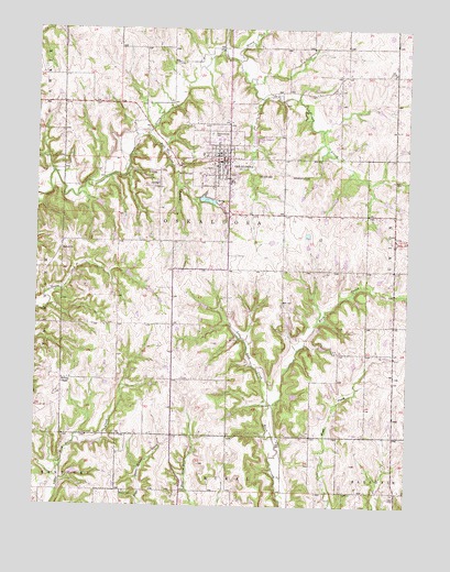
Oskaloosa, KS USGS Topographic Map
Click on map above to begin viewing in our Map Viewer.

This topographic map contains these locations and features:
Feature Name Type Latitude Longitude GNIS ID View Map
Bethel ChurchChurchN39.1919°W95.3669°478509View Map
Buck Point SchoolLocaleN39.2306°W95.3669°478513View Map
Burr Oak BranchStreamN39.2219°W95.3386°478517View Map
Buster CemeteryCemeteryN39.1286°W95.3447°478498View Map
C A J Dairy FarmsLocaleN39.2003°W95.2667°2726235View Map
Central ChapelChurchN39.2381°W95.2544°478515View Map
City of OskaloosaCivilN39.2161°W95.3140°2396095View Map
Dick SchoolSchoolN39.1431°W95.3578°478499View Map
Hickory Pointe Care and Rehabilitation CenterBuildingN39.2140°W95.3124°2510127View Map
Hinton SchoolLocaleN39.2167°W95.2544°478512View Map
Honey CreekStreamN39.2414°W95.3077°478348View Map
Jefferson County Ambulance ServiceBuildingN39.2077°W95.3115°2696573View Map
Jefferson County CourthouseBuildingN39.2160°W95.3137°2625069View Map
Jefferson County Health DepartmentBuildingN39.2070°W95.3116°2510456View Map
Jefferson County JailBuildingN39.2070°W95.3115°2504376View Map
Jefferson County Sheriff's OfficeBuildingN39.2070°W95.3117°2503999View Map
Kingdom Hall of Jehovahs WitnessesChurchN39.2122°W95.3102°2509840View Map
Leaverton SchoolLocaleN39.2311°W95.2727°478514View Map
Little Buck CreekStreamN39.1517°W95.2961°478504View Map
Living Water Evangelical Free ChurchChurchN39.2185°W95.3295°2510486View Map
McIntosh (historical)LocaleN39.1958°W95.2919°481935View Map
Midway ChapelChurchN39.1581°W95.3664°478500View Map
Natural Resources Conservation Service Oskaloosa Service CenterBuildingN39.2155°W95.3178°2504235View Map
OskaloosaPopulated PlaceN39.2153°W95.3127°478510View Map
Oskaloosa Church of ChristChurchN39.2174°W95.3120°2509675View Map
Oskaloosa Church of ChristChurchN39.2174°W95.3120°2509427View Map
Oskaloosa City HallBuildingN39.2152°W95.3132°2510067View Map
Oskaloosa Elementary SchoolSchoolN39.2212°W95.3130°480357View Map
Oskaloosa Fire District 8BuildingN39.2157°W95.3170°2111702View Map
Oskaloosa First Baptist ChurchChurchN39.2189°W95.3110°2509924View Map
Oskaloosa First Presbyterian ChurchChurchN39.2152°W95.3165°2510313View Map
Oskaloosa First United Methodist ChurchChurchN39.2174°W95.3147°2509678View Map
Oskaloosa Junior - Senior High SchoolSchoolN39.2213°W95.3144°480356View Map
Oskaloosa Middle SchoolSchoolN39.2211°W95.3138°2506587View Map
Oskaloosa Police DepartmentBuildingN39.2168°W95.3104°2504010View Map
Oskaloosa Post OfficePost OfficeN39.2163°W95.3126°2510934View Map
Oskaloosa Public LibraryBuildingN39.2152°W95.3133°2511075View Map
Oskaloosa Public Schools District OfficeSchoolN39.2214°W95.3149°2506453View Map
Oskaloosa Water Treatment PlantLocaleN39.2219°W95.3024°2510937View Map
Parsons SchoolSchoolN39.1867°W95.2550°478508View Map
Pleasant View CemeteryCemeteryN39.2228°W95.3166°478511View Map
Shomin Airport (historical)AirportN39.2167°W95.3372°481327View Map
Shomin Industrial ParkLocaleN39.2120°W95.3319°2509586View Map
Township of OskaloosaCivilN39.2177°W95.3128°478346View Map
Wellman School (historical)SchoolN39.1286°W95.2519°478507View Map

Note: Coordinates in the location and feature list above are referenced to NAD83 datum.


Copyright (C) 2008-2025 Ryan Niemi / Sunset Dynamics ... All Rights Reserved