TopoQuest Logo
Do you find TopoQuest useful?
Help keep TopoQuest running and adding new maps/features by donating!
Bitcoin:  19c7KJd3qBynnjoSw5npx9KScwjBe4ifkT
Litecoin:  LXs6TkuXGGXo1vDsWCkWVdjQX94eUKd6ui
Home View Maps Find Maps Find Places Resources & Links


McMillan, Michigan Topographic Map

USGS Map Title: McMillan, MI
USGS Map MRC: 46085C6
DRG (GeoTIFF) Download: o46085c6.tif


Neighboring USGS Topographic Map Quads:


  Tahquamenon Lakes, MI  
46085D7
 

  Buckeye Lake, MI  
46085D6
 

  Auger Lake, MI  
46085D5
 

  Hardwood Island, MI  
46085C7
 

  McMillan, MI  
46085C6
 

  Newberry, MI  
46085C5
 

  Curtis West, MI  
46085B7
 

  Curtis East, MI  
46085B6
 

  Millecoquins, MI  
46085B5


Map MRC Location:

N47°
W86°
N47°
W85°
H8 H7 H6 H5 H4 H3 H2 H1
G8 G7 G6 G5 G4 G3 G2 G1
F8 F7 F6 F5 F4 F3 F2 F1
E8 E7 E6 E5 E4 E3 E2 E1
D8 D7 D6 D5 D4 D3 D2 D1
C8 C7 C6 C5 C4 C3 C2 C1
B8 B7 B6 B5 B4 B3 B2 B1
A8 A7 A6 A5 A4 A3 A2 A1
N46°
W86°
N46°
W85°

McMillan, MI USGS 1:24K Topographic Map Preview:
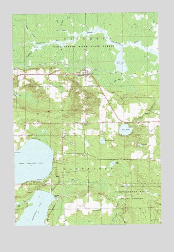
McMillan, MI USGS Topographic Map
Click on map above to begin viewing in our Map Viewer.

This topographic map contains these locations and features:
Feature Name Type Latitude Longitude GNIS ID View Map
Big Lake CampgroundLocaleN46.2569°W85.7214°2360471View Map
Columbus Township CemeteryCemeteryN46.3325°W85.6872°2360474View Map
Columbus Township ParkParkN46.3386°W85.6897°2360463View Map
Columbus Township Volunteer Fire DepartmentBuildingN46.3299°W85.6766°2626800View Map
East CreekStreamN46.3644°W85.7029°625170View Map
East LakeLakeN46.3058°W85.6549°625212View Map
East Lakefield CemeteryCemeteryN46.2916°W85.6901°625217View Map
Fork CreekStreamN46.2644°W85.7354°626290View Map
HelmerPopulated PlaceN46.2664°W85.7157°628066View Map
Helmer CreekStreamN46.2689°W85.7190°1620166View Map
Helmer House Inn Historical MarkerParkN46.2711°W85.7192°2360472View Map
Helmer Post Office (historical)Post OfficeN46.2664°W85.7156°2360456View Map
Lakefield ChurchChurchN46.2744°W85.7237°630011View Map
LaketonPopulated PlaceN46.3428°W85.7485°1617670View Map
Laketon Post Office (historical)Post OfficeN46.3428°W85.7483°2360455View Map
Laketon SloughStreamN46.3572°W85.7221°630043View Map
Laketon Station (historical)LocaleN46.3428°W85.7486°2360454View Map
Locke CreekStreamN46.2753°W85.7126°630851View Map
Locke LakeLakeN46.2862°W85.6659°630852View Map
Lost LakeLakeN46.2967°W85.6427°631104View Map
MarksPopulated PlaceN46.2597°W85.6976°1617702View Map
McCormick LakeLakeN46.2993°W85.6748°631846View Map
McMillanPopulated PlaceN46.3389°W85.6873°631994View Map
McMillan CornerPopulated PlaceN46.3103°W85.6890°1617713View Map
McMillan Post OfficePost OfficeN46.3388°W85.6894°2360467View Map
McMillan StationLocaleN46.3425°W85.6875°2360466View Map
McMillan United Methodist ChurchChurchN46.3378°W85.6872°2360470View Map
Mud LakeLakeN46.3456°W85.6578°633042View Map
Mud Lake CreekStreamN46.3411°W85.6562°633074View Map
North Manistique LakeLakeN46.2873°W85.7371°633607View Map
Northstar Baptist ChurchChurchN46.3317°W85.6872°2360468View Map
Northstar Christian AcademySchoolN46.3317°W85.6872°2360469View Map
Old East Lakefield CemeteryCemeteryN46.2589°W85.6771°625216View Map
Red CreekStreamN46.3628°W85.6948°635708View Map
Seventh-Day Adventist ChurchChurchN46.3200°W85.7472°2360464View Map
Silver CreekStreamN46.3633°W85.6326°637923View Map
Syphon CreekStreamN46.3583°W85.7310°1614524View Map
T LakeLakeN46.2727°W85.6552°1614527View Map
Teaspoon CreekStreamN46.3472°W85.6251°1614648View Map
Township of LakefieldCivilN46.2884°W85.7394°1626582View Map

Note: Coordinates in the location and feature list above are referenced to NAD83 datum.


Copyright (C) 2008-2024 Ryan Niemi / Sunset Dynamics ... All Rights Reserved