TopoQuest Logo
Do you find TopoQuest useful?
Help keep TopoQuest running and adding new maps/features by donating!
Bitcoin:  19c7KJd3qBynnjoSw5npx9KScwjBe4ifkT
Litecoin:  LXs6TkuXGGXo1vDsWCkWVdjQX94eUKd6ui
Home View Maps Find Maps Find Places Resources & Links


Columbus, Illinois Topographic Map

USGS Map Title: Columbus, IL
USGS Map MRC: 39091H2
DRG (GeoTIFF) Download: o39091h2.tif


Neighboring USGS Topographic Map Quads:


  Mendon, IL  
40091A3
 

  Coatsburg, IL  
40091A2
 

  Camp Point, IL  
40091A1
 

  Quincy East, IL  
39091H3
 

  Columbus, IL  
39091H2
 

  Liberty, IL  
39091H1
 

  Marblehead, IL  
39091G3
 

  Payson, IL  
39091G2
 

  Richfield, IL  
39091G1


Map MRC Location:

N40°
W92°
N40°
W91°
H8 H7 H6 H5 H4 H3 H2 H1
G8 G7 G6 G5 G4 G3 G2 G1
F8 F7 F6 F5 F4 F3 F2 F1
E8 E7 E6 E5 E4 E3 E2 E1
D8 D7 D6 D5 D4 D3 D2 D1
C8 C7 C6 C5 C4 C3 C2 C1
B8 B7 B6 B5 B4 B3 B2 B1
A8 A7 A6 A5 A4 A3 A2 A1
N39°
W92°
N39°
W91°

Columbus, IL USGS 1:24K Topographic Map Preview:
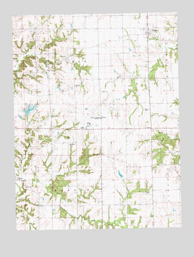
Columbus, IL USGS Topographic Map
Click on map above to begin viewing in our Map Viewer.

This topographic map contains these locations and features:
Feature Name Type Latitude Longitude GNIS ID View Map
Adams CountyCivilN39.9879°W91.1885°424202View Map
BurtonPopulated PlaceN39.9048°W91.2490°405275View Map
Burton Cave Nature PreserveParkN39.8850°W91.2485°2009653View Map
Burton CemeteryCemeteryN39.8998°W91.2432°1720502View Map
Burton TownhallBuildingN39.8889°W91.2024°1720503View Map
ColumbusPopulated PlaceN39.9881°W91.1468°406414View Map
Columbus CemeteryCemeteryN39.9850°W91.1407°1984941View Map
Douglas School (historical)SchoolN39.8931°W91.1854°407349View Map
Franklin School (historical)SchoolN39.8970°W91.1254°408685View Map
Gilmer TownhallBuildingN39.9800°W91.2046°1720523View Map
Independence CemeteryCemeteryN39.9250°W91.2082°1720536View Map
Independent School (historical)SchoolN39.9259°W91.2176°410824View Map
Kimmons CemeteryCemeteryN39.8964°W91.1496°1720538View Map
Lakeshore Hills LakeReservoirN39.9584°W91.2401°1691551View Map
Lakeshore Hills Lake DamDamN39.9584°W91.2401°1691550View Map
Lierly CemeteryCemeteryN39.9300°W91.1412°1720542View Map
Livingston School (historical)SchoolN39.9156°W91.1710°412455View Map
Maple Grove School (historical)SchoolN39.9870°W91.1657°412941View Map
Mount Pleasant CemeteryCemeteryN39.9584°W91.2037°1720552View Map
Mount Pleasant Church (historical)ChurchN39.9587°W91.2040°414059View Map
Mount Pleasant School (historical)SchoolN39.9531°W91.2321°414065View Map
Pleasant Grove ChurchChurchN39.9187°W91.1857°415794View Map
Prairie School (historical)SchoolN39.9484°W91.1838°416160View Map
Quincy Regional Airport-Baldwin FieldAirportN39.9379°W91.1939°427723View Map
Saint Joseph CemeteryCemeteryN39.9670°W91.2249°1984986View Map
Saint Joseph School (historical)SchoolN39.9675°W91.2240°417460View Map
Seigel School (historical)SchoolN39.8814°W91.1457°418188View Map
Tournear CreekStreamN39.9039°W91.2438°419788View Map
Township of BurtonCivilN39.8896°W91.2056°428741View Map
Township of GilmerCivilN39.9774°W91.2054°429053View Map
Village of ColumbusCivilN39.9881°W91.1452°2398605View Map
West Union School (historical)SchoolN39.9400°W91.1471°420938View Map

Note: Coordinates in the location and feature list above are referenced to NAD83 datum.


Copyright (C) 2008-2025 Ryan Niemi / Sunset Dynamics ... All Rights Reserved