TopoQuest Logo
Do you find TopoQuest useful?
Help keep TopoQuest running and adding new maps/features by donating!
Bitcoin:  19c7KJd3qBynnjoSw5npx9KScwjBe4ifkT
Litecoin:  LXs6TkuXGGXo1vDsWCkWVdjQX94eUKd6ui
Home View Maps Find Maps Find Places Resources & Links


Coatsburg, Illinois Topographic Map

USGS Map Title: Coatsburg, IL
USGS Map MRC: 40091A2
DRG (GeoTIFF) Download: o40091a2.tif


Neighboring USGS Topographic Map Quads:


  Tioga, IL  
40091B3
 

  Loraine, IL  
40091B2
 

  Bowen, IL  
40091B1
 

  Mendon, IL  
40091A3
 

  Coatsburg, IL  
40091A2
 

  Camp Point, IL  
40091A1
 

  Quincy East, IL  
39091H3
 

  Columbus, IL  
39091H2
 

  Liberty, IL  
39091H1


Map MRC Location:

N41°
W92°
N41°
W91°
H8 H7 H6 H5 H4 H3 H2 H1
G8 G7 G6 G5 G4 G3 G2 G1
F8 F7 F6 F5 F4 F3 F2 F1
E8 E7 E6 E5 E4 E3 E2 E1
D8 D7 D6 D5 D4 D3 D2 D1
C8 C7 C6 C5 C4 C3 C2 C1
B8 B7 B6 B5 B4 B3 B2 B1
A8 A7 A6 A5 A4 A3 A2 A1
N40°
W92°
N40°
W91°

Coatsburg, IL USGS 1:24K Topographic Map Preview:
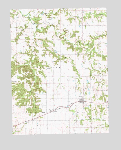
Coatsburg, IL USGS Topographic Map
Click on map above to begin viewing in our Map Viewer.

This topographic map contains these locations and features:
Feature Name Type Latitude Longitude GNIS ID View Map
Adams County Farm (historical)LocaleN40.0037°W91.1765°1983608View Map
Baldwin BranchStreamN40.1150°W91.2251°403855View Map
Bigneck CreekStreamN40.1189°W91.2246°406817View Map
Brushy CreekStreamN40.0987°W91.2188°405052View Map
Brushy School (historical)SchoolN40.0662°W91.1574°405065View Map
Byler CemeteryCemeteryN40.0648°W91.1987°404764View Map
Byler Cemetery Savanna Nature PreserveParkN40.0653°W91.1993°2009654View Map
Cate Family CemeteryCemeteryN40.0642°W91.1507°1720507View Map
Center School (historical)SchoolN40.0642°W91.1960°405814View Map
Central Adams County Fire Protection DistrictBuildingN40.0324°W91.1611°2640373View Map
CoatsburgPopulated PlaceN40.0328°W91.1576°406313View Map
Coffield School (historical)SchoolN40.1067°W91.1279°406330View Map
Elm CreekStreamN40.0875°W91.1496°407920View Map
Glenwood School (historical)SchoolN40.1045°W91.2360°409092View Map
Gooding CemeteryCemeteryN40.0364°W91.2143°1720525View Map
Gray Mound CemeteryCemeteryN40.0362°W91.1579°1720527View Map
Hog BranchStreamN40.0764°W91.2185°1785293View Map
Honey CreekStreamN40.1050°W91.2149°410472View Map
Johnson CemeteryCemeteryN40.0145°W91.1454°411156View Map
Laugh CemeteryCemeteryN40.0512°W91.2487°1984964View Map
Loraine QuarryMineN40.1212°W91.2049°1837327View Map
Lubbert FarmLocaleN40.0894°W91.2369°2568286View Map
Mealiff Landing Strip (historical)AirportN40.1106°W91.2029°1720549View Map
Morton School (historical)SchoolN40.0356°W91.2051°413870View Map
Mount Vernon School (historical)SchoolN40.1078°W91.1657°414100View Map
Oakwood School (historical)SchoolN40.0400°W91.2474°414942View Map
PalomaPopulated PlaceN40.0228°W91.1951°415325View Map
Paloma CemeteryCemeteryN40.0214°W91.2118°415326View Map
Paloma Post OfficePost OfficeN40.0217°W91.2024°1785318View Map
Paloma United Methodist ChurchChurchN40.0217°W91.1963°1983609View Map
Richland School (historical)SchoolN40.0062°W91.2049°416613View Map
Rocky Hill School (historical)SchoolN40.0870°W91.2432°416879View Map
Saint Peters Lutheran ChurchChurchN40.0309°W91.1610°1983611View Map
Township of Honey CreekCivilN40.0651°W91.2048°429143View Map
Village of CoatsburgCivilN40.0324°W91.1602°2398591View Map

Note: Coordinates in the location and feature list above are referenced to NAD83 datum.


Copyright (C) 2008-2024 Ryan Niemi / Sunset Dynamics ... All Rights Reserved