TopoQuest Logo
Do you find TopoQuest useful?
Help keep TopoQuest running and adding new maps/features by donating!
Bitcoin:  19c7KJd3qBynnjoSw5npx9KScwjBe4ifkT
Litecoin:  LXs6TkuXGGXo1vDsWCkWVdjQX94eUKd6ui
Home View Maps Find Maps Find Places Resources & Links


Mendon, Ohio Topographic Map

USGS Map Title: Mendon, OH
USGS Map MRC: 40084F5
DRG (GeoTIFF) Download: o40084f5.tif


Neighboring USGS Topographic Map Quads:


  Glenmore, OH  
40084G6
 

  Van Wert, OH  
40084G5
 

  Middle Point, OH  
40084G4
 

  Rockford, OH  
40084F6
 

  Mendon, OH  
40084F5
 

  Elgin, OH  
40084F4
 

  Erastus, OH  
40084E6
 

  Celina, OH  
40084E5
 

  Saint Marys, OH  
40084E4


Map MRC Location:

N41°
W85°
N41°
W84°
H8 H7 H6 H5 H4 H3 H2 H1
G8 G7 G6 G5 G4 G3 G2 G1
F8 F7 F6 F5 F4 F3 F2 F1
E8 E7 E6 E5 E4 E3 E2 E1
D8 D7 D6 D5 D4 D3 D2 D1
C8 C7 C6 C5 C4 C3 C2 C1
B8 B7 B6 B5 B4 B3 B2 B1
A8 A7 A6 A5 A4 A3 A2 A1
N40°
W85°
N40°
W84°

Mendon, OH USGS 1:24K Topographic Map Preview:
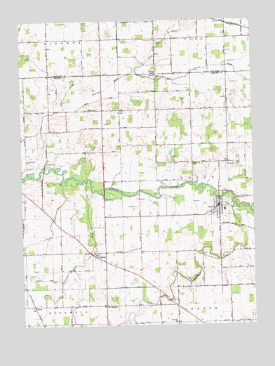
Mendon, OH USGS Topographic Map
Click on map above to begin viewing in our Map Viewer.

This topographic map contains these locations and features:
Feature Name Type Latitude Longitude GNIS ID View Map
A and A GreenhouseBuildingN40.7006°W84.5814°2651534View Map
Ayre DitchStreamN40.7134°W84.6069°1065902View Map
Bethel ChurchChurchN40.6912°W84.5330°1037940View Map
Bevington School (historical)SchoolN40.7423°W84.5519°1053721View Map
Blue Corner School (historical)SchoolN40.7203°W84.5522°1053590View Map
Boltzell School (historical)SchoolN40.7084°W84.6222°1053584View Map
Coil CemeteryCemeteryN40.6756°W84.5291°1039232View Map
Coil CemeteryCemeteryN40.6940°W84.5443°1039233View Map
Copp School (historical)SchoolN40.6262°W84.5905°1053582View Map
Dennison DitchStreamN40.6798°W84.5869°1065974View Map
Frisinger CemeteryCemeteryN40.7137°W84.5838°1040699View Map
Frisinger DitchStreamN40.7298°W84.5627°1040700View Map
Frisinger School (historical)SchoolN40.7153°W84.5905°1053585View Map
Fryer CemeteryCemeteryN40.6917°W84.5152°1040713View Map
Fryer School (historical)SchoolN40.6920°W84.5097°1053593View Map
Gross School (historical)SchoolN40.7125°W84.5172°1053594View Map
Hamilton CemeteryCemeteryN40.6539°W84.5283°1041263View Map
Kyle Prairie CreekStreamN40.7300°W84.5625°1042357View Map
Liberty Egg FarmLocaleN40.7408°W84.6156°2567632View Map
Liberty Egg FarmLocaleN40.7408°W84.6156°2629003View Map
MendonPopulated PlaceN40.6734°W84.5188°1085474View Map
Mendon - Union Fire DepartmentBuildingN40.6721°W84.5204°2550017View Map
Mendon CemeteryCemeteryN40.6906°W84.5138°1043222View Map
Mendon First Church of GodChurchN40.6734°W84.5200°1961398View Map
Mendon Police DepartmentBuildingN40.6732°W84.5189°2732785View Map
Mendon Post OfficePost OfficeN40.6737°W84.5194°2036683View Map
Mendon United Methodist ChurchChurchN40.6734°W84.5177°1961399View Map
Mendon-Union Elementary SchoolSchoolN40.6725°W84.5158°1054915View Map
Mendon-Union High SchoolSchoolN40.6720°W84.5158°1054916View Map
MercerPopulated PlaceN40.6550°W84.5855°1061509View Map
Mercer CemeteryCemeteryN40.6545°W84.5822°1961380View Map
Mercer Post Office (historical)Post OfficeN40.6556°W84.5861°2036673View Map
Mount Hope School (historical)SchoolN40.6259°W84.5130°1053591View Map
Mount Olive CemeteryCemeteryN40.7045°W84.6075°1043591View Map
Mount Tabor ChurchChurchN40.6331°W84.5800°1043632View Map
Palmer CemeteryCemeteryN40.6737°W84.5630°1044287View Map
Prairie School (historical)SchoolN40.6698°W84.6086°1053583View Map
Profit FarmLocaleN40.7361°W84.5628°2629004View Map
Protzman School (historical)SchoolN40.6914°W84.5522°1053589View Map
Red School (historical)SchoolN40.6514°W84.5186°1053592View Map
Roebuck CemeteryCemeteryN40.6353°W84.5449°1045151View Map
Roebuck CemeteryCemeteryN40.6920°W84.6113°1045152View Map
Roebuck School (historical)SchoolN40.6298°W84.5422°1053586View Map
School Number 1 (historical)SchoolN40.6550°W84.5516°1053587View Map
School Number 2 (historical)SchoolN40.6692°W84.5516°1053588View Map
Sherer CemeteryCemeteryN40.6768°W84.5094°1046190View Map
Shindeldecker CemeteryCemeteryN40.6926°W84.6219°1046220View Map
TamaPopulated PlaceN40.6331°W84.6188°1061672View Map
Tamah Post Office (historical)Post OfficeN40.6334°W84.6194°2037140View Map
Tomlinson CemeteryCemeteryN40.7275°W84.5511°1047088View Map
Town RunStreamN40.6884°W84.6177°1066239View Map
Township of UnionCivilN40.6845°W84.5136°1086632View Map
Twelvemile CreekStreamN40.6742°W84.5102°1058086View Map
Victor School (historical)SchoolN40.7037°W84.5330°1053595View Map
Village of MendonCivilN40.6733°W84.5176°2399312View Map
Wesley ChapelChurchN40.7278°W84.5522°1047696View Map
Yankee RunStreamN40.6850°W84.6025°1048177View Map

Note: Coordinates in the location and feature list above are referenced to NAD83 datum.


Copyright (C) 2008-2024 Ryan Niemi / Sunset Dynamics ... All Rights Reserved