TopoQuest Logo
Do you find TopoQuest useful?
Help keep TopoQuest running and adding new maps/features by donating!
Bitcoin:  19c7KJd3qBynnjoSw5npx9KScwjBe4ifkT
Litecoin:  LXs6TkuXGGXo1vDsWCkWVdjQX94eUKd6ui
Home View Maps Find Maps Find Places Resources & Links


Rockford, Ohio Topographic Map

USGS Map Title: Rockford, OH
USGS Map MRC: 40084F6
DRG (GeoTIFF) Download: o40084f6.tif


Neighboring USGS Topographic Map Quads:


  Wren, OH  
40084G7
 

  Glenmore, OH  
40084G6
 

  Van Wert, OH  
40084G5
 

  Willshire, OH  
40084F7
 

  Rockford, OH  
40084F6
 

  Mendon, OH  
40084F5
 

  New Corydon, IN  
40084E7
 

  Erastus, OH  
40084E6
 

  Celina, OH  
40084E5


Map MRC Location:

N41°
W85°
N41°
W84°
H8 H7 H6 H5 H4 H3 H2 H1
G8 G7 G6 G5 G4 G3 G2 G1
F8 F7 F6 F5 F4 F3 F2 F1
E8 E7 E6 E5 E4 E3 E2 E1
D8 D7 D6 D5 D4 D3 D2 D1
C8 C7 C6 C5 C4 C3 C2 C1
B8 B7 B6 B5 B4 B3 B2 B1
A8 A7 A6 A5 A4 A3 A2 A1
N40°
W85°
N40°
W84°

Rockford, OH USGS 1:24K Topographic Map Preview:
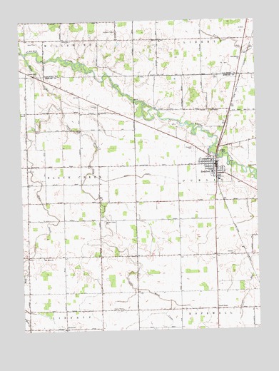
Rockford, OH USGS Topographic Map
Click on map above to begin viewing in our Map Viewer.

This topographic map contains these locations and features:
Feature Name Type Latitude Longitude GNIS ID View Map
Barks School (historical)SchoolN40.6912°W84.6672°1053578View Map
Black CreekStreamN40.7367°W84.7469°1065923View Map
Blackloon ReserveCivilN40.7198°W84.6688°1054881View Map
BursvillePopulated PlaceN40.6259°W84.7275°1038552View Map
Calvary United Brethren in Christ ChurchChurchN40.6898°W84.6505°1807442View Map
Central School (historical)SchoolN40.6945°W84.7466°1053574View Map
Charlies ReserveCivilN40.7062°W84.6894°1054889View Map
Coats CemeteryCemeteryN40.6900°W84.7466°1039211View Map
Crescent ReserveCivilN40.6984°W84.6669°1961393View Map
Deitsch School (historical)SchoolN40.6262°W84.7472°1053569View Map
East Bethel CemeteryCemeteryN40.6546°W84.7383°1961370View Map
East Bethel ChurchChurchN40.6548°W84.7389°1039966View Map
First United Methodist ChurchChurchN40.6914°W84.6477°1063349View Map
Fountain Chapel CemeteryCemeteryN40.6692°W84.7063°1040604View Map
Friends CemeteryCemeteryN40.6337°W84.6466°1961372View Map
Friends ChapelChurchN40.6334°W84.6469°1064688View Map
Godfreys ReserveCivilN40.7000°W84.6255°1054902View Map
Henderson School (historical)SchoolN40.7162°W84.6633°1053579View Map
Hopewell DairyLocaleN40.6350°W84.6864°2703623View Map
King School (historical)SchoolN40.7117°W84.7086°1053573View Map
Labadie ReserveCivilN40.7198°W84.7077°1054910View Map
Liberty CemeteryCemeteryN40.6337°W84.6966°1961376View Map
Liberty ChapelChurchN40.6334°W84.6975°1042510View Map
Little Black CreekStreamN40.7150°W84.7277°1042646View Map
Manley School (historical)SchoolN40.6842°W84.7091°1053572View Map
Mercer County Emergency Medical ServicesBuildingN40.6904°W84.6470°2550697View Map
Meyers Mobile Home ParkPopulated PlaceN40.6953°W84.6525°2651948View Map
Mount Zion ChurchChurchN40.7423°W84.6766°1043665View Map
Olive Branch ChurchChurchN40.7342°W84.6333°1044157View Map
Otterbein CemeteryCemeteryN40.6556°W84.6380°1961382View Map
Otterbin ChurchChurchN40.6553°W84.6388°1065221View Map
Parkway High SchoolSchoolN40.6884°W84.6488°1054925View Map
Pleasant Grove CemeteryCemeteryN40.7284°W84.7419°1807432View Map
Red School (historical)SchoolN40.6545°W84.6663°1053577View Map
Ridge CemeteryCemeteryN40.7425°W84.6758°1807434View Map
Ridge School (historical)SchoolN40.7420°W84.6686°1053718View Map
Ripley Airport (historical)AirportN40.6817°W84.6363°1082984View Map
Riverside CemeteryCemeteryN40.6975°W84.6583°1045047View Map
Robinson School (historical)SchoolN40.6548°W84.7088°1053571View Map
RockfordPopulated PlaceN40.6878°W84.6466°1061624View Map
Rockford Community Fire DepartmentBuildingN40.6904°W84.6468°2550015View Map
Rockford Police DepartmentBuildingN40.6928°W84.6451°2732508View Map
Rockford Post OfficePost OfficeN40.6875°W84.6472°2036677View Map
Rockford Presbyterian ChurchChurchN40.6920°W84.6472°1063350View Map
Rockford Stone QuarryMineN40.7084°W84.6686°1054930View Map
Rogers FarmsLocaleN40.6931°W84.6964°2567631View Map
Saint Teresas Catholic ChurchChurchN40.6906°W84.6477°1063351View Map
Sanift DitchCanalN40.6875°W84.6905°1045965View Map
School Number 1 (historical)SchoolN40.6259°W84.7083°1053570View Map
School Number 2 (historical)SchoolN40.7425°W84.6294°1053720View Map
Shafters Station (historical)LocaleN40.7275°W84.6327°1067343View Map
Shanes GrantCivilN40.6825°W84.6508°1054935View Map
Shanes ReserveCivilN40.7098°W84.6491°1054936View Map
Shell School (historical)SchoolN40.7423°W84.7077°1053719View Map
Siebert School (historical)SchoolN40.6259°W84.6280°1053581View Map
Smith CemeteryCemeteryN40.7423°W84.7275°1046368View Map
Stedke School (historical)SchoolN40.6259°W84.6663°1053576View Map
Stetler School (historical)SchoolN40.7298°W84.7472°1053717View Map
Stringtown School (historical)SchoolN40.6550°W84.6280°1053580View Map
Township of Black CreekCivilN40.6842°W84.7459°1086620View Map
Township of DublinCivilN40.6840°W84.6302°1086623View Map
Village of RockfordCivilN40.6915°W84.6502°2399105View Map
Winkler School (historical)SchoolN40.7125°W84.7425°1053575View Map
Zimerman CemeteryCemeteryN40.7153°W84.7091°1048241View Map
Zion United Brethren ChurchChurchN40.7131°W84.7475°1961411View Map

Note: Coordinates in the location and feature list above are referenced to NAD83 datum.


Copyright (C) 2008-2025 Ryan Niemi / Sunset Dynamics ... All Rights Reserved