TopoQuest Logo
Do you find TopoQuest useful?
Help keep TopoQuest running and adding new maps/features by donating!
Bitcoin:  19c7KJd3qBynnjoSw5npx9KScwjBe4ifkT
Litecoin:  LXs6TkuXGGXo1vDsWCkWVdjQX94eUKd6ui
Home View Maps Find Maps Find Places Resources & Links


Ozawkie, Kansas Topographic Map

USGS Map Title: Ozawkie, KS
USGS Map MRC: 39095B4
DRG (GeoTIFF) Download: o39095b4.tif


Neighboring USGS Topographic Map Quads:


  Holton SE, KS  
39095C5
 

  Valley Falls, KS  
39095C4
 

  Winchester, KS  
39095C3
 

  Meriden, KS  
39095B5
 

  Ozawkie, KS  
39095B4
 

  Oskaloosa, KS  
39095B3
 

  Grantville, KS  
39095A5
 

  Perry, KS  
39095A4
 

  Williamstown, KS  
39095A3


Map MRC Location:

N40°
W96°
N40°
W95°
H8 H7 H6 H5 H4 H3 H2 H1
G8 G7 G6 G5 G4 G3 G2 G1
F8 F7 F6 F5 F4 F3 F2 F1
E8 E7 E6 E5 E4 E3 E2 E1
D8 D7 D6 D5 D4 D3 D2 D1
C8 C7 C6 C5 C4 C3 C2 C1
B8 B7 B6 B5 B4 B3 B2 B1
A8 A7 A6 A5 A4 A3 A2 A1
N39°
W96°
N39°
W95°

Ozawkie, KS USGS 1:24K Topographic Map Preview:
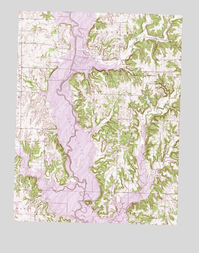
Ozawkie, KS USGS Topographic Map
Click on map above to begin viewing in our Map Viewer.

This topographic map contains these locations and features:
Feature Name Type Latitude Longitude GNIS ID View Map
Camp JayhawkLocaleN39.2031°W95.4022°480354View Map
City of OzawkieCivilN39.2356°W95.4651°2396122View Map
Delaware State ParkParkN39.1611°W95.4697°478486View Map
Evans CreekStreamN39.1489°W95.3997°478516View Map
Fairview Township Fire Department District 6BuildingN39.1805°W95.4172°2111313View Map
Fishpond CreekStreamN39.2350°W95.4094°478335View Map
HilldalePopulated PlaceN39.1819°W95.4761°484914View Map
Hilldale SouthPopulated PlaceN39.1750°W95.4766°484913View Map
Indian RidgePopulated PlaceN39.2181°W95.4753°484908View Map
Jacksonville (historical)LocaleN39.1806°W95.4461°482261View Map
Jefferson CountyCivilN39.2358°W95.3834°485008View Map
Jefferson County Sewer District Number 6LocaleN39.2386°W95.4233°2511221View Map
Jefferson County Sewer District Number 7LocaleN39.2028°W95.4442°2511222View Map
Keystone Learning Services SchoolSchoolN39.2299°W95.4620°2506606View Map
Lake Perry Country ClubLocaleN39.1622°W95.4710°2510111View Map
Lake RidgePopulated PlaceN39.1653°W95.4725°484911View Map
Lake ShorePopulated PlaceN39.2431°W95.4239°484909View Map
Lakeside VillagePopulated PlaceN39.1753°W95.4214°484910View Map
Lakeside Village CampgroundsLocaleN39.1816°W95.4264°2509585View Map
Little Slough CreekStreamN39.2147°W95.4547°478490View Map
Longview Public Use AreaParkN39.1847°W95.4447°478485View Map
Lowry School (historical)SchoolN39.2089°W95.3953°478488View Map
Old Town Public Use AreaParkN39.2250°W95.4378°480351View Map
Olive Branch CemeteryCemeteryN39.1505°W95.4727°478487View Map
OzawkiePopulated PlaceN39.2333°W95.4669°478489View Map
Ozawkie CemeteryCemeteryN39.2225°W95.4331°2673286View Map
Ozawkie Post OfficePost OfficeN39.1756°W95.4225°2510309View Map
Ozawkie Township Fire District 7BuildingN39.2363°W95.4691°2111715View Map
Ozawkie Township HallBuildingN39.2383°W95.4693°2509788View Map
Perry LakeReservoirN39.1773°W95.4517°478491View Map
Perry Public Use AreaParkN39.1319°W95.4072°478494View Map
Perry State ParkParkN39.1625°W95.4725°480353View Map
Perry State Park Cottonwood Bridge CampgroundLocaleN39.1354°W95.4767°2624980View Map
Perry State Park Cougar Pass CampgroundLocaleN39.1373°W95.4797°2624981View Map
Perry State Park Eagle Landing CampgroundLocaleN39.1459°W95.4836°2624982View Map
Perry State Park Hobie Cove CampgroundLocaleN39.1345°W95.4732°2624983View Map
Perry State Park North Boat RampLocaleN39.1520°W95.4924°2624876View Map
Perry State Park OfficeBuildingN39.1444°W95.4897°2625205View Map
Perry State Park Pelican Point CampgroundLocaleN39.1375°W95.4745°2624984View Map
Perry State Park South Boat RampLocaleN39.1383°W95.4761°2624877View Map
Perry State Park Wild Horse CampgroundLocaleN39.1480°W95.4954°2624985View Map
Pleasant Hill (historical)LocaleN39.2222°W95.4961°481974View Map
Rock Creek MarinaHarborN39.1511°W95.4776°2510066View Map
Round MoundPillarN39.1256°W95.4064°478492View Map
Slough Creek Public Use AreaParkN39.1347°W95.4308°478484View Map
Slough Creek Public Use AreaParkN39.1347°W95.4294°480355View Map
Township of FairviewCivilN39.1797°W95.4314°478496View Map
West ShorePopulated PlaceN39.1889°W95.4772°484912View Map
Wind-N-WaveLocaleN39.1625°W95.4641°480352View Map

Note: Coordinates in the location and feature list above are referenced to NAD83 datum.


Copyright (C) 2008-2025 Ryan Niemi / Sunset Dynamics ... All Rights Reserved