TopoQuest Logo
Do you find TopoQuest useful?
Help keep TopoQuest running and adding new maps/features by donating!
Bitcoin:  19c7KJd3qBynnjoSw5npx9KScwjBe4ifkT
Litecoin:  LXs6TkuXGGXo1vDsWCkWVdjQX94eUKd6ui
Home View Maps Find Maps Find Places Resources & Links


Merrill, Oregon Topographic Map

USGS Map Title: Merrill, OR
USGS Map MRC: 42121A5
DRG (GeoTIFF) Download: o42121a5.tif


Neighboring USGS Topographic Map Quads:


  Altamont, OR  
42121B6
 

  Dairy, OR  
42121B5
 

  Bonanza, OR  
42121B4
 

  Lost River, OR  
42121A6
 

  Merrill, OR  
42121A5
 

  Malin, OR  
42121A4
 

  Lower Klamath Lake, CA  
41121H6
 

  Hatfield, CA  
41121H5
 

  Tulelake, CA  
41121H4


Map MRC Location:

N43°
W122°
N43°
W121°
H8 H7 H6 H5 H4 H3 H2 H1
G8 G7 G6 G5 G4 G3 G2 G1
F8 F7 F6 F5 F4 F3 F2 F1
E8 E7 E6 E5 E4 E3 E2 E1
D8 D7 D6 D5 D4 D3 D2 D1
C8 C7 C6 C5 C4 C3 C2 C1
B8 B7 B6 B5 B4 B3 B2 B1
A8 A7 A6 A5 A4 A3 A2 A1
N42°
W122°
N42°
W121°

Merrill, OR USGS 1:24K Topographic Map Preview:
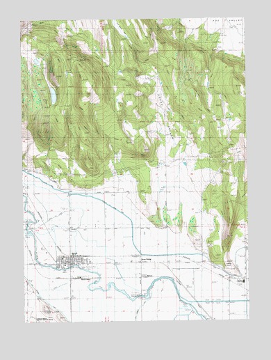
Merrill, OR USGS Topographic Map
Click on map above to begin viewing in our Map Viewer.

This topographic map contains these locations and features:
Feature Name Type Latitude Longitude GNIS ID View Map
Adams PointRidgeN42.0224°W121.5089°1116770View Map
Anderson-Rose Diversion DamDamN42.0099°W121.5811°1131563View Map
Anderson-Rose PoolReservoirN42.0099°W121.5811°1131562View Map
City of MerrillCivilN42.0260°W121.6008°2411085View Map
Clinton (historical)LocaleN42.0215°W121.5997°1132683View Map
Dodds HollowValleyN42.0638°W121.5489°1119986View Map
G-Three CanalCanalN42.0388°W121.5572°1121029View Map
Hill Reservoir Number OneReservoirN42.0957°W121.6192°1132665View Map
Hill Reservoir Number TwoReservoirN42.1016°W121.6006°1132666View Map
Hill-Johnson ReservoirReservoirN42.1080°W121.6175°1132668View Map
J-1 CanalCanalN42.0035°W121.5419°1122314View Map
Johnston Reservoir Number TwoReservoirN42.1030°W121.6004°1132667View Map
Klamath County Library Merrill BranchBuildingN42.0236°W121.6033°2698998View Map
Lost River High SchoolSchoolN42.0158°W121.5039°1162472View Map
MalonePopulated PlaceN42.0196°W121.5594°1136510View Map
MerrillPopulated PlaceN42.0252°W121.6006°1124069View Map
Merrill City HallBuildingN42.0256°W121.5978°2699998View Map
Merrill Elementary SchoolSchoolN42.0263°W121.6044°2453237View Map
Merrill IOOF CemeteryCemeteryN42.0221°W121.5914°1135188View Map
Merrill Police DepartmentBuildingN42.0256°W121.5977°2737686View Map
Merrill Post OfficePost OfficeN42.0242°W121.5991°1165626View Map
Merrill Public Works Department OfficeBuildingN42.0256°W121.5977°2699997View Map
Merrill Rural Fire Protection DistrictBuildingN42.0270°W121.6008°2576707View Map
Merrill SidingLocaleN42.0193°W121.5953°1166681View Map
Merrill Wastewater Treatment LagoonsLocaleN42.0189°W121.5874°2697089View Map
Stone BridgeBridgeN42.0282°W121.5605°1637862View Map
Tule Lake Post Office (historical)Post OfficeN42.0104°W121.5789°1164741View Map
Van Brimmer CanalCanalN42.0015°W121.6014°1128501View Map
Van Meter FlatFlatN42.1224°W121.5733°1128506View Map
Whitney BridgeBridgeN42.0221°W121.5247°1162471View Map

Note: Coordinates in the location and feature list above are referenced to NAD83 datum.


Copyright (C) 2008-2024 Ryan Niemi / Sunset Dynamics ... All Rights Reserved