TopoQuest Logo
Do you find TopoQuest useful?
Help keep TopoQuest running and adding new maps/features by donating!
Bitcoin:  19c7KJd3qBynnjoSw5npx9KScwjBe4ifkT
Litecoin:  LXs6TkuXGGXo1vDsWCkWVdjQX94eUKd6ui
Home View Maps Find Maps Find Places Resources & Links


Mexico West, Missouri Topographic Map

USGS Map Title: Mexico West, MO
USGS Map MRC: 39091B8
DRG (GeoTIFF) Download: o39091b8.tif


Neighboring USGS Topographic Map Quads:


  Rowena, MO  
39092C1
 

  Molino, MO  
39091C8
 

  Santa Fe, MO  
39091C7
 

  Centralia NE, MO  
39092B1
 

  Mexico West, MO  
39091B8
 

  Mexico East, MO  
39091B7
 

  Hatton, MO  
39092A1
 

  Auxvasse, MO  
39091A8
 

  Mexico SE, MO  
39091A7


Map MRC Location:

N40°
W92°
N40°
W91°
H8 H7 H6 H5 H4 H3 H2 H1
G8 G7 G6 G5 G4 G3 G2 G1
F8 F7 F6 F5 F4 F3 F2 F1
E8 E7 E6 E5 E4 E3 E2 E1
D8 D7 D6 D5 D4 D3 D2 D1
C8 C7 C6 C5 C4 C3 C2 C1
B8 B7 B6 B5 B4 B3 B2 B1
A8 A7 A6 A5 A4 A3 A2 A1
N39°
W92°
N39°
W91°

Mexico West, MO USGS 1:24K Topographic Map Preview:
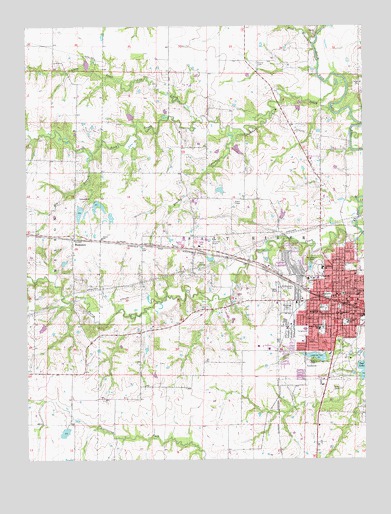
Mexico West, MO USGS Topographic Map
Click on map above to begin viewing in our Map Viewer.

This topographic map contains these locations and features:
Feature Name Type Latitude Longitude GNIS ID View Map
Big BranchStreamN39.2137°W91.9752°714138View Map
Brushy BranchStreamN39.2191°W91.9224°714878View Map
Carter Lake DamDamN39.1650°W91.9935°765414View Map
Carter School (historical)SchoolN39.2335°W91.8760°715449View Map
Davis CreekStreamN39.1903°W91.8763°749582View Map
Davis H. Hart Career CenterSchoolN39.1802°W91.8907°2649830View Map
Deimeke LakeReservoirN39.1954°W91.9054°761826View Map
Deimeke Lake DamDamN39.1950°W91.9068°761825View Map
Duly School (historical)SchoolN39.2406°W91.9274°744335View Map
Elmwood CemeteryCemeteryN39.1686°W91.9041°717553View Map
Eugene Field Elementary SchoolSchoolN39.1627°W91.8919°717650View Map
Fish BranchStreamN39.2448°W91.8935°717936View Map
Garfield School (historical)SchoolN39.1662°W91.8757°718342View Map
Hawthorne Elementary SchoolSchoolN39.1771°W91.8959°719246View Map
Hurdle School (historical)SchoolN39.1591°W91.9983°744338View Map
Jesse School (historical)SchoolN39.1678°W91.9399°744337View Map
Kallenbach and Becker Lake DamDamN39.2150°W91.9235°761847View Map
KJAB-FM (Mexico)TowerN39.1745°W91.8896°759026View Map
KWWR-FM (Mexico)TowerN39.1950°W91.9404°759078View Map
Lakeview ParkParkN39.1539°W91.8938°720765View Map
Lakeview Park LakeReservoirN39.1546°W91.8929°760293View Map
Little Skull Lick CreekStreamN39.2228°W91.9366°721320View Map
Locke LakeReservoirN39.1949°W91.9689°761308View Map
Locke Lake East DamDamN39.1967°W91.9702°761307View Map
Locke Lake North DamDamN39.2000°W91.9752°761309View Map
Locke Lake West DamDamN39.1984°W91.9785°760384View Map
Maple Grove School (historical)SchoolN39.2003°W91.9241°744336View Map
MexicoPopulated PlaceN39.1698°W91.8829°729554View Map
Mexico High SchoolSchoolN39.1779°W91.8909°2649827View Map
Mexico Middle SchoolSchoolN39.1624°W91.8972°2649829View Map
Mexico Police DepartmentBuildingN39.1741°W91.8812°2620291View Map
Mexico Post OfficePost OfficeN39.1718°W91.8867°2779532View Map
Missouri Power and Light DamDamN39.1550°W91.8902°760292View Map
Mrs Sam Locke LakeReservoirN39.1962°W91.9805°760385View Map
Number 102 DamDamN39.2017°W91.9285°760954View Map
Number 221 ReservoirReservoirN39.1987°W91.9731°761310View Map
Paul Veale LakeReservoirN39.1330°W91.9863°760726View Map
Plunkett ParkParkN39.1814°W91.8929°724675View Map
Saint Brendan SchoolSchoolN39.1670°W91.8846°725734View Map
Saint Brendans Catholic Church CemeteryCemeteryN39.1724°W91.9053°725733View Map
Simms School (historical)SchoolN39.1892°W91.9724°729651View Map
Skull Lick CreekStreamN39.2342°W91.8879°726515View Map
South Trails Shopping CenterLocaleN39.1467°W91.8918°741934View Map
SSM Health Saint Mary's Hospital - AudrainHospitalN39.1725°W91.8777°2655047View Map
Sunrise ChurchChurchN39.2475°W91.8929°729665View Map
ThompsonPopulated PlaceN39.1887°W91.9830°729673View Map
Thompson Post OfficePost OfficeN39.1892°W91.9829°2779520View Map
Township of Salt RiverCivilN39.2013°W91.9176°766246View Map
Trinity CemeteryCemeteryN39.2392°W91.9143°727780View Map
West PlazaLocaleN39.1717°W91.8893°741935View Map
Williams Dam EastDamN39.1350°W91.9852°760725View Map

Note: Coordinates in the location and feature list above are referenced to NAD83 datum.


Copyright (C) 2008-2024 Ryan Niemi / Sunset Dynamics ... All Rights Reserved