TopoQuest Logo
Do you find TopoQuest useful?
Help keep TopoQuest running and adding new maps/features by donating!
Bitcoin:  19c7KJd3qBynnjoSw5npx9KScwjBe4ifkT
Litecoin:  LXs6TkuXGGXo1vDsWCkWVdjQX94eUKd6ui
Home View Maps Find Maps Find Places Resources & Links


Mexico SE, Missouri Topographic Map

USGS Map Title: Mexico SE, MO
USGS Map MRC: 39091A7
DRG (GeoTIFF) Download: o39091a7.tif


Neighboring USGS Topographic Map Quads:


  Mexico West, MO  
39091B8
 

  Mexico East, MO  
39091B7
 

  Laddonia, MO  
39091B6
 

  Auxvasse, MO  
39091A8
 

  Mexico SE, MO  
39091A7
 

  Martinsburg, MO  
39091A6
 

  Kingdom City, MO  
38091H8
 

  Calwood, MO  
38091H7
 

  Williamsburg, MO  
38091H6


Map MRC Location:

N40°
W92°
N40°
W91°
H8 H7 H6 H5 H4 H3 H2 H1
G8 G7 G6 G5 G4 G3 G2 G1
F8 F7 F6 F5 F4 F3 F2 F1
E8 E7 E6 E5 E4 E3 E2 E1
D8 D7 D6 D5 D4 D3 D2 D1
C8 C7 C6 C5 C4 C3 C2 C1
B8 B7 B6 B5 B4 B3 B2 B1
A8 A7 A6 A5 A4 A3 A2 A1
N39°
W92°
N39°
W91°

Mexico SE, MO USGS 1:24K Topographic Map Preview:
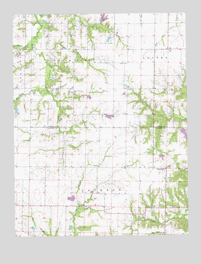
Mexico SE, MO USGS Topographic Map
Click on map above to begin viewing in our Map Viewer.

This topographic map contains these locations and features:
Feature Name Type Latitude Longitude GNIS ID View Map
Beaverdam CreekStreamN39.0823°W91.8513°748751View Map
Boles School (historical)SchoolN39.0387°W91.8335°754166View Map
Braun Lake DamDamN39.0784°W91.8218°762172View Map
Buckner Lake DamDamN39.0717°W91.8735°761488View Map
Don Woods LakeReservoirN39.0213°W91.8340°761558View Map
Ed Whalen LakeReservoirN39.0442°W91.7681°761545View Map
Hickory Grove School (historical)SchoolN39.0380°W91.7754°743448View Map
Jackson School (historical)SchoolN39.0828°W91.8320°744356View Map
Lockridge CemeteryCemeteryN39.1053°W91.8404°721379View Map
New Hope CemeteryCemeteryN39.0806°W91.8313°723232View Map
Number 222 ReservoirReservoirN39.0671°W91.8060°761314View Map
Pleasant Grove CemeteryCemeteryN39.0370°W91.7671°724478View Map
Rogers Lake DamDamN39.0684°W91.8085°761313View Map
Scattering ForkStreamN39.1081°W91.8618°752045View Map
Stauffer School (historical)SchoolN39.1187°W91.7618°744357View Map
Sunrise School (historical)SchoolN39.0828°W91.7729°744358View Map
Timber LakeLakeN39.1249°W91.8518°727665View Map
Township of JacksonCivilN39.0153°W91.8424°766379View Map
Union ChurchChurchN39.0817°W91.8313°727996View Map
Unity CemeteryCemeteryN39.1042°W91.7627°728054View Map
Watts BranchStreamN39.0809°W91.8510°738797View Map
Whalen DamDamN39.0448°W91.7685°761544View Map
White Oak BranchStreamN39.0952°W91.8478°738798View Map
Woods Dam NorthDamN39.0267°W91.8285°761541View Map
Woods Dam SouthDamN39.0217°W91.8318°761557View Map

Note: Coordinates in the location and feature list above are referenced to NAD83 datum.


Copyright (C) 2008-2025 Ryan Niemi / Sunset Dynamics ... All Rights Reserved