TopoQuest Logo
Do you find TopoQuest useful?
Help keep TopoQuest running and adding new maps/features by donating!
Bitcoin:  19c7KJd3qBynnjoSw5npx9KScwjBe4ifkT
Litecoin:  LXs6TkuXGGXo1vDsWCkWVdjQX94eUKd6ui
Home View Maps Find Maps Find Places Resources & Links


Meyersdale, Pennsylvania Topographic Map

USGS Map Title: Meyersdale, PA
USGS Map MRC: 39079G1
DRG (GeoTIFF) Download: o39079g1.tif


Neighboring USGS Topographic Map Quads:


  Rockwood, PA  
39079H2
 

  Murdock, PA  
39079H1
 

  Berlin, PA  
39078H8
 

  Markleton, PA  
39079G2
 

  Meyersdale, PA  
39079G1
 

  Wittenberg, PA  
39078G8
 

  Grantsville, MD  
39079F2
 

  Avilton, MD  
39079F1
 

  Frostburg, MD  
39078F8


Map MRC Location:

N40°
W80°
N40°
W79°
H8 H7 H6 H5 H4 H3 H2 H1
G8 G7 G6 G5 G4 G3 G2 G1
F8 F7 F6 F5 F4 F3 F2 F1
E8 E7 E6 E5 E4 E3 E2 E1
D8 D7 D6 D5 D4 D3 D2 D1
C8 C7 C6 C5 C4 C3 C2 C1
B8 B7 B6 B5 B4 B3 B2 B1
A8 A7 A6 A5 A4 A3 A2 A1
N39°
W80°
N39°
W79°

Meyersdale, PA USGS 1:24K Topographic Map Preview:
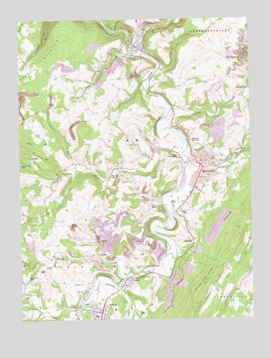
Meyersdale, PA USGS Topographic Map
Click on map above to begin viewing in our Map Viewer.

This topographic map contains these locations and features:
Feature Name Type Latitude Longitude GNIS ID View Map
Bigby CreekStreamN39.8606°W79.0600°1169609View Map
Bigby Run DamDamN39.8601°W79.0747°1194386View Map
Bigby Run LakeReservoirN39.8583°W79.0753°1194385View Map
Blue Lick CreekStreamN39.8370°W79.0406°1169886View Map
Borough of GarrettCivilN39.8644°W79.0618°1215587View Map
Borough of MeyersdaleCivilN39.8133°W79.0277°1215591View Map
Borough of SalisburyCivilN39.7534°W79.0844°1215596View Map
BoyntonPopulated PlaceN39.7667°W79.0667°1170105View Map
Boynton Post OfficePost OfficeN39.7672°W79.0678°2772612View Map
Brenneman LakeReservoirN39.7675°W79.1212°1170199View Map
Buffalo CreekStreamN39.8609°W79.0556°1170603View Map
Casselman GorgeValleyN39.8625°W79.0638°1201368View Map
Center ChurchChurchN39.8515°W79.0986°1171427View Map
Coal RunPopulated PlaceN39.7767°W79.0820°1172061View Map
Cold Spring School (historical)SchoolN39.8031°W79.0131°1206779View Map
ComptonPopulated PlaceN39.7617°W79.1223°1172276View Map
Cranberry RunStreamN39.8129°W79.0925°1172629View Map
Crossroad SchoolSchoolN39.8437°W79.0900°1205157View Map
Crossroads ChurchChurchN39.8429°W79.0903°1172764View Map
De Hay SchoolSchoolN39.7931°W79.1056°1205160View Map
Elklick CreekStreamN39.8198°W79.0350°1174138View Map
Engles MillPopulated PlaceN39.7529°W79.0611°1205042View Map
Flaugherty CreekStreamN39.8154°W79.0325°1174891View Map
Friendship FarmLocaleN39.7808°W79.0408°2585729View Map
Gangney School (historical)SchoolN39.8337°W79.0411°1206820View Map
GarrettPopulated PlaceN39.8631°W79.0581°1175463View Map
Garrett CemeteryCemeteryN39.8706°W79.0561°1175464View Map
Garrett Post OfficePost OfficeN39.8628°W79.0597°2772712View Map
Garrett Volunteer Fire Department - Station 620BuildingN39.8634°W79.0610°2644949View Map
Handwork School (historical)SchoolN39.8259°W79.1053°1205159View Map
Highland CemeteryCemeteryN39.8673°W79.0586°1177025View Map
HockingLocaleN39.8737°W79.0428°1205154View Map
Hunsrick SummitSummitN39.7840°W79.0328°1177602View Map
Laurel FallsPopulated PlaceN39.8170°W79.1189°1178930View Map
Laurel Falls LakeReservoirN39.8145°W79.1247°1192740View Map
Lichty SchoolSchoolN39.7717°W79.0547°1206822View Map
Lick Run School (historical)SchoolN39.8570°W79.1200°1205156View Map
Meadow RunStreamN39.7520°W79.0909°1180832View Map
Meadow RunStreamN39.7517°W79.0931°585783View Map
MeyersdalePopulated PlaceN39.8137°W79.0247°1180992View Map
Meyersdale Airport (historical)AirportN39.8487°W79.0186°1193758View Map
Meyersdale Area Ambulance AssociationBuildingN39.8053°W79.0313°2719545View Map
Meyersdale Borough Police DepartmentBuildingN39.8178°W79.0320°2780546View Map
Meyersdale Community HospitalHospitalN39.8091°W79.0252°2718079View Map
Meyersdale High SchoolSchoolN39.7973°W79.0406°1180993View Map
Meyersdale Post officePost OfficeN39.8157°W79.0263°2772828View Map
Meyersdale Volunteer Fire Department - Station 617BuildingN39.8142°W79.0269°2645860View Map
Miller RunStreamN39.8034°W79.0381°1181224View Map
Miller SchoolSchoolN39.8390°W79.0697°1205158View Map
Miller SchoolSchoolN39.7648°W79.0042°1206823View Map
Miller SchoolSchoolN39.7951°W79.0406°1206824View Map
Mountain View ChurchChurchN39.7645°W79.0956°1181966View Map
Piney CreekStreamN39.7648°W79.0700°1199313View Map
Piney CreekStreamN39.7646°W79.0714°586541View Map
Piney RunStreamN39.8704°W79.0684°1183942View Map
Pleasant Hill SchoolSchoolN39.7895°W79.0853°1206821View Map
Reformed CemeteryCemeteryN39.8181°W79.0156°1184854View Map
RomaniaPopulated PlaceN39.7934°W79.0447°1202110View Map
Saint Michaels ChurchChurchN39.7609°W79.0906°1186484View Map
Saint PaulPopulated PlaceN39.7756°W79.1061°1186543View Map
Saint Pauls CemeteryCemeteryN39.8631°W79.0100°1186555View Map
Saint Pauls ChurchChurchN39.7765°W79.1084°1206780View Map
SalisburyPopulated PlaceN39.7529°W79.0809°1186867View Map
Salisbury JunctionPopulated PlaceN39.8256°W79.0325°1186869View Map
Salisbury Post OfficePost OfficeN39.7532°W79.0816°2772959View Map
Salisbury Volunteer Fire Department - Station 618BuildingN39.7539°W79.0912°2644941View Map
Sandy Hollow School (historical)SchoolN39.8092°W79.0814°1205161View Map
Shaw MinesPopulated PlaceN39.7976°W79.0525°1213096View Map
South Side SchoolSchoolN39.8579°W79.0664°1205155View Map
Spook RunStreamN39.8134°W79.1031°1188190View Map
State Game Lands Number 231ParkN39.7659°W79.0245°1193446View Map
Summit MillsPopulated PlaceN39.8090°W79.0756°1189048View Map
Summit Post Office (historical)Post OfficeN39.8090°W79.0756°1214449View Map
Swamp CreekStreamN39.8548°W79.0478°1189127View Map
Township of SummitCivilN39.8343°W79.0610°1217065View Map
Tub Mill RunStreamN39.7534°W79.0931°1189895View Map
Union CemeteryCemeteryN39.8073°W79.0222°1190088View Map
Walker School (historical)SchoolN39.8520°W79.0128°1205153View Map
West MeyersdalePopulated PlaceN39.8145°W79.0347°1191068View Map
West SalisburyPopulated PlaceN39.7542°W79.0950°1191106View Map
White Oak ChurchChurchN39.7731°W79.1239°1191297View Map

Note: Coordinates in the location and feature list above are referenced to NAD83 datum.


Copyright (C) 2008-2025 Ryan Niemi / Sunset Dynamics ... All Rights Reserved