TopoQuest Logo
Do you find TopoQuest useful?
Help keep TopoQuest running and adding new maps/features by donating!
Bitcoin:  19c7KJd3qBynnjoSw5npx9KScwjBe4ifkT
Litecoin:  LXs6TkuXGGXo1vDsWCkWVdjQX94eUKd6ui
Home View Maps Find Maps Find Places Resources & Links


Berlin, Pennsylvania Topographic Map

USGS Map Title: Berlin, PA
USGS Map MRC: 39078H8
DRG (GeoTIFF) Download: o39078h8.tif


Neighboring USGS Topographic Map Quads:


  Somerset, PA  
40079A1
 

  Stoystown, PA  
40078A8
 

  Central City, PA  
40078A7
 

  Murdock, PA  
39079H1
 

  Berlin, PA  
39078H8
 

  New Baltimore, PA  
39078H7
 

  Meyersdale, PA  
39079G1
 

  Wittenberg, PA  
39078G8
 

  Fairhope, PA  
39078G7


Map MRC Location:

N40°
W79°
N40°
W78°
H8 H7 H6 H5 H4 H3 H2 H1
G8 G7 G6 G5 G4 G3 G2 G1
F8 F7 F6 F5 F4 F3 F2 F1
E8 E7 E6 E5 E4 E3 E2 E1
D8 D7 D6 D5 D4 D3 D2 D1
C8 C7 C6 C5 C4 C3 C2 C1
B8 B7 B6 B5 B4 B3 B2 B1
A8 A7 A6 A5 A4 A3 A2 A1
N39°
W79°
N39°
W78°

Berlin, PA USGS 1:24K Topographic Map Preview:
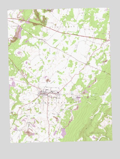
Berlin, PA USGS Topographic Map
Click on map above to begin viewing in our Map Viewer.

This topographic map contains these locations and features:
Feature Name Type Latitude Longitude GNIS ID View Map
BerlinPopulated PlaceN39.9206°W78.9578°1169300View Map
Berlin Area Ambulance AssociationBuildingN39.9223°W78.9533°2719650View Map
Berlin Borough Police DepartmentBuildingN39.9215°W78.9550°2780563View Map
Berlin Fire Department Station 628BuildingN39.9214°W78.9546°2644915View Map
Berlin Post OfficePost OfficeN39.9209°W78.9577°2772594View Map
Berlin-Brothersvalley Joint SchoolsSchoolN39.9165°W78.9425°1169303View Map
Borough of BerlinCivilN39.9215°W78.9509°1215582View Map
BrothertonPopulated PlaceN39.9715°W78.9578°1170353View Map
Cambria Four Mine StationLocaleN39.9992°W78.9453°1196923View Map
Davey StationLocaleN39.9987°W78.9453°1212736View Map
DowneyPopulated PlaceN39.9679°W78.8800°1173432View Map
Dream FieldAirportN39.9334°W78.9324°2770605View Map
East EndPopulated PlaceN39.9201°W78.9400°1197674View Map
East LibertyLocaleN39.9201°W78.9400°1206856View Map
Factory SchoolSchoolN39.9109°W78.9970°1196918View Map
Glades CreekStreamN39.9776°W78.9147°1175667View Map
Glessner SchoolSchoolN39.9617°W78.8997°1196922View Map
GoodtownPopulated PlaceN39.8934°W78.9784°1175818View Map
Hays RunStreamN39.9145°W78.9909°1176700View Map
Hillcrest GrangeLocaleN39.8770°W78.9697°1177091View Map
MacdonaldtonPopulated PlaceN39.9162°W78.9203°1180149View Map
Mineral SpringPopulated PlaceN39.9031°W78.9992°1204188View Map
Mostoller LandfillLocaleN39.9756°W78.9881°2725967View Map
Mount Zion-Hays CemeteryCemeteryN39.8751°W78.9736°1192974View Map
Niver JunctionPopulated PlaceN39.9017°W78.9620°1204292View Map
North View Airport (historical)AirportN39.9320°W78.9567°1193775View Map
Pennwood FarmsLocaleN39.9064°W78.9472°2585730View Map
Pike CemeteryCemeteryN39.9698°W78.9547°1183726View Map
Pine HillPopulated PlaceN39.8873°W78.9897°1183821View Map
Pine Hill Mine Number 1 StationLocaleN39.8887°W78.9781°1197600View Map
Pine Hill Mine Number 2 StationLocaleN39.8898°W78.9772°1197601View Map
Pine Hill Post Office (historical)Post OfficeN39.8873°W78.9897°1214327View Map
Pine Hill StationLocaleN39.8998°W78.9764°1196915View Map
Plank Road SchoolSchoolN39.9431°W78.9881°1196921View Map
Pleasant Valley SchoolSchoolN39.9384°W78.9189°1196916View Map
Reitz CreekStreamN39.9620°W78.9136°1184889View Map
RoxburyPopulated PlaceN39.9476°W78.9050°1185583View Map
Saint Gregorys ChurchChurchN39.9154°W78.9220°1185983View Map
Saint Michaels ChurchChurchN39.8865°W78.9895°1186485View Map
SalcoPopulated PlaceN39.9009°W78.9406°1201685View Map
Salco MinesLocaleN39.8895°W78.9345°1196919View Map
Sandy HollowValleyN39.9635°W78.9484°1186948View Map
Sandy Hollow SchoolSchoolN39.9637°W78.9606°1196917View Map
ShaftPopulated PlaceN39.9040°W78.9353°1187332View Map
Shipley Brothers MineMineN39.9484°W78.8847°1213103View Map
Stony Creek Post Office (historical)Post OfficeN39.9476°W78.9050°1214330View Map
Sugar Grove SchoolSchoolN39.9026°W78.9414°1196914View Map
Township of BrothersvalleyCivilN39.9092°W78.9786°1217045View Map
VietersburgLocaleN39.9259°W78.9492°1206855View Map
Walker SchoolSchoolN39.8784°W78.9525°1196920View Map

Note: Coordinates in the location and feature list above are referenced to NAD83 datum.


Copyright (C) 2008-2025 Ryan Niemi / Sunset Dynamics ... All Rights Reserved