TopoQuest Logo
Do you find TopoQuest useful?
Help keep TopoQuest running and adding new maps/features by donating!
Bitcoin:  19c7KJd3qBynnjoSw5npx9KScwjBe4ifkT
Litecoin:  LXs6TkuXGGXo1vDsWCkWVdjQX94eUKd6ui
Home View Maps Find Maps Find Places Resources & Links


Middleburg, North Carolina Topographic Map

USGS Map Title: Middleburg, NC
USGS Map MRC: 36078D3
DRG (GeoTIFF) Download: o36078d3.tif


Neighboring USGS Topographic Map Quads:


  Tungsten, NC  
36078E4
 

  John H Kerr Dam, VA  
36078E3
 

  Bracey, VA  
36078E2
 

  Townsville, NC  
36078D4
 

  Middleburg, NC  
36078D3
 

  Warrenton, NC  
36078D2
 

  Henderson, NC  
36078C4
 

  Vicksboro, NC  
36078C3
 

  Afton, NC  
36078C2


Map MRC Location:

N37°
W79°
N37°
W78°
H8 H7 H6 H5 H4 H3 H2 H1
G8 G7 G6 G5 G4 G3 G2 G1
F8 F7 F6 F5 F4 F3 F2 F1
E8 E7 E6 E5 E4 E3 E2 E1
D8 D7 D6 D5 D4 D3 D2 D1
C8 C7 C6 C5 C4 C3 C2 C1
B8 B7 B6 B5 B4 B3 B2 B1
A8 A7 A6 A5 A4 A3 A2 A1
N36°
W79°
N36°
W78°

Middleburg, NC USGS 1:24K Topographic Map Preview:
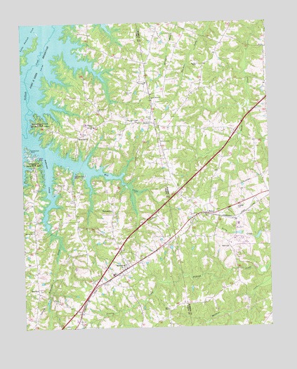
Middleburg, NC USGS Topographic Map
Click on map above to begin viewing in our Map Viewer.

This topographic map contains these locations and features:
Feature Name Type Latitude Longitude GNIS ID View Map
Anderson CreekStreamN36.4532°W78.3711°980179View Map
Bullocks ParkParkN36.4593°W78.3661°982238View Map
BullocksvillePopulated PlaceN36.4532°W78.3464°1019403View Map
Burchett ChapelChurchN36.4829°W78.2850°982268View Map
Burchett SchoolSchoolN36.4760°W78.2836°1007120View Map
DrewryPopulated PlaceN36.4593°W78.3100°1020028View Map
Drewry Volunteer Fire DepartmentBuildingN36.4604°W78.3069°2639017View Map
Flat RockPopulated PlaceN36.3913°W78.3678°1006203View Map
Flemington Road MarinaLocaleN36.4376°W78.3489°1001023View Map
George Blum HouseBuildingN36.3999°W78.3203°1965081View Map
JacksontownPopulated PlaceN36.4235°W78.3294°1020926View Map
Kearney HouseBuildingN36.3849°W78.2953°1965094View Map
Kerne ChapelChurchN36.3824°W78.3019°987930View Map
KingsburyBuildingN36.4063°W78.3681°1965095View Map
La Grange PlantationBuildingN36.4371°W78.3678°1965096View Map
Little Nutbush CreekStreamN36.4993°W78.3689°988722View Map
MansonPopulated PlaceN36.4218°W78.2831°989290View Map
Manson Post OfficePost OfficeN36.4220°W78.2825°2774029View Map
MiddleburgPopulated PlaceN36.3996°W78.3225°1021435View Map
Middleburg Community HouseBuildingN36.4013°W78.3203°1965080View Map
Middleburg Post OfficePost OfficeN36.3999°W78.3245°2774316View Map
Mill CreekStreamN36.4454°W78.3586°989936View Map
Morning Star ChurchChurchN36.4151°W78.3694°990256View Map
Mount Pleasant CemeteryCemeteryN36.4582°W78.3380°990524View Map
Mount Pleasant ChurhChurchN36.4643°W78.3353°990558View Map
New Hope CemeteryCemeteryN36.4512°W78.3053°990986View Map
North Vance Elementary SchoolSchoolN36.3971°W78.3286°1007995View Map
Nutbush SchoolSchoolN36.4574°W78.3383°991334View Map
Oak Level CemeteryCemeteryN36.4721°W78.3217°991425View Map
Oak Level ChurchChurchN36.4754°W78.3119°991431View Map
Peetes PondReservoirN36.4133°W78.2656°1000604View Map
Peetes Pond DamDamN36.4135°W78.2647°1000605View Map
Pleasant HillBuildingN36.4004°W78.3425°1965082View Map
Ridgeway CemeteryCemeteryN36.4229°W78.2661°993346View Map
Saint Johns ChurchChurchN36.4060°W78.3258°993967View Map
Saints Delight ChurchChurchN36.4601°W78.3197°994151View Map
Satterwhite PointCapeN36.4485°W78.3719°994365View Map
Satterwhite Recreation AreaParkN36.4379°W78.3686°994366View Map
Soul CityPopulated PlaceN36.4085°W78.2703°1022703View Map
Soul City Volunteer Rural Fire StationBuildingN36.4155°W78.2661°2639529View Map
Tarheel MarinaLocaleN36.4451°W78.3667°1001092View Map
TaroanoBuildingN36.3768°W78.3492°1965079View Map
Town of MiddleburgCivilN36.3989°W78.3234°2406156View Map
Township of MiddleburgCivilN36.4312°W78.3390°1027253View Map
Township of NutbushCivilN36.4692°W78.2792°1027282View Map
Warren Correctional InstitutionBuildingN36.4176°W78.2707°2769863View Map
Young Memorial ChurchChurchN36.4690°W78.3094°997734View Map

Note: Coordinates in the location and feature list above are referenced to NAD83 datum.


Copyright (C) 2008-2025 Ryan Niemi / Sunset Dynamics ... All Rights Reserved