TopoQuest Logo
Do you find TopoQuest useful?
Help keep TopoQuest running and adding new maps/features by donating!
Bitcoin:  19c7KJd3qBynnjoSw5npx9KScwjBe4ifkT
Litecoin:  LXs6TkuXGGXo1vDsWCkWVdjQX94eUKd6ui
Home View Maps Find Maps Find Places Resources & Links


Warrenton, North Carolina Topographic Map

USGS Map Title: Warrenton, NC
USGS Map MRC: 36078D2
DRG (GeoTIFF) Download: o36078d2.tif


Neighboring USGS Topographic Map Quads:


  John H Kerr Dam, VA  
36078E3
 

  Bracey, VA  
36078E2
 

  South Hill SE, VA  
36078E1
 

  Middleburg, NC  
36078D3
 

  Warrenton, NC  
36078D2
 

  Macon, NC  
36078D1
 

  Vicksboro, NC  
36078C3
 

  Afton, NC  
36078C2
 

  Inez, NC  
36078C1


Map MRC Location:

N37°
W79°
N37°
W78°
H8 H7 H6 H5 H4 H3 H2 H1
G8 G7 G6 G5 G4 G3 G2 G1
F8 F7 F6 F5 F4 F3 F2 F1
E8 E7 E6 E5 E4 E3 E2 E1
D8 D7 D6 D5 D4 D3 D2 D1
C8 C7 C6 C5 C4 C3 C2 C1
B8 B7 B6 B5 B4 B3 B2 B1
A8 A7 A6 A5 A4 A3 A2 A1
N36°
W79°
N36°
W78°

Warrenton, NC USGS 1:24K Topographic Map Preview:
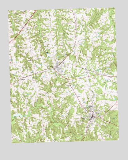
Warrenton, NC USGS Topographic Map
Click on map above to begin viewing in our Map Viewer.

This topographic map contains these locations and features:
Feature Name Type Latitude Longitude GNIS ID View Map
Boyd SchoolSchoolN36.3951°W78.1583°981788View Map
Camp KatzensteinLocaleN36.3943°W78.1292°982538View Map
Chapel Hill ChurchChurchN36.4990°W78.2311°983023View Map
Coffmans LakeReservoirN36.4701°W78.1830°1000663View Map
Coffmans Lake DamDamN36.4701°W78.1830°1000662View Map
Cooks ChapelChurchN36.4401°W78.1539°983474View Map
Fairview CemeteryCemeteryN36.4026°W78.1644°984912View Map
Good Shepherd ChurchChurchN36.4368°W78.2225°985797View Map
Hawkins SchoolSchoolN36.3971°W78.1636°986531View Map
Hawtree Volunteer Fire DepartmentBuildingN36.4886°W78.1707°2639412View Map
Hicks PondReservoirN36.4854°W78.1586°1005372View Map
Horse CreekStreamN36.3801°W78.1686°987091View Map
Kingdom Hall ChurchChurchN36.3879°W78.1603°987985View Map
Matthews CreekStreamN36.3999°W78.2442°989473View Map
NorlinaPopulated PlaceN36.4457°W78.1983°991179View Map
Norlina Middle SchoolSchoolN36.4482°W78.1953°1007019View Map
Norlina Police DepartmentBuildingN36.4441°W78.1930°2769574View Map
Norlina Post OfficePost OfficeN36.4447°W78.1936°2774050View Map
Norlina Volunteer Fire DepartmentBuildingN36.4456°W78.1957°2638305View Map
North Warrenton ChurchChurchN36.4074°W78.1567°991278View Map
Northside SchoolSchoolN36.4568°W78.1847°991302View Map
Oak ChapelChurchN36.3979°W78.1528°991342View Map
OinePopulated PlaceN36.4835°W78.2306°1021725View Map
Old Warrenton CemeteryCemeteryN36.4179°W78.1533°991621View Map
Owens CreekStreamN36.4007°W78.2022°991754View Map
Phoebes CreekStreamN36.3935°W78.1980°992155View Map
Poplar Mount (historical)LocaleN36.4740°W78.2278°1007011View Map
Providence ChurchChurchN36.4988°W78.1747°992886View Map
RidgewayPopulated PlaceN36.4357°W78.2367°1022289View Map
Ridgeway Post OfficePost OfficeN36.4359°W78.2370°2774067View Map
Ridgeway Volunteer Rural Fire StationBuildingN36.4367°W78.2360°2639074View Map
Rocky CreekStreamN36.4090°W78.2186°993576View Map
Rose CemeteryCemeteryN36.4499°W78.1936°993691View Map
Saint Josephs ChurchChurchN36.4168°W78.1714°993980View Map
Saint Pauls ChurchChurchN36.4510°W78.2464°994103View Map
Sawmill CreekStreamN36.4960°W78.1289°994395View Map
Snow HillPopulated PlaceN36.4163°W78.1883°1006375View Map
Town of NorlinaCivilN36.4452°W78.1952°2406997View Map
Town of WarrentonCivilN36.3994°W78.1574°2406832View Map
Township of HawtreeCivilN36.4928°W78.1466°1027280View Map
Township of Smith CreekCivilN36.4915°W78.2234°1027288View Map
Township of WarrentonCivilN36.3931°W78.1628°1027289View Map
Union ChapelChurchN36.4463°W78.2333°996442View Map
WARR-AM (Warrenton)TowerN36.4051°W78.1355°1018566View Map
Warren County Airport (historical)AirportN36.4224°W78.1386°998070View Map
Warren County Emergency Medical ServicesBuildingN36.4068°W78.1639°2720676View Map
Warren County High SchoolSchoolN36.4349°W78.1553°1007020View Map
Warren County Sheriff's OfficeBuildingN36.3933°W78.1349°2769723View Map
Warren Dale CemeteryCemeteryN36.4379°W78.1869°996802View Map
Warren PlainsPopulated PlaceN36.4426°W78.1603°1023117View Map
Warren Plains CemeteryCemeteryN36.4640°W78.1539°996805View Map
WarrentonPopulated PlaceN36.3985°W78.1553°996808View Map
Warrenton ChurchChurchN36.4282°W78.1803°996809View Map
Warrenton Police DepartmentBuildingN36.3975°W78.1557°2769735View Map
Warrenton Post OfficePost OfficeN36.4001°W78.1549°2773829View Map
Warrenton Rural Volunteer Fire DepartmentBuildingN36.3956°W78.1558°2638647View Map
Wesley Memorial ChurchChurchN36.4007°W78.1539°996974View Map
Whites Grove CemeteryCemeteryN36.4543°W78.2164°997253View Map
Whites Grove ChurchChurchN36.4524°W78.2230°997254View Map
WisePopulated PlaceN36.4865°W78.1708°997508View Map
Wise Post OfficePost OfficeN36.4888°W78.1711°2774300View Map
Zion ChurchChurchN36.4788°W78.2253°997784View Map

Note: Coordinates in the location and feature list above are referenced to NAD83 datum.


Copyright (C) 2008-2024 Ryan Niemi / Sunset Dynamics ... All Rights Reserved