TopoQuest Logo
Do you find TopoQuest useful?
Help keep TopoQuest running and adding new maps/features by donating!
Bitcoin:  19c7KJd3qBynnjoSw5npx9KScwjBe4ifkT
Litecoin:  LXs6TkuXGGXo1vDsWCkWVdjQX94eUKd6ui
Home View Maps Find Maps Find Places Resources & Links


Bracey, Virginia Topographic Map

USGS Map Title: Bracey, VA
USGS Map MRC: 36078E2
DRG (GeoTIFF) Download: o36078e2.tif


Neighboring USGS Topographic Map Quads:


  Baskerville, VA  
36078F3
 

  South Hill, VA  
36078F2
 

  La Crosse, VA  
36078F1
 

  John H Kerr Dam, VA  
36078E3
 

  Bracey, VA  
36078E2
 

  South Hill SE, VA  
36078E1
 

  Middleburg, NC  
36078D3
 

  Warrenton, NC  
36078D2
 

  Macon, NC  
36078D1


Map MRC Location:

N37°
W79°
N37°
W78°
H8 H7 H6 H5 H4 H3 H2 H1
G8 G7 G6 G5 G4 G3 G2 G1
F8 F7 F6 F5 F4 F3 F2 F1
E8 E7 E6 E5 E4 E3 E2 E1
D8 D7 D6 D5 D4 D3 D2 D1
C8 C7 C6 C5 C4 C3 C2 C1
B8 B7 B6 B5 B4 B3 B2 B1
A8 A7 A6 A5 A4 A3 A2 A1
N36°
W79°
N36°
W78°

Bracey, VA USGS 1:24K Topographic Map Preview:
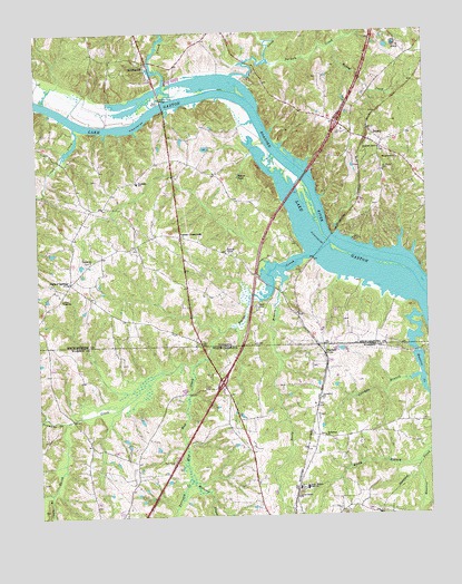
Bracey, VA USGS Topographic Map
Click on map above to begin viewing in our Map Viewer.

This topographic map contains these locations and features:
Feature Name Type Latitude Longitude GNIS ID View Map
Beaver PondLakeN36.5877°W78.1850°1462938View Map
BeechwoodPopulated PlaceN36.6174°W78.2136°1477103View Map
Bethlehem ChurchChurchN36.5204°W78.1583°981234View Map
Blue Mud CreekStreamN36.5401°W78.1983°981629View Map
BraceyPopulated PlaceN36.5996°W78.1431°1477137View Map
Bracey Post OfficePost OfficeN36.5951°W78.1384°2766342View Map
Bracy StationPopulated PlaceN36.5999°W78.1428°1500628View Map
Cabin BranchStreamN36.5063°W78.2464°982387View Map
Caroll Boyd School (historical)SchoolN36.5943°W78.1386°1500641View Map
Coleman BranchStreamN36.5357°W78.1275°983362View Map
Cotton CreekStreamN36.6007°W78.2372°1465277View Map
Cotton Creek School (historical)SchoolN36.5726°W78.2375°1500670View Map
Flat CreekStreamN36.6138°W78.1861°1466647View Map
Goodes Ferry BridgeBridgeN36.6076°W78.2097°1467224View Map
Grace CemeteryCemeteryN36.5565°W78.2417°1500705View Map
Grace ChurchChurchN36.5563°W78.2417°1467305View Map
Hawtree CreekStreamN36.5513°W78.1267°986535View Map
Hewey CreekStreamN36.6213°W78.1536°1467964View Map
Interchange 4CrossingN36.6013°W78.1528°1500720View Map
Jerusalem ChurchChurchN36.5304°W78.1594°987591View Map
Kingswood CemeteryCemeteryN36.5918°W78.1336°1500734View Map
Kingswood ChurchChurchN36.5918°W78.1336°1469030View Map
Locust Grove ChurchChurchN36.5049°W78.1675°988847View Map
Malones CreekStreamN36.5096°W78.2014°989263View Map
Martindale Executive AirparkAirportN36.5443°W78.1443°2679239View Map
Miles CreekStreamN36.6071°W78.2083°1470460View Map
Newmans CreekStreamN36.5249°W78.2411°991131View Map
North Warren High SchoolSchoolN36.5074°W78.1644°991277View Map
Palmer CrossroadsPopulated PlaceN36.5724°W78.2039°1477605View Map
Palmer SpringsPopulated PlaceN36.5607°W78.2392°1477606View Map
Palmer Springs Volunteer Fire Department Company 6BuildingN36.5607°W78.2396°2086163View Map
Parham CreekStreamN36.6174°W78.1744°1472055View Map
PaschallPopulated PlaceN36.5418°W78.1578°1021823View Map
Penuel ChurchChurchN36.5663°W78.2325°1472195View Map
Red Lawn School (historical)SchoolN36.6226°W78.2314°1500796View Map
Reedy BranchStreamN36.5624°W78.1719°993182View Map
River Ridge DamDamN36.5751°W78.1414°1490391View Map
River Ridge PondReservoirN36.5751°W78.1408°1490392View Map
Roanoke ChapelChurchN36.5679°W78.1883°1473292View Map
Roanoke School (historical)SchoolN36.5682°W78.1886°1500799View Map
Roanoke Zion ChurchChurchN36.5946°W78.1389°1473299View Map
Rocky BranchStreamN36.5135°W78.1283°993573View Map
Saint Johns School (historical)SchoolN36.5701°W78.2175°1500807View Map
Saint Marks CemeteryCemeteryN36.5893°W78.1386°1473815View Map
Saint Tammany Ferry (historical)CrossingN36.5876°W78.1639°1500814View Map
Smith CreekStreamN36.5671°W78.1631°1474277View Map
Smith CreekStreamN36.5704°W78.1556°1000722View Map
Southside SchoolSchoolN36.5863°W78.2175°1474916View Map
Tazewell (historical)Populated PlaceN36.6046°W78.2086°1500836View Map
Terrapin CreekStreamN36.5096°W78.2014°995932View Map
Whitby (historical)Populated PlaceN36.6168°W78.2083°1500846View Map

Note: Coordinates in the location and feature list above are referenced to NAD83 datum.


Copyright (C) 2008-2025 Ryan Niemi / Sunset Dynamics ... All Rights Reserved