TopoQuest Logo
Do you find TopoQuest useful?
Help keep TopoQuest running and adding new maps/features by donating!
Bitcoin:  19c7KJd3qBynnjoSw5npx9KScwjBe4ifkT
Litecoin:  LXs6TkuXGGXo1vDsWCkWVdjQX94eUKd6ui
Home View Maps Find Maps Find Places Resources & Links


Mifflintown, Pennsylvania Topographic Map

USGS Map Title: Mifflintown, PA
USGS Map MRC: 40077E4
DRG (GeoTIFF) Download: o40077e4.tif


Neighboring USGS Topographic Map Quads:


  Burnham, PA  
40077F5
 

  Alfarata, PA  
40077F4
 

  McClure, PA  
40077F3
 

  Lewistown, PA  
40077E5
 

  Mifflintown, PA  
40077E4
 

  Mexico, PA  
40077E3
 

  McCoysville, PA  
40077D5
 

  Spruce Hill, PA  
40077D4
 

  Ickesburg, PA  
40077D3


Map MRC Location:

N41°
W78°
N41°
W77°
H8 H7 H6 H5 H4 H3 H2 H1
G8 G7 G6 G5 G4 G3 G2 G1
F8 F7 F6 F5 F4 F3 F2 F1
E8 E7 E6 E5 E4 E3 E2 E1
D8 D7 D6 D5 D4 D3 D2 D1
C8 C7 C6 C5 C4 C3 C2 C1
B8 B7 B6 B5 B4 B3 B2 B1
A8 A7 A6 A5 A4 A3 A2 A1
N40°
W78°
N40°
W77°

Mifflintown, PA USGS 1:24K Topographic Map Preview:
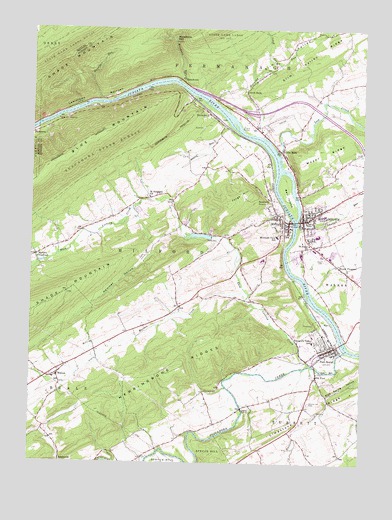
Mifflintown, PA USGS Topographic Map
Click on map above to begin viewing in our Map Viewer.

This topographic map contains these locations and features:
Feature Name Type Latitude Longitude GNIS ID View Map
Arch RockRidgeN40.6059°W77.4189°1201478View Map
Arch RockPopulated PlaceN40.6076°W77.4183°1192079View Map
Arch Rock SchoolSchoolN40.6062°W77.4192°1197141View Map
Beale Township Fire Department Company Station 5BuildingN40.5247°W77.4904°2645387View Map
Bell IslandIslandN40.5773°W77.4030°1192117View Map
Blue Spring HollowValleyN40.5197°W77.3871°1192170View Map
Borough of MifflinCivilN40.5686°W77.4045°1215309View Map
Borough of MifflintownCivilN40.5712°W77.3951°1215310View Map
Borough of Port RoyalCivilN40.5338°W77.3895°1215311View Map
Central Juniata Emergency Medical ServicesBuildingN40.5758°W77.3811°2645874View Map
Church Hill CemeteryCemeteryN40.5173°W77.3944°1192265View Map
Church Hill SchoolSchoolN40.5159°W77.3969°1197149View Map
Cuba MillsPopulated PlaceN40.5906°W77.4067°1192319View Map
DenholmPopulated PlaceN40.6009°W77.4333°1192349View Map
East Licking CreekStreamN40.5284°W77.3936°1192411View Map
Forge HillSummitN40.5748°W77.4255°1192479View Map
Friendship Fire Company Station 1BuildingN40.5344°W77.3870°2644963View Map
Hammer HollowValleyN40.5723°W77.4605°1192580View Map
HawstonePopulated PlaceN40.5951°W77.4986°1192592View Map
Hawstone OverlookLocaleN40.6040°W77.4633°1205147View Map
Horning RunStreamN40.5945°W77.4155°1192634View Map
Hunters CreekStreamN40.5276°W77.3922°1192647View Map
Jackson SchoolSchoolN40.5179°W77.4386°1197151View Map
Juniata CountyCivilN40.5311°W77.4022°1209180View Map
Juniata County Sheriff's OfficeBuildingN40.5707°W77.3972°2781050View Map
Juniata County Wildland FirefightersBuildingN40.5715°W77.3927°2645686View Map
Locust Grove SchoolSchoolN40.5576°W77.4205°1197145View Map
Lost CreekStreamN40.5884°W77.4061°1192852View Map
MacedoniaPopulated PlaceN40.6115°W77.4430°1192869View Map
Macedonia GapGapN40.6223°W77.4467°1192870View Map
Macedonia RunStreamN40.6101°W77.4444°1192871View Map
Maple Grove SchoolSchoolN40.5629°W77.4892°1197147View Map
Markee CreekStreamN40.5470°W77.4189°1192893View Map
Markee SchoolSchoolN40.5392°W77.4575°1197150View Map
Martins CrossroadsPopulated PlaceN40.5592°W77.4983°1200137View Map
MifflinPopulated PlaceN40.5695°W77.4028°1192930View Map
Mifflin Fire Department Station 3BuildingN40.5694°W77.4023°2644857View Map
Mifflin Post OfficePost OfficeN40.5698°W77.4031°2773205View Map
MifflintownPopulated PlaceN40.5698°W77.3969°1192931View Map
Mifflintown AirportAirportN40.6000°W77.4047°1194040View Map
Mifflintown Carrier Annex Post OfficePost OfficeN40.5720°W77.3916°2773206View Map
Mifflintown Hose Company Number 1 Station 2BuildingN40.5714°W77.3927°2644809View Map
Mifflintown Post OfficePost OfficeN40.5698°W77.3974°2772831View Map
Mount PleasantPopulated PlaceN40.5554°W77.3808°1192969View Map
Mountain View SchoolSchoolN40.5654°W77.4067°1192984View Map
Muddy RunStreamN40.5729°W77.4614°1212868View Map
Muddy RunStreamN40.5954°W77.4214°1192994View Map
Muddy Run SchoolSchoolN40.5837°W77.4244°1197144View Map
Old PortPopulated PlaceN40.5251°W77.3914°1193062View Map
Old Port SchoolSchoolN40.5229°W77.3894°1197148View Map
Pennsylvania State Police Troop G Lewistown StationBuildingN40.5986°W77.4120°2777322View Map
Port RoyalPopulated PlaceN40.5334°W77.3855°1193154View Map
Port Royal Emergency Medical Services Station 1BuildingN40.5345°W77.3868°2719539View Map
Port Royal Post OfficePost OfficeN40.5350°W77.3863°2772925View Map
Red Bank SchoolSchoolN40.5767°W77.4455°1197146View Map
Reno SchoolSchoolN40.5765°W77.3825°1197142View Map
Roaring RunStreamN40.6042°W77.4747°1193196View Map
RockvillePopulated PlaceN40.5762°W77.4094°1193210View Map
Saint Judes ChurchChurchN40.5631°W77.3947°1193256View Map
Saint Stephens ChurchChurchN40.5765°W77.4550°1193271View Map
Schweyer RunStreamN40.5687°W77.3992°1190991View Map
Shade MountainRangeN40.6084°W77.4955°1184520View Map
Slim ValleyValleyN40.6106°W77.4161°1187816View Map
Spigelmyer RunStreamN40.6231°W77.3905°1193419View Map
Spruce HillSummitN40.5026°W77.4308°1193423View Map
Suloff RunStreamN40.6148°W77.4064°1193498View Map
Township of FermanaghCivilN40.6157°W77.3926°1216581View Map
Township of MilfordCivilN40.5520°W77.4786°1216584View Map
Township of TurbettCivilN40.5047°W77.3769°1216588View Map
Tuscarora CreekStreamN40.5323°W77.3805°1193564View Map
Tuscarora Valley SchoolSchoolN40.5351°W77.3928°1193567View Map
Union CemeteryCemeteryN40.5589°W77.3888°1193580View Map
WalnutPopulated PlaceN40.5248°W77.4894°1193604View Map
Whitehall SchoolSchoolN40.6067°W77.3894°1197143View Map
Zooks DamReservoirN40.5576°W77.4308°1212869View Map
Zooks DamDamN40.5648°W77.4314°1198166View Map

Note: Coordinates in the location and feature list above are referenced to NAD83 datum.


Copyright (C) 2008-2025 Ryan Niemi / Sunset Dynamics ... All Rights Reserved