TopoQuest Logo
Do you find TopoQuest useful?
Help keep TopoQuest running and adding new maps/features by donating!
Bitcoin:  19c7KJd3qBynnjoSw5npx9KScwjBe4ifkT
Litecoin:  LXs6TkuXGGXo1vDsWCkWVdjQX94eUKd6ui
Home View Maps Find Maps Find Places Resources & Links


Burnham, Pennsylvania Topographic Map

USGS Map Title: Burnham, PA
USGS Map MRC: 40077F5
DRG (GeoTIFF) Download: o40077f5.tif


Neighboring USGS Topographic Map Quads:


  Centre Hall, PA  
40077G6
 

  Spring Mills, PA  
40077G5
 

  Coburn, PA  
40077G4
 

  Barrville, PA  
40077F6
 

  Burnham, PA  
40077F5
 

  Alfarata, PA  
40077F4
 

  Belleville, PA  
40077E6
 

  Lewistown, PA  
40077E5
 

  Mifflintown, PA  
40077E4


Map MRC Location:

N41°
W78°
N41°
W77°
H8 H7 H6 H5 H4 H3 H2 H1
G8 G7 G6 G5 G4 G3 G2 G1
F8 F7 F6 F5 F4 F3 F2 F1
E8 E7 E6 E5 E4 E3 E2 E1
D8 D7 D6 D5 D4 D3 D2 D1
C8 C7 C6 C5 C4 C3 C2 C1
B8 B7 B6 B5 B4 B3 B2 B1
A8 A7 A6 A5 A4 A3 A2 A1
N40°
W78°
N40°
W77°

Burnham, PA USGS 1:24K Topographic Map Preview:
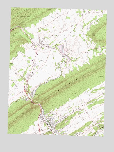
Burnham, PA USGS Topographic Map
Click on map above to begin viewing in our Map Viewer.

This topographic map contains these locations and features:
Feature Name Type Latitude Longitude GNIS ID View Map
Armagh Township Elementary SchoolSchoolN40.7153°W77.5853°1211750View Map
Beatty KnobSummitN40.7251°W77.5144°1192107View Map
Birch Hill CemeteryCemeteryN40.6467°W77.5661°1169636View Map
Borough of BurnhamCivilN40.6354°W77.5631°1215454View Map
Brice SchoolSchoolN40.6265°W77.5880°1197205View Map
Brown Township Elementary SchoolSchoolN40.6862°W77.5942°1211751View Map
Buck RunStreamN40.6251°W77.5608°1170549View Map
BurnhamPopulated PlaceN40.6387°W77.5686°1170727View Map
Burnham Fire CompanyBuildingN40.6360°W77.5660°2644733View Map
Burnham Post OfficePost OfficeN40.6318°W77.5688°2772620View Map
Camp JuniataLocaleN40.7062°W77.5069°1171038View Map
Church HillPopulated PlaceN40.6820°W77.5986°1171852View Map
Church Hill Census Designated PlaceCensusN40.6926°W77.5949°2584444View Map
Coffee RunStreamN40.6512°W77.6225°1172131View Map
Coxes Valley TrailTrailN40.7448°W77.6075°1172567View Map
Derry Elementary SchoolSchoolN40.6370°W77.5822°1211749View Map
Dry ValleyValleyN40.6260°W77.5583°1173557View Map
East Derry Volunteer Fire Company 2BuildingN40.6260°W77.5339°2645916View Map
Garden ViewPopulated PlaceN40.7098°W77.5911°1185463View Map
Hartman Center ChurchChurchN40.7190°W77.5981°1176610View Map
Havice CreekStreamN40.7262°W77.5297°1176661View Map
HoneyPopulated PlaceN40.7112°W77.5211°1197203View Map
Honey CreekStreamN40.6617°W77.5958°1177342View Map
Honey CreekPopulated PlaceN40.6898°W77.5589°1198907View Map
Honey Creek Lime QuarryMineN40.6975°W77.5494°2674897View Map
Hoopes SchoolSchoolN40.6403°W77.5150°1197204View Map
Hungry RunStreamN40.6306°W77.5642°1192645View Map
Kishacoquillas High SchoolSchoolN40.6892°W77.5942°1178552View Map
Kishacoquillas SchoolSchoolN40.7137°W77.5764°1178553View Map
KnobvillePopulated PlaceN40.7195°W77.5269°1178615View Map
Kratzer TrailTrailN40.7431°W77.5911°1178667View Map
Laurel CreekStreamN40.7026°W77.5508°1178927View Map
Lingle CreekStreamN40.7156°W77.5989°1179426View Map
Locke MillsPopulated PlaceN40.7106°W77.5233°1179757View Map
Lumber CityPopulated PlaceN40.6603°W77.6008°1180075View Map
Lumber City Census Designated PlaceCensusN40.6583°W77.6014°2584482View Map
MaitlandPopulated PlaceN40.6306°W77.5028°1192882View Map
Maitland ChurchChurchN40.6381°W77.5067°1180238View Map
Mammoth SpringSpringN40.6967°W77.5597°1207012View Map
Mann NarrowsGapN40.6553°W77.5928°1180275View Map
Mc Cardle Farm AirportAirportN40.6456°W77.5552°2443055View Map
McNitt School (historical)SchoolN40.7403°W77.5669°1197202View Map
Mifflin County Regional Police StationBuildingN40.6349°W77.5794°2780309View Map
MilroyPopulated PlaceN40.7140°W77.5906°1213988View Map
Milroy Census Designated PlaceCensusN40.7164°W77.5871°2389486View Map
Milroy Hose CompanyBuildingN40.7152°W77.5852°2645030View Map
Milroy Post OfficePost OfficeN40.7130°W77.5861°2772840View Map
Mount PleasantPopulated PlaceN40.7265°W77.6089°1181799View Map
Mount Pleasant Census Designated PlaceCensusN40.7270°W77.6060°2584491View Map
NagineyPopulated PlaceN40.7042°W77.5517°1182152View Map
New Lancaster ValleyValleyN40.7099°W77.5261°1193016View Map
Old Salem CemeteryCemeteryN40.7289°W77.5542°1182934View Map
Potlicker FlatsFlatN40.7223°W77.6053°1184329View Map
Potlicker Flats Census Designated PlaceCensusN40.7269°W77.6077°2612135View Map
ReedsvillePopulated PlaceN40.6640°W77.5958°1184838View Map
Reedsville Census Designated PlaceCensusN40.6645°W77.5930°2389737View Map
Reedsville Post OfficePost OfficeN40.6634°W77.5953°2772936View Map
Reedsville Volunteer Fire Company Station 6BuildingN40.6655°W77.5982°2645821View Map
RoseannPopulated PlaceN40.7103°W77.5897°1175435View Map
Saint Johns ChurchChurchN40.7384°W77.5331°1186140View Map
Saint Pauls ChurchChurchN40.6342°W77.5630°1186607View Map
Short Drive GapGapN40.7403°W77.5911°1187595View Map
ShraderPopulated PlaceN40.6978°W77.5536°1187612View Map
SiglervillePopulated PlaceN40.7395°W77.5325°1187659View Map
Siglerville Census Designated PlaceCensusN40.7368°W77.5319°2584508View Map
Straley KnobSummitN40.7159°W77.6081°1188849View Map
Tea CreekStreamN40.6628°W77.5972°1189327View Map
Township of DerryCivilN40.6329°W77.5367°1216828View Map
Treaster RunStreamN40.7103°W77.5289°1189737View Map
Treaster ValleyValleyN40.7279°W77.5268°1189738View Map
ViraPopulated PlaceN40.6515°W77.5330°1190441View Map
Will Johns GapGapN40.7476°W77.5778°1191442View Map
WoodlandPopulated PlaceN40.6945°W77.6250°1193693View Map
Woodlawn CemeteryCemeteryN40.7195°W77.5844°1191746View Map
YeagertownPopulated PlaceN40.6431°W77.5805°1191870View Map
Yeagertown Census Designated PlaceCensusN40.6413°W77.5803°2390549View Map
Yeagertown Fire Company Station 3BuildingN40.6407°W77.5784°2645235View Map
Yeagertown Post OfficePost OfficeN40.6392°W77.5767°2773053View Map

Note: Coordinates in the location and feature list above are referenced to NAD83 datum.


Copyright (C) 2008-2024 Ryan Niemi / Sunset Dynamics ... All Rights Reserved