TopoQuest Logo
Do you find TopoQuest useful?
Help keep TopoQuest running and adding new maps/features by donating!
Bitcoin:  19c7KJd3qBynnjoSw5npx9KScwjBe4ifkT
Litecoin:  LXs6TkuXGGXo1vDsWCkWVdjQX94eUKd6ui
Home View Maps Find Maps Find Places Resources & Links


Ickesburg, Pennsylvania Topographic Map

USGS Map Title: Ickesburg, PA
USGS Map MRC: 40077D3
DRG (GeoTIFF) Download: o40077d3.tif


Neighboring USGS Topographic Map Quads:


  Mifflintown, PA  
40077E4
 

  Mexico, PA  
40077E3
 

  Millerstown, PA  
40077E2
 

  Spruce Hill, PA  
40077D4
 

  Ickesburg, PA  
40077D3
 

  Newport, PA  
40077D2
 

  Andersonburg, PA  
40077C4
 

  Landisburg, PA  
40077C3
 

  Shermans Dale, PA  
40077C2


Map MRC Location:

N41°
W78°
N41°
W77°
H8 H7 H6 H5 H4 H3 H2 H1
G8 G7 G6 G5 G4 G3 G2 G1
F8 F7 F6 F5 F4 F3 F2 F1
E8 E7 E6 E5 E4 E3 E2 E1
D8 D7 D6 D5 D4 D3 D2 D1
C8 C7 C6 C5 C4 C3 C2 C1
B8 B7 B6 B5 B4 B3 B2 B1
A8 A7 A6 A5 A4 A3 A2 A1
N40°
W78°
N40°
W77°

Ickesburg, PA USGS 1:24K Topographic Map Preview:
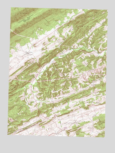
Ickesburg, PA USGS Topographic Map
Click on map above to begin viewing in our Map Viewer.

This topographic map contains these locations and features:
Feature Name Type Latitude Longitude GNIS ID View Map
Bilman RidgeRidgeN40.4276°W77.3655°1169628View Map
DunnLocaleN40.3979°W77.2708°1212875View Map
Elliotsburg Post OfficePost OfficeN40.3808°W77.3055°2773132View Map
ElliottsburgPopulated PlaceN40.3890°W77.2889°1174153View Map
ErlyPopulated PlaceN40.4090°W77.3389°1203528View Map
EshcolPopulated PlaceN40.4562°W77.3053°1174318View Map
Eshcol Memorial CemeteryCemeteryN40.4604°W77.2972°1174319View Map
Green ParkPopulated PlaceN40.3776°W77.3105°1176098View Map
IckesburgPopulated PlaceN40.4559°W77.3517°1177678View Map
Ickesburg Ambulance AssociationBuildingN40.4564°W77.3514°2719560View Map
Ickesburg Fire CompanyBuildingN40.4564°W77.3515°2645159View Map
Ickesburg High SchoolSchoolN40.4542°W77.3464°1177679View Map
Ickesburg Post OfficePost OfficeN40.4555°W77.3520°2772758View Map
Limestone RidgeRidgeN40.4084°W77.2667°1179360View Map
Little GermanyPopulated PlaceN40.3840°W77.2650°1179556View Map
Mahanoy HillSummitN40.3820°W77.2886°1180205View Map
MannsvillePopulated PlaceN40.4259°W77.2669°1180284View Map
Mannsville SchoolSchoolN40.4304°W77.2630°1180285View Map
Markel SchoolSchoolN40.4156°W77.2536°1197017View Map
Mount Pleasant SchoolSchoolN40.4779°W77.2722°1197015View Map
Mount Vernon ChurchChurchN40.4073°W77.3464°1181878View Map
Mount Zion ChurchChurchN40.3873°W77.2928°1181922View Map
Panther CreekStreamN40.4387°W77.3283°1183246View Map
Peach RidgeRidgeN40.4187°W77.3186°1183420View Map
Perry CountyCivilN40.3984°W77.2623°1213682View Map
Red SchoolSchoolN40.4017°W77.3364°1197014View Map
Ridge SchoolSchoolN40.4359°W77.2858°1197016View Map
RoseburgPopulated PlaceN40.4306°W77.3408°1204543View Map
RoseburgPopulated PlaceN40.4412°W77.3325°1212876View Map
School Number 4SchoolN40.4909°W77.2944°1187105View Map
Sherman RidgeRidgeN40.4567°W77.3178°1187489View Map
Texen SchoolSchoolN40.4120°W77.3000°1189379View Map
Thomas Field Airport (historical)AirportN40.3778°W77.3639°2442775View Map
Township of SavilleCivilN40.4330°W77.3516°1216949View Map
Tuscarora Wild AreaAreaN40.4834°W77.3580°1201695View Map
Waller Airport (historical)AirportN40.3904°W77.2844°1193968View Map
Walnut GrovePopulated PlaceN40.4573°W77.2597°1204893View Map
Wesley ChapelChurchN40.4576°W77.2622°1190854View Map

Note: Coordinates in the location and feature list above are referenced to NAD83 datum.


Copyright (C) 2008-2025 Ryan Niemi / Sunset Dynamics ... All Rights Reserved