TopoQuest Logo
Do you find TopoQuest useful?
Help keep TopoQuest running and adding new maps/features by donating!
Bitcoin:  19c7KJd3qBynnjoSw5npx9KScwjBe4ifkT
Litecoin:  LXs6TkuXGGXo1vDsWCkWVdjQX94eUKd6ui
Home View Maps Find Maps Find Places Resources & Links


Mikesville, Florida Topographic Map

USGS Map Title: Mikesville, FL
USGS Map MRC: 29082H5
DRG (GeoTIFF) Download: o29082h5.tif


Neighboring USGS Topographic Map Quads:


  Columbia, FL  
30082A6
 

  Ellisville, FL  
30082A5
 

  Lulu, FL  
30082A4
 

  Fort White, FL  
29082H6
 

  Mikesville, FL  
29082H5
 

  Worthington Springs, FL  
29082H4
 

  High Springs SW, FL  
29082G6
 

  High Springs, FL  
29082G5
 

  Alachua, FL  
29082G4


Map MRC Location:

N30°
W83°
N30°
W82°
H8 H7 H6 H5 H4 H3 H2 H1
G8 G7 G6 G5 G4 G3 G2 G1
F8 F7 F6 F5 F4 F3 F2 F1
E8 E7 E6 E5 E4 E3 E2 E1
D8 D7 D6 D5 D4 D3 D2 D1
C8 C7 C6 C5 C4 C3 C2 C1
B8 B7 B6 B5 B4 B3 B2 B1
A8 A7 A6 A5 A4 A3 A2 A1
N29°
W83°
N29°
W82°

Mikesville, FL USGS 1:24K Topographic Map Preview:
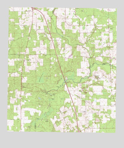
Mikesville, FL USGS Topographic Map
Click on map above to begin viewing in our Map Viewer.

This topographic map contains these locations and features:
Feature Name Type Latitude Longitude GNIS ID View Map
Black LakeLakeN29.8797°W82.5979°278912View Map
Buzzard Roost PrairieSwampN29.9286°W82.5865°279772View Map
Clay Electric Cooperative Bland SubstationBuildingN29.9503°W82.5067°2547740View Map
Damascus CemeteryCemeteryN29.8797°W82.5333°2547737View Map
Damascus Church (historical)ChurchN29.9164°W82.5393°281266View Map
Downing LakeLakeN29.8877°W82.5887°281741View Map
Francis R Sanchez GrantCivilN29.9208°W82.5193°300387View Map
Full Gospel of Jesus ChristChurchN29.9805°W82.5048°284257View Map
Greater New Hope Baptist ChurchChurchN29.9093°W82.5051°2447517View Map
Greater New Hope Missionary Baptist ChurchChurchN29.9094°W82.5051°287633View Map
Hammock BranchStreamN29.9302°W82.6068°283649View Map
Hogpen PondLakeN29.9084°W82.5710°284124View Map
Hopewell Church of God by FaithChurchN29.9803°W82.5086°2547742View Map
MikesvillePopulated PlaceN29.9466°W82.6021°294854View Map
Mikesville ChurchChurchN29.9713°W82.6015°286839View Map
Natural BridgeAreaN29.8939°W82.5785°287551View Map
New Hope CemeteryCemeteryN29.9100°W82.5050°2547739View Map
New Oak Grove Baptist ChurchChurchN29.8958°W82.5359°287663View Map
New Oak Grove CemeteryCemeteryN29.8953°W82.5367°2547738View Map
O'Leno State ParkParkN29.9169°W82.5843°294106View Map
Ogden PondLakeN29.9135°W82.5714°288060View Map
Olustee CreekStreamN29.9411°W82.5296°306158View Map
Pareners BranchStreamN29.9091°W82.5635°288492View Map
Philippi ChurchChurchN29.9522°W82.5823°288763View Map
River SinkLakeN29.9130°W82.5740°300400View Map
Robinson SinksBasinN29.9308°W82.5212°289801View Map
Saint John Missionary Baptist ChurchChurchN29.9972°W82.5387°290220View Map
San Francisco Potano (historical)Populated PlaceN29.8836°W82.5665°294491View Map
Sarah Community ParkParkN29.9792°W82.5050°2547743View Map
St. John CemeteryCemeteryN29.9975°W82.5392°2547744View Map
Sweet Water LakeLakeN29.8869°W82.5791°307636View Map
Vinzant LandingLocaleN29.9211°W82.5657°295690View Map

Note: Coordinates in the location and feature list above are referenced to NAD83 datum.


Copyright (C) 2008-2024 Ryan Niemi / Sunset Dynamics ... All Rights Reserved