TopoQuest Logo
Do you find TopoQuest useful?
Help keep TopoQuest running and adding new maps/features by donating!
Bitcoin:  19c7KJd3qBynnjoSw5npx9KScwjBe4ifkT
Litecoin:  LXs6TkuXGGXo1vDsWCkWVdjQX94eUKd6ui
Home View Maps Find Maps Find Places Resources & Links


Milbourn Ranch, New Mexico Topographic Map

USGS Map Title: Milbourn Ranch, NM
USGS Map MRC: 34106G2
DRG (GeoTIFF) Download: o34106g2.tif


Neighboring USGS Topographic Map Quads:


  Escabosa, NM  
34106H3
 

  Chilili, NM  
34106H2
 

  Moriarty South, NM  
34106H1
 

  Tajique, NM  
34106G3
 

  Milbourn Ranch, NM  
34106G2
 

  Estancia, NM  
34106G1
 

  Torreon, NM  
34106F3
 

  Ewing, NM  
34106F2
 

  Mountainair NE, NM  
34106F1


Map MRC Location:

N35°
W107°
N35°
W106°
H8 H7 H6 H5 H4 H3 H2 H1
G8 G7 G6 G5 G4 G3 G2 G1
F8 F7 F6 F5 F4 F3 F2 F1
E8 E7 E6 E5 E4 E3 E2 E1
D8 D7 D6 D5 D4 D3 D2 D1
C8 C7 C6 C5 C4 C3 C2 C1
B8 B7 B6 B5 B4 B3 B2 B1
A8 A7 A6 A5 A4 A3 A2 A1
N34°
W107°
N34°
W106°

Milbourn Ranch, NM USGS 1:24K Topographic Map Preview:
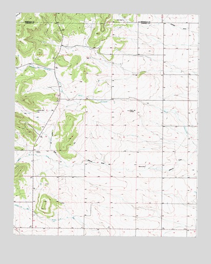
Milbourn Ranch, NM USGS Topographic Map
Click on map above to begin viewing in our Map Viewer.

This topographic map contains these locations and features:
Feature Name Type Latitude Longitude GNIS ID View Map
Arroyo de la MigaValleyN34.7651°W106.2106°924472View Map
Caņada de ChinchonteArroyoN34.8362°W106.2197°904402View Map
Caņada de la MigaArroyoN34.7595°W106.2317°904341View Map
Caņada de la PerraArroyoN34.7889°W106.2139°904345View Map
Caņon del PinoValleyN34.7889°W106.2136°904595View Map
Cedar Grove ChurchChurchN34.8514°W106.1536°887326View Map
Cerro del ConejoSummitN34.8206°W106.1714°897873View Map
Chief 1-A Pace MineMineN34.8526°W106.1547°917854View Map
Chief I PaceMineN34.7578°W106.1572°917852View Map
Drice I GarlandMineN34.7931°W106.2200°916614View Map
Esatancia 2 DehartMineN34.8484°W106.1564°916616View Map
Estancia 1 Kellogg MineMineN34.8526°W106.1547°940112View Map
Estancia 1 KutchinMineN34.8401°W106.1622°916612View Map
Estancia 1 RolandMineN34.8428°W106.1509°917855View Map
Estancia 3 DehartMineN34.8509°W106.1561°916618View Map
Estancia 4 DehartMineN34.8476°W106.1575°917851View Map
Estancia 5 DehartMineN34.8501°W106.1542°917853View Map
Garland CemeteryCemeteryN34.7972°W106.2357°889360View Map
Goodner RanchLocaleN34.8198°W106.2345°889506View Map
Lee I MilburnMineN34.7851°W106.1628°917848View Map
Meyers 1 MilburnMineN34.7664°W106.1772°916610View Map
Meyers 1 SmithMineN34.7589°W106.1645°916613View Map
Milbourn RanchLocaleN34.7892°W106.1600°892042View Map
Tijeras RanchLocaleN34.8714°W106.1761°895675View Map
Windmill Water WellWellN34.8689°W106.1847°919068View Map

Note: Coordinates in the location and feature list above are referenced to NAD83 datum.


Copyright (C) 2008-2025 Ryan Niemi / Sunset Dynamics ... All Rights Reserved