TopoQuest Logo
Do you find TopoQuest useful?
Help keep TopoQuest running and adding new maps/features by donating!
Bitcoin:  19c7KJd3qBynnjoSw5npx9KScwjBe4ifkT
Litecoin:  LXs6TkuXGGXo1vDsWCkWVdjQX94eUKd6ui
Home View Maps Find Maps Find Places Resources & Links


Tajique, New Mexico Topographic Map

USGS Map Title: Tajique, NM
USGS Map MRC: 34106G3
DRG (GeoTIFF) Download: o34106g3.tif


Neighboring USGS Topographic Map Quads:


  Mount Washington, NM  
34106H4
 

  Escabosa, NM  
34106H3
 

  Chilili, NM  
34106H2
 

  Bosque Peak, NM  
34106G4
 

  Tajique, NM  
34106G3
 

  Milbourn Ranch, NM  
34106G2
 

  Capilla Peak, NM  
34106F4
 

  Torreon, NM  
34106F3
 

  Ewing, NM  
34106F2


Map MRC Location:

N35°
W107°
N35°
W106°
H8 H7 H6 H5 H4 H3 H2 H1
G8 G7 G6 G5 G4 G3 G2 G1
F8 F7 F6 F5 F4 F3 F2 F1
E8 E7 E6 E5 E4 E3 E2 E1
D8 D7 D6 D5 D4 D3 D2 D1
C8 C7 C6 C5 C4 C3 C2 C1
B8 B7 B6 B5 B4 B3 B2 B1
A8 A7 A6 A5 A4 A3 A2 A1
N34°
W107°
N34°
W106°

Tajique, NM USGS 1:24K Topographic Map Preview:
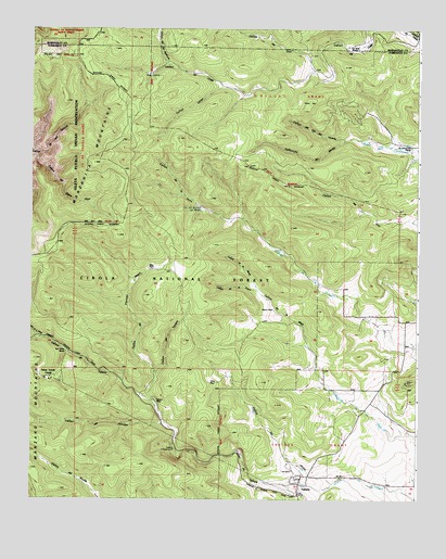
Tajique, NM USGS Topographic Map
Click on map above to begin viewing in our Map Viewer.

This topographic map contains these locations and features:
Feature Name Type Latitude Longitude GNIS ID View Map
Albuquerque TrailheadLocaleN34.7934°W106.3736°1986693View Map
Apache SpringSpringN34.7699°W106.3537°937050View Map
Baca Dirt TankReservoirN34.7922°W106.3074°1766264View Map
Barales SchoolLocaleN34.7987°W106.2561°903552View Map
Canon de la FueraValleyN34.8053°W106.3011°904512View Map
Caņon de la GallinaValleyN34.7931°W106.3709°904513View Map
Canon de la MigaValleyN34.7912°W106.2850°904517View Map
Caņon de la MulaValleyN34.8053°W106.3011°904520View Map
Caņon de la PerraValleyN34.8248°W106.3059°904521View Map
Caņon de OsoValleyN34.8642°W106.2834°904593View Map
Caņon de TajiqueValleyN34.7542°W106.2770°904556View Map
Caņon de TerreroValleyN34.7834°W106.3336°904600View Map
Caņon de Troncon NegroValleyN34.7759°W106.3334°904602View Map
Caņon del Agua AzulValleyN34.8423°W106.3728°904567View Map
Caņon del ApacheValleyN34.7701°W106.3309°904570View Map
Caņon del Ojo del VenadoValleyN34.8456°W106.2728°904589View Map
Caņon del Ojo RedondoValleyN34.8656°W106.3303°904590View Map
Caņon LargoValleyN34.8595°W106.3128°904658View Map
Caņon los JoyosValleyN34.7542°W106.2767°904608View Map
Caņoncito de MedioValleyN34.8456°W106.2731°904710View Map
Deer SpringSpringN34.8501°W106.2906°902633View Map
E-3658 Water WellWellN34.8706°W106.2739°921466View Map
El Chinchonte RanchLocaleN34.8437°W106.2525°906043View Map
Glover PlaceLocaleN34.8009°W106.2956°906572View Map
Glover SpringSpringN34.8104°W106.3076°913114View Map
Hawkins SpringSpringN34.7559°W106.3623°913112View Map
Inlow Youth CampLocaleN34.7820°W106.3672°907242View Map
King PlaceLocaleN34.7809°W106.3136°907556View Map
La Jaral RanchLocaleN34.8703°W106.2720°907662View Map
Nelson PlaceLocaleN34.7767°W106.3347°909050View Map
North End Trick TankReservoirN34.8711°W106.3594°2375290View Map
Ojo del Rancho del MedioSpringN34.8276°W106.3201°909301View Map
Ojo La CasaSpringN34.8631°W106.3364°902642View Map
Ojo los CasoSpringN34.8628°W106.3356°909303View Map
Ojo Terreo SpringSpringN34.7968°W106.3268°913113View Map
Old Tajique CemeteryCemeteryN34.7512°W106.2884°932205View Map
Pino TankReservoirN34.8263°W106.2686°913116View Map
Riley PlaceLocaleN34.8112°W106.3364°910173View Map
Riley Ranch SpringSpringN34.8120°W106.3367°914326View Map
Sun Valley RanchLocaleN34.7889°W106.3628°911486View Map
TajiquePopulated PlaceN34.7517°W106.2878°928822View Map
Tajique CabinLocaleN34.7659°W106.3278°911529View Map
Tajique CampgroundLocaleN34.7659°W106.3278°913111View Map
Tajique Catholic Church CemeteryCemeteryN34.7517°W106.2878°931250View Map
Tajique Census Designated PlaceCensusN34.7600°W106.3010°2410052View Map
Tajique Post OfficePost OfficeN34.7517°W106.2878°937778View Map
Tajique Weather StationLocaleN34.7517°W106.2878°931799View Map
Tejano SpringSpringN34.7706°W106.3248°1766265View Map
Three Tree SpringSpringN34.7845°W106.3652°1766266View Map
Town of Tajique GrantCivilN34.7595°W106.2809°911766View Map
White TankReservoirN34.8161°W106.2944°913115View Map

Note: Coordinates in the location and feature list above are referenced to NAD83 datum.


Copyright (C) 2008-2025 Ryan Niemi / Sunset Dynamics ... All Rights Reserved