TopoQuest Logo
Do you find TopoQuest useful?
Help keep TopoQuest running and adding new maps/features by donating!
Bitcoin:  19c7KJd3qBynnjoSw5npx9KScwjBe4ifkT
Litecoin:  LXs6TkuXGGXo1vDsWCkWVdjQX94eUKd6ui
Home View Maps Find Maps Find Places Resources & Links


Chilili, New Mexico Topographic Map

USGS Map Title: Chilili, NM
USGS Map MRC: 34106H2
DRG (GeoTIFF) Download: o34106h2.tif


Neighboring USGS Topographic Map Quads:


  Sedillo, NM  
35106A3
 

  Edgewood, NM  
35106A2
 

  Moriarty North, NM  
35106A1
 

  Escabosa, NM  
34106H3
 

  Chilili, NM  
34106H2
 

  Moriarty South, NM  
34106H1
 

  Tajique, NM  
34106G3
 

  Milbourn Ranch, NM  
34106G2
 

  Estancia, NM  
34106G1


Map MRC Location:

N35°
W107°
N35°
W106°
H8 H7 H6 H5 H4 H3 H2 H1
G8 G7 G6 G5 G4 G3 G2 G1
F8 F7 F6 F5 F4 F3 F2 F1
E8 E7 E6 E5 E4 E3 E2 E1
D8 D7 D6 D5 D4 D3 D2 D1
C8 C7 C6 C5 C4 C3 C2 C1
B8 B7 B6 B5 B4 B3 B2 B1
A8 A7 A6 A5 A4 A3 A2 A1
N34°
W107°
N34°
W106°

Chilili, NM USGS 1:24K Topographic Map Preview:
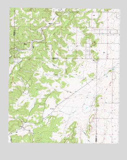
Chilili, NM USGS Topographic Map
Click on map above to begin viewing in our Map Viewer.

This topographic map contains these locations and features:
Feature Name Type Latitude Longitude GNIS ID View Map
080712224 Water WellWellN34.9381°W106.1517°919459View Map
080729322 Water WellWellN34.8889°W106.2311°919460View Map
090626244 Water WellWellN34.8889°W106.2311°919461View Map
116 Water WellWellN34.8817°W106.1872°921549View Map
120 Water WellWellN34.9389°W106.1834°921557View Map
121 Water WellWellN34.9264°W106.2061°921555View Map
20A Water WellWellN34.8887°W106.2314°921552View Map
310 Water WellWellN34.9756°W106.1436°927099View Map
Arroyo de ChililiArroyoN34.9348°W106.1445°903312View Map
Arroyo de YrisarriValleyN34.9689°W106.2231°903322View Map
AugustinePopulated PlaceN34.9370°W106.1942°898623View Map
Augustine Post Office (historical)Post OfficeN34.9370°W106.1942°938036View Map
BaldySummitN34.9678°W106.1531°898627View Map
Ballinger RanchLocaleN34.9853°W106.2022°886029View Map
Biplane Ranch AirportAirportN34.9226°W106.1645°2444037View Map
Buffalo SpringsSpringN34.9439°W106.1333°886864View Map
C Davis Place Census Designated PlaceCensusN34.9590°W106.1269°2584069View Map
Caņada de EscabosaArroyoN34.9600°W106.2364°904375View Map
Caņon de ChililiValleyN34.8909°W106.2278°904540View Map
Caņon de SavinaValleyN34.8837°W106.2461°904555View Map
ChililiPopulated PlaceN34.8895°W106.2328°928710View Map
Chilili CemeteryCemeteryN34.8894°W106.2326°931283View Map
Chilili Census Designated PlaceCensusN34.8974°W106.2331°2408025View Map
Chilili GrantCivilN34.8939°W106.2447°905098View Map
Chilili Post Office (historical)Post OfficeN34.8895°W106.2328°937521View Map
Clark RanchLocaleN34.9598°W106.1603°887646View Map
Danvik PlaceLocaleN34.9634°W106.2228°898649View Map
Dean RanchLocaleN34.9587°W106.1428°888253View Map
Dunn PlaceLocaleN34.9934°W106.1547°898652View Map
E-1439 Water WellWellN34.9434°W106.1367°927097View Map
E-2175 Water WellWellN34.8967°W106.2078°921468View Map
E-4151 Water WellWellN34.8887°W106.2320°921467View Map
Indian Hills Census Designated PlaceCensusN34.9832°W106.1398°2584089View Map
Ku Archaeological DistrictParkN34.8895°W106.2328°935801View Map
Manzano SpringsPopulated PlaceN34.9678°W106.2364°924440View Map
Manzano Springs Census Designated PlaceCensusN34.9614°W106.2326°2584177View Map
Marsh RanchLocaleN34.9520°W106.1522°891620View Map
MartinezPopulated PlaceN34.9992°W106.1911°898674View Map
Martinez Post Office (historical)Post OfficeN34.9992°W106.1911°938211View Map
Old ChililiPopulated PlaceN34.9064°W106.1972°898684View Map
Pine SpringsPopulated PlaceN34.9656°W106.2336°898689View Map
Saint John Nepomucene CemeteryCemeteryN34.8895°W106.2328°931249View Map
Thompson PlaceLocaleN34.9439°W106.1367°898697View Map

Note: Coordinates in the location and feature list above are referenced to NAD83 datum.


Copyright (C) 2008-2024 Ryan Niemi / Sunset Dynamics ... All Rights Reserved