TopoQuest Logo
Do you find TopoQuest useful?
Help keep TopoQuest running and adding new maps/features by donating!
Bitcoin:  19c7KJd3qBynnjoSw5npx9KScwjBe4ifkT
Litecoin:  LXs6TkuXGGXo1vDsWCkWVdjQX94eUKd6ui
Home View Maps Find Maps Find Places Resources & Links


Milburn, Kentucky Topographic Map

USGS Map Title: Milburn, KY
USGS Map MRC: 36088G8
DRG (GeoTIFF) Download: o36088g8.tif


Neighboring USGS Topographic Map Quads:


  Wickliffe, KY  
36089H1
 

  Blandville, KY  
36088H8
 

  Lovelaceville, KY  
36088H7
 

  Arlington, KY  
36089G1
 

  Milburn, KY  
36088G8
 

  Fancy Farm, KY  
36088G7
 

  Oakton, KY  
36089F1
 

  Clinton, KY  
36088F8
 

  Dublin, KY  
36088F7


Map MRC Location:

N37°
W89°
N37°
W88°
H8 H7 H6 H5 H4 H3 H2 H1
G8 G7 G6 G5 G4 G3 G2 G1
F8 F7 F6 F5 F4 F3 F2 F1
E8 E7 E6 E5 E4 E3 E2 E1
D8 D7 D6 D5 D4 D3 D2 D1
C8 C7 C6 C5 C4 C3 C2 C1
B8 B7 B6 B5 B4 B3 B2 B1
A8 A7 A6 A5 A4 A3 A2 A1
N36°
W89°
N36°
W88°

Milburn, KY USGS 1:24K Topographic Map Preview:
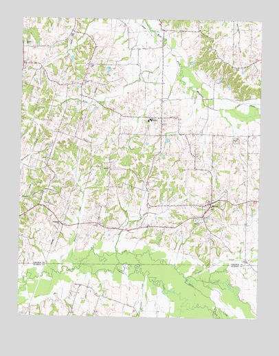
Milburn, KY USGS Topographic Map
Click on map above to begin viewing in our Map Viewer.

This topographic map contains these locations and features:
Feature Name Type Latitude Longitude GNIS ID View Map
Antioch (historical)Populated PlaceN36.8561°W88.9612°2743885View Map
Antioch ChurchChurchN36.8487°W88.9670°485973View Map
Arlington DivisionCivilN36.8062°W88.9285°1936855View Map
Bardwell CemeteryCemeteryN36.8646°W88.9988°486337View Map
Carlisle CountyCivilN36.8532°W88.9711°516866View Map
Central ChurchChurchN36.8314°W88.9256°489281View Map
Chalk SloughStreamN36.7551°W88.8964°489313View Map
Cypress CreekStreamN36.7706°W88.9681°490525View Map
East HopewellPopulated PlaceN36.7873°W88.9545°2743898View Map
Elsey CemeteryCemeteryN36.8674°W88.9751°491744View Map
Guess CreekStreamN36.7767°W88.9487°493457View Map
Holder CemeteryCemeteryN36.8559°W88.9645°494380View Map
Hopewell ChurchChurchN36.7887°W88.9592°494522View Map
Hopewell CreekStreamN36.7731°W88.9678°494538View Map
Horn CreekStreamN36.8614°W88.9226°494558View Map
Larkins Farm AirportAirportN36.8521°W88.9271°2444080View Map
Little CreekStreamN36.7675°W88.9090°496690View Map
MilburnPopulated PlaceN36.7987°W88.8998°498175View Map
Milburn Baptist GraveyardCemeteryN36.7965°W88.8996°2775655View Map
Milburn CemeteryCemeteryN36.8033°W88.8926°2775654View Map
Milburn Fire DepartmentBuildingN36.7976°W88.9019°2636279View Map
Obion ChurchChurchN36.7634°W88.9676°499766View Map
Russells CreekStreamN36.7676°W88.9342°502533View Map
Shiloh (historical)Populated PlaceN36.8117°W88.9533°2743921View Map
Shiloh CemeteryCemeteryN36.8127°W88.9536°2775586View Map
Shiloh ChurchChurchN36.8126°W88.9534°503372View Map
West HopewellPopulated PlaceN36.7934°W88.9824°2743927View Map

Note: Coordinates in the location and feature list above are referenced to NAD83 datum.


Copyright (C) 2008-2025 Ryan Niemi / Sunset Dynamics ... All Rights Reserved