TopoQuest Logo
Do you find TopoQuest useful?
Help keep TopoQuest running and adding new maps/features by donating!
Bitcoin:  19c7KJd3qBynnjoSw5npx9KScwjBe4ifkT
Litecoin:  LXs6TkuXGGXo1vDsWCkWVdjQX94eUKd6ui
Home View Maps Find Maps Find Places Resources & Links


Clinton, Kentucky Topographic Map

USGS Map Title: Clinton, KY
USGS Map MRC: 36088F8
DRG (GeoTIFF) Download: o36088f8.tif


Neighboring USGS Topographic Map Quads:


  Arlington, KY  
36089G1
 

  Milburn, KY  
36088G8
 

  Fancy Farm, KY  
36088G7
 

  Oakton, KY  
36089F1
 

  Clinton, KY  
36088F8
 

  Dublin, KY  
36088F7
 

  Cayce, KY  
36089E1
 

  Crutchfield, KY  
36088E8
 

  Water Valley, KY  
36088E7


Map MRC Location:

N37°
W89°
N37°
W88°
H8 H7 H6 H5 H4 H3 H2 H1
G8 G7 G6 G5 G4 G3 G2 G1
F8 F7 F6 F5 F4 F3 F2 F1
E8 E7 E6 E5 E4 E3 E2 E1
D8 D7 D6 D5 D4 D3 D2 D1
C8 C7 C6 C5 C4 C3 C2 C1
B8 B7 B6 B5 B4 B3 B2 B1
A8 A7 A6 A5 A4 A3 A2 A1
N36°
W89°
N36°
W88°

Clinton, KY USGS 1:24K Topographic Map Preview:
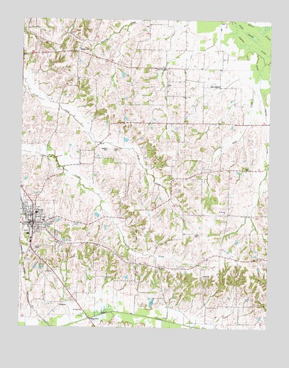
Clinton, KY USGS Topographic Map
Click on map above to begin viewing in our Map Viewer.

This topographic map contains these locations and features:
Feature Name Type Latitude Longitude GNIS ID View Map
BuggPopulated PlaceN36.6856°W88.9099°2743893View Map
Bugg CreekStreamN36.7367°W88.8812°488338View Map
Central SchoolSchoolN36.6681°W88.9884°489291View Map
City of ClintonCivilN36.6662°W88.9939°2404077View Map
ClintonPopulated PlaceN36.6673°W88.9934°489694View Map
Clinton - Hickman County Ambulance ServiceBuildingN36.6701°W88.9915°2719080View Map
Clinton DivisionCivilN36.6642°W88.9345°1936939View Map
Clinton Fire DepartmentBuildingN36.6677°W88.9933°2636297View Map
Clinton Police DepartmentBuildingN36.6666°W88.9948°2767564View Map
Clinton-Hickman County AirportAirportN36.6384°W88.9984°517355View Map
Hays CemeteryCemeteryN36.6898°W88.8850°493932View Map
Hickman CountyCivilN36.6782°W88.9762°516899View Map
Hickman County Intermediate Care FacilityHospitalN36.6618°W88.9940°2660406View Map
Hickman County Sheriff's OfficeBuildingN36.6667°W88.9942°2767436View Map
Hickman Fire and RescueBuildingN36.6562°W88.9925°2637273View Map
Johnson GraveyardCemeteryN36.7476°W88.9386°2775541View Map
Little Cypress CreekStreamN36.7403°W88.8862°496697View Map
McWhort CemeteryCemeteryN36.6976°W88.9567°497952View Map
Mount Moriah CemeteryCemeteryN36.6493°W88.9304°2775594View Map
Mount Moriah ChurchChurchN36.6495°W88.9295°498774View Map
Mount Pleasant CemeteryCemeteryN36.6714°W88.8986°2775591View Map
Mount Pleasant ChurchChurchN36.6714°W88.8967°498829View Map
Mount Veron ChurchChurchN36.6320°W88.9684°498902View Map
New CypressPopulated PlaceN36.7306°W88.9267°499309View Map
Old CypressPopulated PlaceN36.7234°W88.8998°508742View Map
Shiloh CemeteryCemeteryN36.7229°W88.9276°2775540View Map
Shiloh ChurchChurchN36.7231°W88.9262°503370View Map
Spring HillPopulated PlaceN36.7373°W88.9717°504141View Map
Spring Hill CemeteryCemeteryN36.7376°W88.9731°2775539View Map
Trinity ChapelChurchN36.6573°W88.9923°505501View Map
Vivrett CemeteryCemeteryN36.6971°W88.9534°506072View Map

Note: Coordinates in the location and feature list above are referenced to NAD83 datum.


Copyright (C) 2008-2025 Ryan Niemi / Sunset Dynamics ... All Rights Reserved