TopoQuest Logo
Do you find TopoQuest useful?
Help keep TopoQuest running and adding new maps/features by donating!
Bitcoin:  19c7KJd3qBynnjoSw5npx9KScwjBe4ifkT
Litecoin:  LXs6TkuXGGXo1vDsWCkWVdjQX94eUKd6ui
Home View Maps Find Maps Find Places Resources & Links


Mill Creek, Illinois Topographic Map

USGS Map Title: Mill Creek, IL
USGS Map MRC: 37089C3
DRG (GeoTIFF) Download: o37089c3.tif


Neighboring USGS Topographic Map Quads:


  Ware, IL  
37089D4
 

  Jonesboro, IL  
37089D3
 

  Anna, IL  
37089D2
 

  McClure, IL  
37089C4
 

  Mill Creek, IL  
37089C3
 

  Dongola, IL  
37089C2
 

  Thebes, IL  
37089B4
 

  Tamms, IL  
37089B3
 

  Pulaski, IL  
37089B2


Map MRC Location:

N38°
W90°
N38°
W89°
H8 H7 H6 H5 H4 H3 H2 H1
G8 G7 G6 G5 G4 G3 G2 G1
F8 F7 F6 F5 F4 F3 F2 F1
E8 E7 E6 E5 E4 E3 E2 E1
D8 D7 D6 D5 D4 D3 D2 D1
C8 C7 C6 C5 C4 C3 C2 C1
B8 B7 B6 B5 B4 B3 B2 B1
A8 A7 A6 A5 A4 A3 A2 A1
N37°
W90°
N37°
W89°

Mill Creek, IL USGS 1:24K Topographic Map Preview:
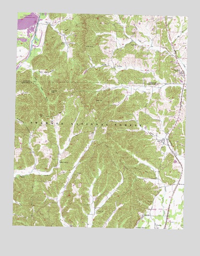
Mill Creek, IL USGS Topographic Map
Click on map above to begin viewing in our Map Viewer.

This topographic map contains these locations and features:
Feature Name Type Latitude Longitude GNIS ID View Map
Bass Hill Lookout TowerTowerN37.3217°W89.3181°424604View Map
Birk-McRite QuarryMineN37.2745°W89.3270°1974678View Map
Burner HillSummitN37.2856°W89.2812°405235View Map
Cummins CemeteryCemeteryN37.3142°W89.3479°406891View Map
Delta SchoolSchoolN37.2895°W89.3415°407113View Map
Dogwood FlatsFlatN37.3292°W89.3501°407286View Map
Dry HollowValleyN37.3048°W89.2702°407429View Map
ElcoPopulated PlaceN37.3006°W89.2659°407839View Map
Elco Election Precinct (historical)CivilN37.2987°W89.2876°1928490View Map
Elco Post OfficePost OfficeN37.3006°W89.2659°1808562View Map
Gauble SchoolSchoolN37.3242°W89.2776°408932View Map
Hazelwood SchoolSchoolN37.2764°W89.2617°409993View Map
Hogskin BottomsFlatN37.2509°W89.2809°410365View Map
Honey CemeteryCemeteryN37.2598°W89.3123°410470View Map
Italian HillSummitN37.3245°W89.3137°406922View Map
Lingle CreekStreamN37.3506°W89.2579°412241View Map
Lingle SchoolSchoolN37.3573°W89.2873°412242View Map
Lone Star MineMineN37.3039°W89.3201°1974811View Map
Lylerle SchoolSchoolN37.3698°W89.3529°412757View Map
McClure CemeteryCemeteryN37.2831°W89.3709°413207View Map
McCrite CemeteryCemeteryN37.2817°W89.3290°413239View Map
McDaniel SchoolSchoolN37.2576°W89.3165°413244View Map
Mill CreekPopulated PlaceN37.3417°W89.2526°413536View Map
Mill Creek Election PrecinctCivilN37.3553°W89.2651°1928572View Map
Millcreek Post OfficePost OfficeN37.3422°W89.2543°2788746View Map
North Ripple HollowValleyN37.3440°W89.3669°414654View Map
Opossum Trot TrailTrailN37.2925°W89.2979°415149View Map
Palmer CemeteryCemeteryN37.2634°W89.3195°415313View Map
Phillips CemeteryCemeteryN37.3023°W89.3620°415607View Map
Pine KnobSummitN37.3559°W89.3251°415703View Map
Pleasant Valley ChurchChurchN37.2884°W89.3418°415902View Map
Provo CemeteryCemeteryN37.2662°W89.2726°416267View Map
Sims CemeteryCemeteryN37.3159°W89.2598°418539View Map
South Ripple HollowValleyN37.3405°W89.3630°418821View Map
SpringvillePopulated PlaceN37.3745°W89.2676°423200View Map
Tamms Election PrecinctCivilN37.2861°W89.2876°1928658View Map
TatumvillePopulated PlaceN37.2578°W89.2795°423232View Map
Upper Elco SchoolSchoolN37.3284°W89.2545°420164View Map
Valley MissionPopulated PlaceN37.3581°W89.3393°420204View Map
Vick HillSummitN37.3150°W89.3581°420285View Map
Village of Mill CreekCivilN37.3411°W89.2535°2399347View Map
You-Be HollowValleyN37.3364°W89.2684°421592View Map

Note: Coordinates in the location and feature list above are referenced to NAD83 datum.


Copyright (C) 2008-2024 Ryan Niemi / Sunset Dynamics ... All Rights Reserved