TopoQuest Logo
Do you find TopoQuest useful?
Help keep TopoQuest running and adding new maps/features by donating!
Bitcoin:  19c7KJd3qBynnjoSw5npx9KScwjBe4ifkT
Litecoin:  LXs6TkuXGGXo1vDsWCkWVdjQX94eUKd6ui
Home View Maps Find Maps Find Places Resources & Links


Pulaski, Illinois Topographic Map

USGS Map Title: Pulaski, IL
USGS Map MRC: 37089B2
DRG (GeoTIFF) Download: o37089b2.tif


Neighboring USGS Topographic Map Quads:


  Mill Creek, IL  
37089C3
 

  Dongola, IL  
37089C2
 

  Cypress, IL  
37089C1
 

  Tamms, IL  
37089B3
 

  Pulaski, IL  
37089B2
 

  Olmsted, IL  
37089B1
 

  Cache, IL  
37089A3
 

  Cairo, IL  
37089A2
 

  Barlow, KY  
37089A1


Map MRC Location:

N38°
W90°
N38°
W89°
H8 H7 H6 H5 H4 H3 H2 H1
G8 G7 G6 G5 G4 G3 G2 G1
F8 F7 F6 F5 F4 F3 F2 F1
E8 E7 E6 E5 E4 E3 E2 E1
D8 D7 D6 D5 D4 D3 D2 D1
C8 C7 C6 C5 C4 C3 C2 C1
B8 B7 B6 B5 B4 B3 B2 B1
A8 A7 A6 A5 A4 A3 A2 A1
N37°
W90°
N37°
W89°

Pulaski, IL USGS 1:24K Topographic Map Preview:
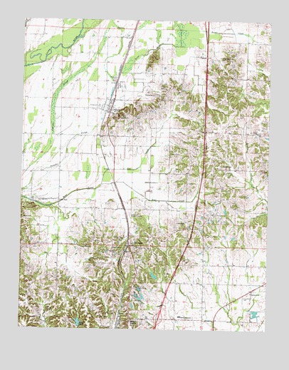
Pulaski, IL USGS Topographic Map
Click on map above to begin viewing in our Map Viewer.

This topographic map contains these locations and features:
Feature Name Type Latitude Longitude GNIS ID View Map
America Election PrecinctCivilN37.1426°W89.1286°1928430View Map
Bethel CemeteryCemeteryN37.1323°W89.2356°404262View Map
Bethel ChurchChurchN37.1292°W89.2392°404282View Map
Briar CreekStreamN37.2245°W89.2040°404833View Map
Bryan School (historical)SchoolN37.2198°W89.1465°1725628View Map
Cairo City CemeteryCemeteryN37.1584°W89.1983°405341View Map
Center ChurchChurchN37.2048°W89.1309°405787View Map
Eastwood CemeteryCemeteryN37.2350°W89.1459°407719View Map
Eastwood Church (historical)ChurchN37.2348°W89.1456°1725632View Map
Edith ChapelChurchN37.1767°W89.2306°407797View Map
Egyptian Country ClubLocaleN37.1417°W89.1912°424866View Map
Green Lawn Memorial GardensCemeteryN37.1712°W89.1953°409387View Map
Henderson CemeteryCemeteryN37.2262°W89.2037°410047View Map
Hogendobler CemeteryCemeteryN37.1678°W89.1667°410362View Map
Illinois No Name Number 86 DamDamN37.1467°W89.2217°1691022View Map
Interchange 8CrossingN37.1292°W89.1795°1820620View Map
Kays LakeReservoirN37.1276°W89.2201°411332View Map
Kays Lake DamDamN37.1262°W89.2201°1690947View Map
King-McNeil CemeteryCemeteryN37.1384°W89.1367°411497View Map
Lackey CemeteryCemeteryN37.2053°W89.1970°411674View Map
Liberty CemeteryCemeteryN37.1953°W89.1742°411984View Map
Lincoln CemeteryCemeteryN37.1313°W89.2017°412110View Map
Macedonia ChurchChurchN37.1398°W89.1329°412790View Map
Manwaring CemeteryCemeteryN37.2198°W89.1834°412917View Map
Meridian High SchoolSchoolN37.1303°W89.1690°413427View Map
Mize CemeteryCemeteryN37.2467°W89.2004°413690View Map
Mount Calvary CemeteryCemeteryN37.1559°W89.2001°413934View Map
Mount Pleasant School (historical)SchoolN37.2142°W89.1834°1725637View Map
New Shiloh CemeteryCemeteryN37.1594°W89.2173°1820623View Map
Old Shiloh CemeteryCemeteryN37.1526°W89.2132°415060View Map
Perkins School (historical)SchoolN37.1887°W89.2351°1725641View Map
Pleasant Hill School (historical)SchoolN37.1309°W89.2406°1725642View Map
Pleasant Valley School (historical)SchoolN37.1253°W89.2365°1725643View Map
PryortownPopulated PlaceN37.1903°W89.1487°416274View Map
PulaskiPopulated PlaceN37.2137°W89.2059°416278View Map
Pulaski CountyCivilN37.2229°W89.1266°1784966View Map
Pulaski County Ambulance ServiceBuildingN37.1301°W89.1763°2673765View Map
Pulaski Election PrecinctCivilN37.2154°W89.2000°1928631View Map
Pulaski Fire StationBuildingN37.2131°W89.2069°2640236View Map
Pulaski Post OfficePost OfficeN37.2128°W89.2068°2788683View Map
Rife School (historical)SchoolN37.2028°W89.2406°1725645View Map
Rose Hill CemeteryCemeteryN37.2112°W89.2003°1820626View Map
Rose Hill ChurchChurchN37.2109°W89.2012°416946View Map
Shiloh ChurchChurchN37.1584°W89.2167°418405View Map
Southside School (historical)SchoolN37.1903°W89.1420°1725647View Map
Sow CreekStreamN37.1837°W89.2098°418864View Map
Spencer HeightsPopulated PlaceN37.1273°W89.1948°418894View Map
True Light ChurchChurchN37.1767°W89.2370°419903View Map
Valley Recluse School (historical)SchoolN37.1364°W89.1715°1725649View Map
Villa RidgePopulated PlaceN37.1587°W89.1948°420315View Map
Villa Ridge Election PrecinctCivilN37.1665°W89.2079°1928668View Map
Villa Ridge Post OfficePost OfficeN37.1587°W89.1954°2788799View Map
Village of PulaskiCivilN37.2163°W89.2078°2399029View Map
Walford CemeteryCemeteryN37.1700°W89.2490°420393View Map
West Union School (historical)SchoolN37.1962°W89.1709°1725650View Map

Note: Coordinates in the location and feature list above are referenced to NAD83 datum.


Copyright (C) 2008-2024 Ryan Niemi / Sunset Dynamics ... All Rights Reserved