TopoQuest Logo
Do you find TopoQuest useful?
Help keep TopoQuest running and adding new maps/features by donating!
Bitcoin:  19c7KJd3qBynnjoSw5npx9KScwjBe4ifkT
Litecoin:  LXs6TkuXGGXo1vDsWCkWVdjQX94eUKd6ui
Home View Maps Find Maps Find Places Resources & Links


McClure, Illinois Topographic Map

USGS Map Title: McClure, IL
USGS Map MRC: 37089C4
DRG (GeoTIFF) Download: o37089c4.tif


Neighboring USGS Topographic Map Quads:


  Cape Girardeau NE, MO  
37089D5
 

  Ware, IL  
37089D4
 

  Jonesboro, IL  
37089D3
 

  Cape Girardeau, MO  
37089C5
 

  McClure, IL  
37089C4
 

  Mill Creek, IL  
37089C3
 

  Scott City, MO  
37089B5
 

  Thebes, IL  
37089B4
 

  Tamms, IL  
37089B3


Map MRC Location:

N38°
W90°
N38°
W89°
H8 H7 H6 H5 H4 H3 H2 H1
G8 G7 G6 G5 G4 G3 G2 G1
F8 F7 F6 F5 F4 F3 F2 F1
E8 E7 E6 E5 E4 E3 E2 E1
D8 D7 D6 D5 D4 D3 D2 D1
C8 C7 C6 C5 C4 C3 C2 C1
B8 B7 B6 B5 B4 B3 B2 B1
A8 A7 A6 A5 A4 A3 A2 A1
N37°
W90°
N37°
W89°

McClure, IL USGS 1:24K Topographic Map Preview:
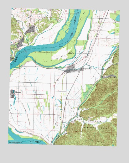
McClure, IL USGS Topographic Map
Click on map above to begin viewing in our Map Viewer.

This topographic map contains these locations and features:
Feature Name Type Latitude Longitude GNIS ID View Map
Big Inch Pipe LineLocaleN37.3414°W89.3806°424642View Map
Blue HollowValleyN37.2730°W89.3841°404591View Map
Brooks SchoolSchoolN37.3592°W89.4779°714750View Map
Cape RockSummitN37.3287°W89.4959°715382View Map
Clear CreekStreamN37.2770°W89.4218°406203View Map
Devils IslandIslandN37.3298°W89.4487°407158View Map
Dongola HollowValleyN37.3130°W89.3933°407305View Map
East Cape - McClure Fire DepartmentBuildingN37.3185°W89.4296°2640151View Map
East Cape Election Precinct (historical)CivilN37.2851°W89.4773°1928487View Map
East Cape GirardeauPopulated PlaceN37.2959°W89.4962°1669473View Map
East Cape Girardeau Airport (historical)AirportN37.2878°W89.4515°427481View Map
East Cape Girardeau SchoolSchoolN37.2953°W89.4990°407619View Map
Edmondson SloughLakeN37.2903°W89.4935°407798View Map
Flora CreekStreamN37.3403°W89.4768°718034View Map
Hacker BendBendN37.2503°W89.4501°422201View Map
Happy HollowValleyN37.3259°W89.3823°409762View Map
Hobbs ChapelChurchN37.3409°W89.4954°719644View Map
Hobbs Chapel CemeteryCemeteryN37.3414°W89.4957°2681388View Map
Horse CreekStreamN37.2828°W89.4198°410553View Map
Juden CreekStreamN37.3342°W89.4920°720446View Map
KGIR-AM (Cape Girardeau)TowerN37.3009°W89.4909°759210View Map
KZIM-AM (Cape Girardeau)TowerN37.3164°W89.4851°759189View Map
Lindsay CemeteryCemeteryN37.3148°W89.3906°412237View Map
Little Flora CreekStreamN37.3625°W89.4465°721235View Map
Main DitchCanalN37.2959°W89.4087°412857View Map
McCavens School (historical)SchoolN37.2692°W89.4029°1725718View Map
McClurePopulated PlaceN37.3178°W89.4315°413206View Map
McClure Election PrecinctCivilN37.2938°W89.4322°1928563View Map
McClure Post OfficePost OfficeN37.3183°W89.4302°1808567View Map
Old Clear CreekGutN37.3234°W89.4148°415007View Map
Picayune ChuteStreamN37.3292°W89.4829°415628View Map
Picayune IslandIslandN37.3328°W89.4229°415629View Map
ReynoldsvillePopulated PlaceN37.3673°W89.3951°423110View Map
Reynoldsville SchoolSchoolN37.3606°W89.3973°416572View Map
Scism CreekStreamN37.3406°W89.4770°726132View Map
Shawnee Elementary School-SouthSchoolN37.3173°W89.4373°1808571View Map
Soakie CreekStreamN37.3728°W89.4604°726680View Map
Swiftsure TowheadIslandN37.3692°W89.4176°419488View Map
Village of East Cape GirardeauCivilN37.2957°W89.4869°2398772View Map
Village of McClureCivilN37.3147°W89.4332°2399286View Map

Note: Coordinates in the location and feature list above are referenced to NAD83 datum.


Copyright (C) 2008-2025 Ryan Niemi / Sunset Dynamics ... All Rights Reserved